Day 166 – Loneliest Road in America, May 12, 2011
I started the morning at the local coffee shop. It seems like almost every town in  America has a coffee shop these days. I grabbed a drip and muffin to go and sped along Highway 50, also the Lincoln Highway, for 75 miles until I reached Ely. Here I picked the Convention Center and Visitor Bureau to stamp my survival guide. With my five stamps, I can now claim that I have survived “The Loneliest Road in America”. I plan to mail the postage paid card to the State of Nevada to receive my certificate signed by the Governor!
While in Ely, Petey and I noticed a sculpture garden across from the Chamber of Commerce. Spent 150MM, 75MM, and 88M rifle shells were used to create a  figure that resembles an indigenous desert plant. Another sculpture large sculpture represents ore tipples which were used to load ore for transportation from the mines. A sculpture of steel scrap resembling a pagoda paid homage to the many oriental who labored in mining work.
After visiting the sculpture garden, geocaching took Petey and I for a walk along some side roads past countless mural covered buildings, next to the Nevada Hotel, through a cemetery, and finally to the Nevada Northern Railway. We found three of the four. One was going to draw too much attention, so we moved on. I really like the cache hidden at the Nevada  Northern Railway, which once served local copper mines. I had planned to tour the former depot and rail yard regardless, but I wouldn’t have crossed all the tracks if it hadn’t been for the hidden ammo
  can. It was great because I would have never expected to find such a large cache nearby…perhaps a micro. It was hidden with the permission of the staff. I picked up a travel bug attached to a used shotgun shell and plan to drop it at another location soon. I addition to finding the cache, I got to walk in buildings that shelter the trains to get an up close look at the old steam engines that transport tourists around on the weekends. It’s not often visitors can just meander around a working rail yard…what fun!
 After a morning spent in Ely, we continued on to see the Ward Charcoal Ovens, 15 miles outside of town. The ovens were constructed by Italian masons to produce charcoal. The ovens, 30 feet in height and 20 feet in diameter, held 35 cords of wood. It took tree crop from 5 to 6 acres of land to fill one oven. The hills around mining camps in the 1800’s were stripped bare. Each cord of wood produced 30 bushels of charcoal which was hauled to smelters to reduce the ore. One ton of ore required the use of 30 to 50 bushels of charcoal. As railroads penetrated the west, charcoal was replaced by coke made from coal, and the charcoal industry faded. I was simply amazed to see the well preserved condition of these enormous ovens.
Leaving the ovens along a dirt road, we got the pleasure of witnessing two  pronghorn grazing in the sage brush covered valley. I’ve never been able to get so close to a pronghorn. I stopped right in the middle of the road for a good long look. We resumed our travels to the Great Basin National Park and Lehman Caves. We arrived just in time to pick a campsite, do a little housekeeping, and to sign up for the three o’clock tour of the cave explored by Absalom Lehman in 1885. I may not have gone on the cave tour except the parent I met yesterday at Grimes Point raved about it. I must say, the cave was special in selected ways.
 Extending only a quarter-mile into the limestone and marble at the base of Snake Range, it isn’t as grandiose as Mammoth Caves or Carlsbad Caverns, but it has fantastic formations, including the typical stalactites, stalagmites, columns, draperies, flowstone, bacon, and soda straws as well as rarities such as shields, helictites, and cave popcorn. The speleothems take centuries to form drip by drip. In this particular cave, based on the average precipitation, it takes 100 years for the formations to grow one inch!
Shields are two circular plates fastened together like a clam shell. Often times,  stalactites and draperies hang from them. Lehman Caves is known for its abundant shields. Cave popcorn looks just like the edible type and helictites appear to defy gravity as they attach themselves to a stalactite but grow out and upward as opposed to down.
Having recently gone caving on my own in lava tubes at  Lassen Volcanic National Park, I think I gained a greater appreciation of caves as well. The thought of Absalom Lehman and his several guests who explored the cave by candlelight without a passageway is simply incredible. I was so thankful for a guided path and lights to enjoy the beauty
  of the cave. The colors changed from greys to greens to pinks to browns. While most of the cave was adorned with countless formations, some of the walls and ceilings were smooth from a heavy flow of water. In addition, this time of year, water still pooled on the floor in an area known as the King’s and Queen’s Bathtubs and the Swamp.
Knowing how long it takes for the speleothems to grow, it was slightly  disheartening to see the damage created from early visitors, but at the same time, it was neat to appreciate the history. These folks inscribed their names and dates into the cave ceiling with their candles. Unfortunately, they also took a souvenir with them, but I’d take one too if I were allowed. The cave was also special because visitors were able to travel so close to the formations. Cameras actually worked and didn’t capture complete darkness.
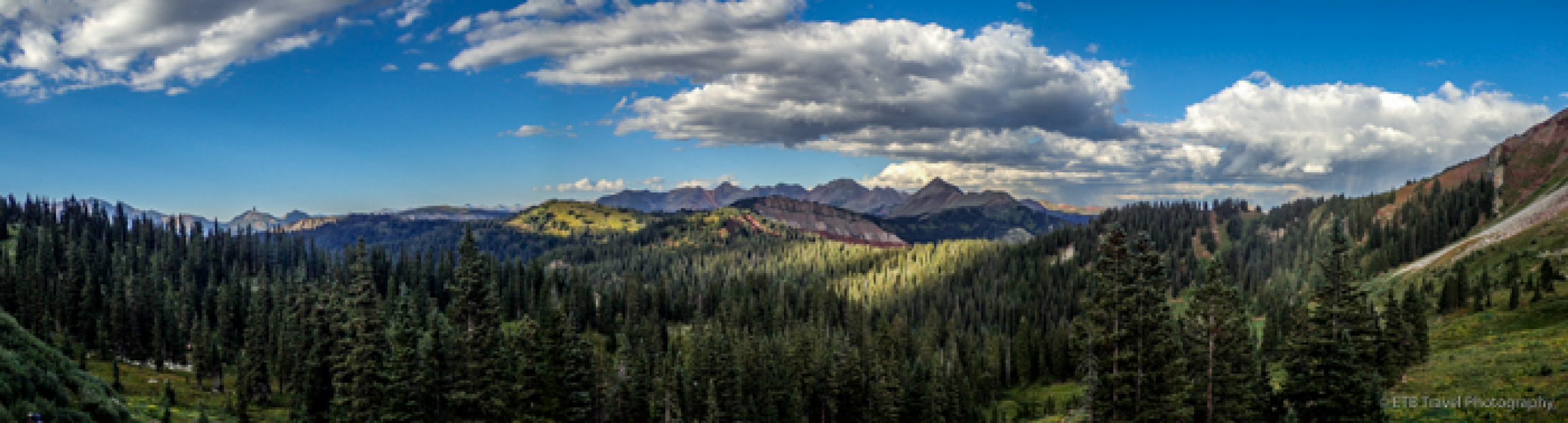
 After the lovely tour, I joined Petey in VANilla and snaked up Wheeler Peak Scenic Drive to Mather Overlook. The overlook sits below Wheeler Peak and provides a view of the Great Basin from which the water doesn’t leave. The rivers in this area don’t drain to the Pacific Ocean; the water stays in the basin. We wound back down the mountain and stopped at the Osceola Trail where I took a quick walk along a tiny creek as a rabbit scampered across my path to Osceola Ditch.
In 1872 over $2 million of gold laid buried in Dry Gulch, but too little water  made large-scale operations impossible. In 1889 construction began on an 18-mile aqueduct to carry water from Lehman Creek to the mining area. Almost a year later, the aqueduct was complete at the cost of $108,223. The ditch was abandoned in 1901 as inadequate gold production coupled with water shortages from dry winters did not yield enough profits.
We continued the rest of the way down the mountain to our campsite and called it the day. ETB.
Amazing photos once again!
I enjoyed seeing your photo of the Pronghorn. I’ve never seen one before.
Xo’s M