Day 177 of Year Long Roadtrip Following Scenic Byways in the USA
Bryce Canyon National Park
I spent the whole day in Bryce Canyon National Park, and it was fantastic. As I drove to the park, bright and early, the cloud covered sky sprinkled drops of rain. Just before the park entrance, I stopped at some forest land to let Petey water a few trees, and during our 5 minute stroll it started sleeting on us. I could see a few sections of blue sky beyond the black cloud, so I hoped for the best once I arrived at Bryce Point. As I continued a mile further, I saw a rain drop defy gravity and flutter upward in the wind…no, it was actually a snow flake. I saw only a smattering of snowflakes before I passed through some intermittent sprinkles and finally parked at Bryce Point where I prepared for a 5.5 mile hike.
Bryce Point (Under-the-Rim Trail and Peekaboo Loop)
The wind seemed to be moving the large, black cloud with quite some pace, and after fifteen minutes of fiddling around, I marched down the Under-the-Rim Trail beneath sunny skies! The weather was simply remarkable. I’ve never seen anything like it. In the sun it was warm, in the shade and when the wind blew it was cold, and when a black cloud hovered it briefly snowed or rained.
I connected the Under-the-Rim Trail with Peekaboo Loop which is listed under “strenuous” in the park newspaper and is described as “steep but spectacular hike through the heart of the Bryce Amphitheater”. It is suggested to allow 3-4 hours to complete the 5.5 mile loop beginning at 8,315 feet and descending over 1,500 feet to 7,429 feet before returning back to Bryce Point.
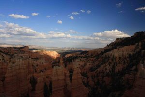
The sandy path, wet in places, wound through the amphitheater, a collection of hoodoos, sculpted by water over time. Over millions of years, water seeped into cracks of both hard and soft layers of rocks creating thin ridges called fins. The fins eroded into spires and pinnacles called hoodoos – so named for their resemblance to ghostly hooded figures. The rocks are stained in vivid hues of orange, pink, red, tan, and grey, due to various minerals that have oxidized. The kaleidoscope of tinted towers interlaced with dark green pines and highlighted by a cobalt blue sky filled with brilliant white clouds added to the dramatic view.
Scenic Overlooks in Bryce
I finished the breath-taking trek in about two hours, joined Petey in VANilla, and followed the scenic drive to countless overlooks: Rainbow Point, Yovimpa Point, Black Birch Canyon, Ponderosa Canyon, Agua Canyon, Natural Bridge, Farview Point, Piracy Point, Swamp Canyon, Paria View, Inspiration Point, Sunset Point, and Sunrise Point. Petey enjoyed lots of short walks from the parking lot to the viewpoint. A pleasant surprise as VANilla climbed to 9,100 feet was to find snow interspersed within the spires.
I found Inspiration Point to be the most grand while Piracy Point and Black Birch Canyon were special due to the snow. Natural Bridge was an interesting stop simply because the formation is misnamed. The bridge is technically an arch. Natural bridges are carved by rushing steams not subtler forms of weather that have sculpted Natural Bridge.
World’s Best 3-Mile Hike
After visiting all the viewpoints, I took advantage of the showers and laundromat at the Bryce Canyon Store, and waited for the early evening to take the “World’s Best 3-mile hike!” in the setting sun. The Park’s newspaper suggests beginning at Sunrise or Sunset Points and connecting three trails; Queens Garden Trail, Navajo Loop, and the Rim Trail for a moderate, 2-3 hour walk.
I started at Sunrise Point, descended 600 feet along the Queens Garden Trail so named for a hoodoo that has a striking resemblance to Queen Victoria, and ascended up Navajo Trail among countless steep switchbacks past Wallstreet.
In addition to the fantastic hiking, I got to log four virtual geocaches – Natural Bridge, Wallstreet, Inspiration Point, and Fairyland Canyon. Fairyland Canyon was my last stop for the evening which is located just outside the entrance to the park. On the way toward the exit, we passed by mule deer and pronghorn grazing in the meadow. Fairyland Canyon was special simply because it was quaint and peaceful with only one other person enjoying the solitude nearby. ETB
Other Articles About Utah You May Like
Day 171 – Monument Valley Meander
Day 172 – Monument Valley Meander (Part 2) and Utah Byways
Day 173 – Utah Byways (Part 2)
Day 174 – Utah Byways (Part 3)
Day 175 – Utah Byways (Part 4)
Day 176 – Bryce Canyon Country
Day 178 – Bryce Canyon Country (Part 3) and Zion Canyon Loop
Day 179 – Zion Canyon Loop (Part 2)
Day 180 – Zion Canyon Loop (Part 3)
Day 181 – Zion Canyon Loop and Utah Byways (Part 4)
Day 182 – Utah Byway (Part 5)
Day 183 – Utah Byways (Part 6)
Day 184 – Monument Valley Meander (Part 3) and San Juan Skyways
Day 203 – Flaming Gorge Getaway
Utah’s Olympic Park
Hiking Deer Valley Resort
Park Silly Sunday!
Shop
Check out the photographic note cards and key chains at my shop. Each card has a travel story associated with it. 20% of proceeds are donated to charity.


Fabulous photos once again. Sounds like you had a great day and that Bryce lived up to it’s reputation. Awesome!
Beth, your photos are breathtaking……I know I say it all the time, but you need to get them published
Ditto to Diane’s comment. And another book just for Bark of the Day. I always look at those first. Petey rocks!
That’s funny because I always look at Bark of the Day also!
Beautiful! Love the pics!
Wow… these are some of your beth photos. Bryce Canyon National Park has now been added to my “bucket list”.
yes, definitely should get there
woops… some of your best photos Beth. 🙂