David and I set out to hike segments 8-10 of the Colorado Trail (the “CT”) from Copper to Leadville over five days which averaged just under eleven miles a day after including our side hike to the fish hatchery. On the sixth day, we tackled Mount Massive, the second highest peak in Colorado. It was an eventful trip!
Getting There
We didn’t get started until Friday afternoon. It was good to own both the descriptive Colorado Trail Book as well as the small databook, as we found some discrepencies between to the two right from the start. After shuttling one car to the end of segment 10, we followed the directions in the Colorado Trail book to the Wheeler Flats Trailhead near Copper just south of 70 from exit 195. Upon arrival we found a sign warning “No Overnight Parking”. Fortunately, our databook mentioned that we needed to park in the Copper East Lot, though we didn’t know where this lot was located.
A workman pointed us just slightly farther south. We found the lot which was full of construction equipment and was “closed” to the general public. Along with a few others, we drove around the barricade and found a small parking area for the Colorado Trail which was also the Continental Divide Trail for much of our trip.

Day 1
The book generally mentions each time there is a street crossing, however, once we got headed in the right direction (toward Durango), we had to cross Hwy 91. We hiked beneath the lifts at the Copper ski resort, past lovely wildflowers, across a seasonal stream, and across a much larger creek at the base of the ski mountain which was active with summer tourists.
We continued ascending from 9,820 feet up to 10,854 feet over the 6.5 miles. The ascent led us along a road, a single track trail in the woods, and an elongated meadow. From all the spring snow and rain, the meadow was lush with green grasses and bushes.
If we didn’t stop at the end of the meadow to camp, according to our information, we would have had to hike two more miles to find another campground, so we settled on a somewhat flat spot in the open near the remains of a historic building.


Campsite
The campsites were few and far between despite the book saying good camping, so our little spot soon became a commune for six through hikers, most of them from the East Coast. They set up their tiny tents right next to us.
It didn’t take long for the afternoon Colorado rain to visit, so we took cover in our single pole tent. Fortunately, the storm was short lived so we enjoyed our campfire and roasted marshmallows as the sun set.


Day 2
We rose early to a dewy meadow and the sun shining. Eventually we packed up and began a ten mile day. The trail led us above treeline where we found two ravens resting on either side of the path.
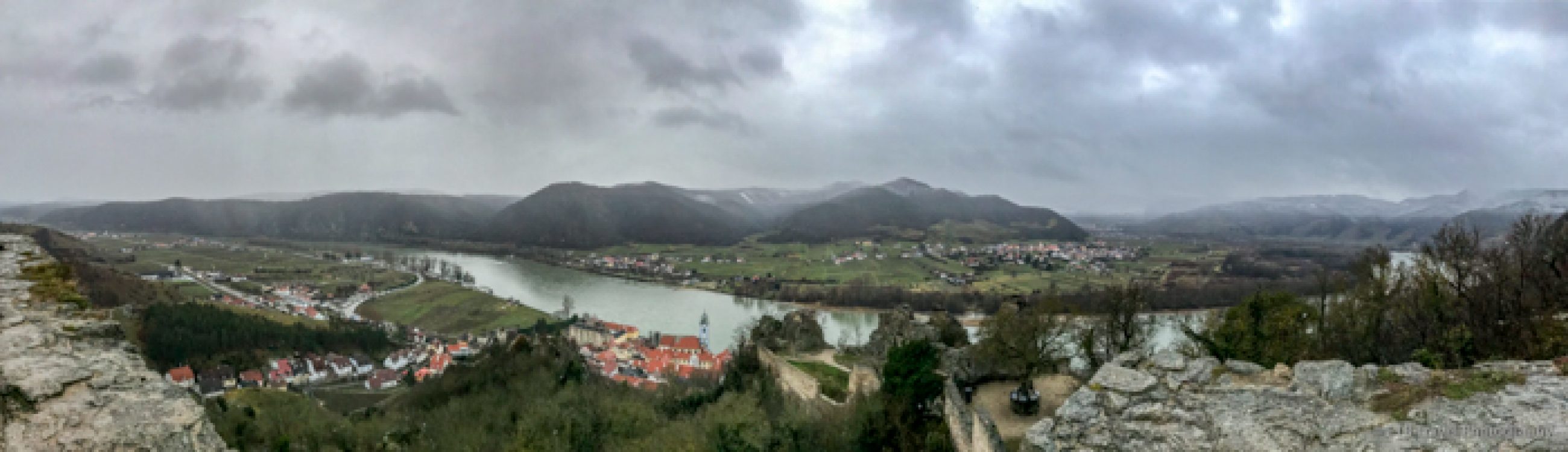
Soon we passed Janet’s Cabin, a popular ski hut, chatted with some of the volunteer trail workers, crossed another creek, and stopped briefly to take in the view at Searle Pass which was magnificent.
The well marked trail led us through the alpine tundra full of forget-me-nots and moss campion which are two of my favorite wildflowers.


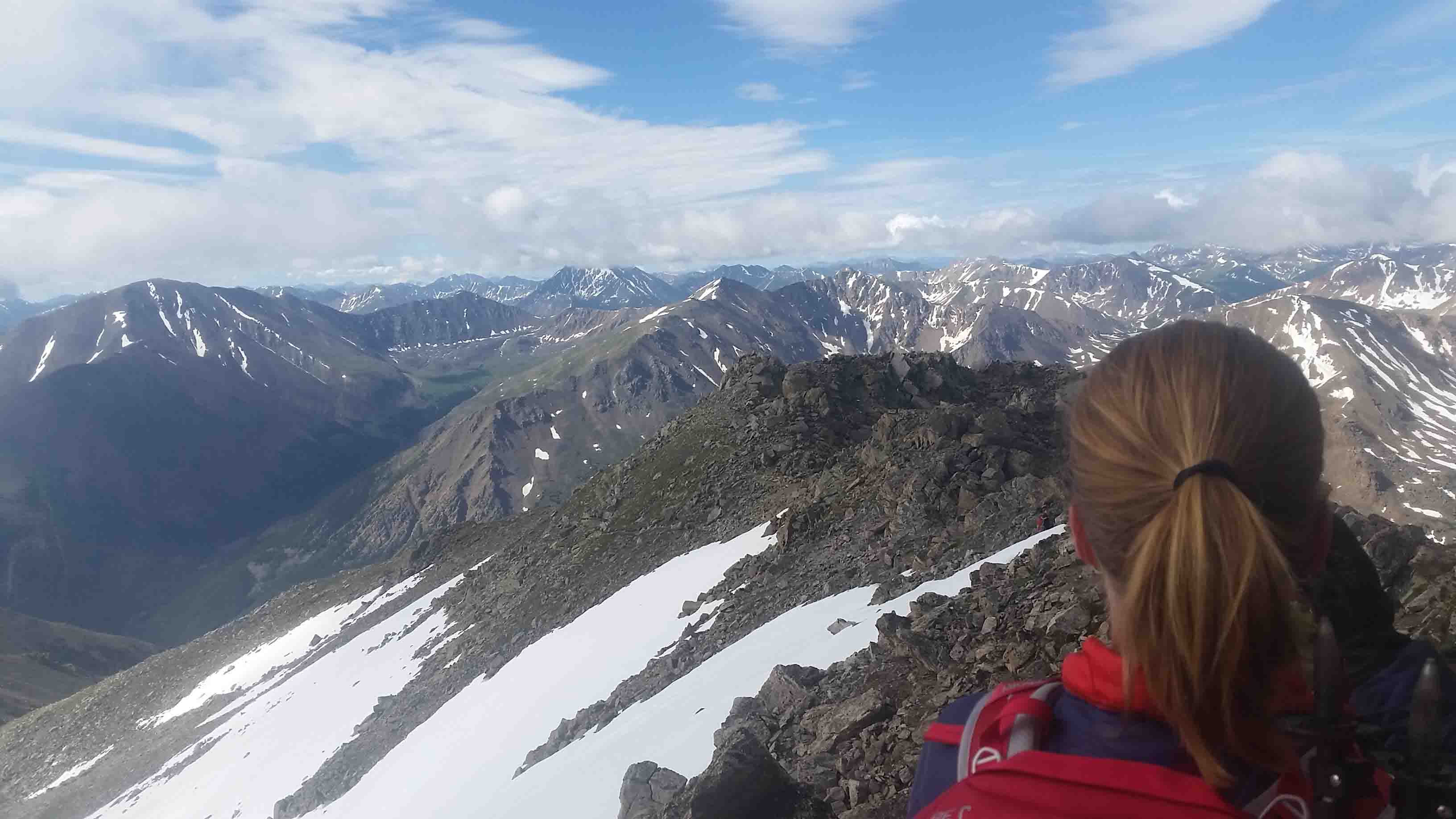
Around noon after passing several creeks and post holing through a little snowpack, we reached Elk Ridge, the highest point on Segment 8 as well as the highest point of the three segments we were backpacking. No sooner did we reach the top, than a dark cloud rolled over dropping snow pellets on us.
We were planning on having lunch here, so David asked if I wanted sit in the small ditch to get out of the whipping wind. That would have left us without a view, so I declined. Lucky for us, the wind was so strong, the cloud kept on moving and the sun came out! We settled down just below the ridge to get out of the wind for our cheese and sausage lunch while admiring the valley below.


Engaged
After lunch, David took my hands and led me to the point on the ridge, got down on one knee and proposed as the marmots looked on! It was a lovely proposal in an amazing and meaningful place, as I want to complete the whole trail over the next few years.
Girls always want to know about the ring…I can easily say, it is beautiful! While I could go on and on about the whole experience, to me it is a moment between us, so enough said.


After getting engaged, we descended along Kokomo Pass through the alpine meadow as we took in more fantastic views. This area of the trail is truly spectacular. We continued below treeline for 3.5 more miles blessed by lovely aspen groves when we found an awesome campsite next to Cataract Creek.
While it was early in the day, around 2 pm, we thought we should snag the space as camping for the next three miles was off limits. For our engagement dinner, we chowed down on coconut beans and rice and capped it off with more roasted marshmallows which are a treat at the end of the day!


Day 3
On our third day, we continued on Segment 8 from mile marker 16.5, this time descending through lodge pole pines to a marvelous waterfall. For the next few miles, we followed the trail through a field of sage alongside a dirt road through a sun drenched valley.
Camp Hale
We came upon a herd of sheep before reaching Camp Hale, home to historic concrete bunkers. The camp was established in 1942 to train troops for winter warfare during World War II. Camp Hale was dismantled in 1963, but not before many of the 5th Army 10th Division returned to the area to establish the ski industry after having one of the highest casualty rates (25%) in the war while fighting in Italy’s Apennine Mountains.


From here we ascended through the evergreen forest with the view of the road below. This part of the trail was somewhat drab with the exception of finding some edible, bolete mushrooms.
Soon we crossed highway 24 and the railroad tracks and meandered into a lovely valley of wildflowers, birds and butterflies. For any through hikers, I recommend filling up with water at the creek that runs through this meadow as there isn’t any water for the next 8 miles (more on this later)!
From the meadow, we ascended an abandoned railroad grade through the forest to enjoy lunch near the top of Tennessee Pass by the remains of old coking ovens used to transform coal in to high-grade “coke” for the production of steel.


Tennessee Pass
After passing through the parking lot at Tennessee Pass, we entered the trees again at the beginning of Segment 9 and hiked for another 2.5 miles to cap a 11.5 mile day at Wurts Ditch where the databook showed a picture of water and a tent. The databook also included a red exclamation mark claiming the water was scarce and unreliable at this location. I should have paid closer attention to this symbol!
There has been so much rain and snow, David and I both thought we would find water here by a nice campsite. Having just drained our camelbacks, boy were we surprised. Wurts ditch should be renamed dry ditch, and I don’t even think it should be mentioned as a water source as I can’t figure out when any water would be there if it wasn’t after this year’s crazy wet spring!


The databook mentioned we could find water in a mile, but it did not mention any campsites for the next four miles. We were about to pitch our tent at this dry campsite and walk to the creek when we decided to consult the more detailed book.
This book claimed more campsites were by the creek a mile away. We willingly hoisted our packs on our backs as we were getting eaten alive by vicious mosquitoes! Not an ounce of water to be found, but mosquitoes buzzed all around us.
Trail Angel
We carried on across the dirt road and not too far beyond this intersection we came upon a blue cooler marked with the CT and CDT emblems. Wow, angels were watching over us and all the other hikers that have probably been hosed at Wurts Ditch. The cooler was full of ice cold soft drinks and beer! What a welcome delight!!
We both polished off a soft drink before continuing to the creek and finding what we thought was an excellent campsite until the mosquitoes swarmed again. Deep Woods Off couldn’t protect us from those blood suckers. We finally caved and took to our tent shelter until the sun set. I suppose we needed to as we passed out and woke up later, just to roast marshmallows, hang our food, and go back to sleep after our 12.5 mile day.


Day 4
Our fourth day on the trail began with ascending into the Holy Cross Wilderness Area and eventually reaching the saddle at Porcupine Lakes at mile marker 7.7 on Segment 9 (about 4 miles from our previous campsite). This ascent offered some lovely views. The next few miles of the trail passed by several lakes. There was no shortage of water (or mosquitoes) here. We had a long 14 mile day in front of us, so we didn’t stop for much more than some pictures.


After gaining 1,000 feet and then descending 1,000 feet out of Holy Cross Wildnerness and into segment 10 of the CT, we ascended another 1,000 feet. Alot of ups and downs today! After passing over a few seasonal streams, we reached a campsite with another seasonal stream around 11,000 feet.
While below treeline, it was in an open area with a magnificent view of the valley below. We were happy to snag this spot as the rain drops began to fall. We got our tent set up in record time and jumped in just before the hail started falling.


Storms
This afternoon storm blew over as well, so we enjoyed a nice campfire as we watched the clouds roll across the valley. Unfortunately, this was not the only storm, and we were awaken by bright flashes of light and thunder. The lightning was so bright, with our eyes closed in the tent, it still felt like our eyes were burning.
We counted the seconds between the lightning and thunder…5,4,3,2…and then all the way back to 8. The rain hit the tent so hard, mist sprayed down on us intermittently. Honestly, we felt a bit spooked. It was a welcome relief when the rain subsided. Not only for safety but also for a bathroom break. Upon crawling out of the tent, we found a little snow that had accumulated on one side of our shelter.
Day 5
Our plan for the fifth day, was to complete the final ten miles of segment 10 in the Mount Massive Wilderness area with the option to visit the fish hatchery that our book mentioned was two miles away. We just didn’t know if that was two miles one way or round trip.
Fish Hatchery
When we reached the fish hatchery sign, sooner than expected, we took a left and followed the road down 1,500 feet over two miles. The hatchery was home to cutthroat trout and once was an old resort. It was pretty cool and we enjoyed nice bathrooms and mirror too!
Having said all this, we had to climb back up 1,500 feet over two miles. This was not exciting given the hatchery is reachable by road, and we could have driven there sometime! What was even more unexciting is after we climbed back up, we descended the other side of the ridge only to find another fish hatchery sign.
My recommendation for anyone going from Denver to Durango is to skip the first fish hatchery sign and go to the second one. I don’t know if the trails were equidistant, but the second trail by the creek appeared to be flat!


Mount Massive Parking Lot
We continued for the next six miles, first climbing up to another viewpoint for lunch and then crossing a variety of creeks, small and large to end at the Mount Massive parking area to retrieve David’s truck. His four wheel drive, high clearance vehicle was able to maneuver the rough dirt road for 2.5 miles to a camping area near the North Halfmoon Creek Trailhead.
Along the way, we found what we thought was some awesome firewood, but it turned out to be extremely green. With the drizzle falling, the fire took a LONG time to get going. As such, our roasted marshmallows were most appreciated before we rose for a final day, a hike up Mount Massive.


Mount Massive
We ditched our backpacks, and went to our day packs for our eight mile roundtrip climb up Mount Massive. This route, which gains 3,950 feet over four miles is less popular than the other route where we ended yesterday, but I think that is due to the rough road, impassable for many vehicles. The other route, while less of a grade, is 14.5 miles long!
We wandered through the tree cover for the first mile and half or so before we started climbing. The views on this fourteener were spectacular. At one point, I think I counted seven lakes in the valleys below. The snow capped mountain ranges in the distance went on forever. The wildflowers were magnificent. Some of the blue columbines looked almost white which seemed unusual.


While the wind was whipping once we rounded the bend which required us to hike in a hat, gloves and our puffy, it was a pleasant surprise to not encounter any loose scree. In addition, the bouldering was limited. We reached the ridge and could mostly walk right across the top.
The Summit
Of course, sometimes I got sick to my stomach and dizzy because I’m not fond of ledges, though I suspect most people wouldn’t consider any of the path a ledge. We enjoyed the sun on the summit for lunch, but clouds just kept rolling in like they had the last few days. Fortunately none were black and there was no sign of lightning or thunder.
None the less, after a half hour on the summit, we headed down in order to avoid any chance of rain and finished in six hours or so at a leisurely pace. David rocked his first fourteener!!


It was a great climb and hike! We felt a great sense of accomplishment, but more importantly, for obvious reasons, it was a very special trip! ETB
Shop
Check out the photographic note cards and key chains at my shop. Each card has a travel story associated with it. 20% of proceeds are donated to charity.


Congratulations. You don’t know me but I have been reading your blogs for several years, since your days in the Volkswagen. I have envied your freedom to travel and your positive attitude towards the challenges of exploration. My thoughts have been “what a neat young woman ” and I was happy to learn of your fairly recent experience with romance. I am so pleased that things seem to be working out for you in this new “adventure!” For your information I will have my eighty-first birthday this week and have been married for more than fifty-five years. I have been, and continue to be, an adrenaline junkie and drive a VW van. My best wishes to you and your fiance. Sam Pacifico From: Adventures of a Couchsurfer To: samhp@yahoo.com Sent: Friday, July 17, 2015 3:17 PM Subject: [New post] Engaged on Segment 8 of the Colorado Trail! #yiv3178536523 a:hover {color:red;}#yiv3178536523 a {text-decoration:none;color:#0088cc;}#yiv3178536523 a.yiv3178536523primaryactionlink:link, #yiv3178536523 a.yiv3178536523primaryactionlink:visited {background-color:#2585B2;color:#fff;}#yiv3178536523 a.yiv3178536523primaryactionlink:hover, #yiv3178536523 a.yiv3178536523primaryactionlink:active {background-color:#11729E;color:#fff;}#yiv3178536523 WordPress.com | http://www.notablenotecards.com posted: “July 10-15, 2015David and I set out to hike segments 8-10 of the Colorado Trail (the “CT”) from Copper to Leadville over five days which averaged just under eleven miles a day after including our side hike to the fish hatchery. On the sixth day, we t” | |
Sam, thank you so much for your kind words! I hope to be an adrenaline junkie at 81 too! Glad you enjoy my blog.
A beautiful account of a very special day……
Beth, Congratulations to both of you. I am so happy for you!
Hi,
I am wondering if we can rank your website adventuresofacouchsurfer.com on Google, Yahoo & Bing, without having you to pay upfront fee. Not until you are ranked… Would you be interested?
We specialize in Performance-based SEO, means you don’t pay if you don’t rank.
Kindly reply to me if interested.
Thank you,
Mr Sim
SEO Sales Specialist
What is the fee should I rank? Thanks
Please provide pricing if I do rank. Thanks!