
Inspiration
Recently many of my friends have been talking about hiking the Colorado Trail. One friend from Texas planned to hike the entire 485.8 miles in 3 weeks this summer. He just finished on Monday and picked up his car and excess belongings that he left at my house. Another friend is hiking a portion with her son starting tomorrow. And finally, another friend is hiking all the segments over five years. He has completed multiple trips, some day hikes and some backpacking trips, along the trail this summer.
These conversations coupled with recently finishing the book Wild by Cheryl Strayed which many people had suggested to me to read in the past two years (probably because I took a year away to travel and hike) inspired me to hike my first segment of the Colorado Trail or the CT today.
Getting There
I chose segment 3 because the 12.2 mile section ends just 4 miles down the road from our summer cabin where my parents were staying, thus I had an organized pick up at 3pm. I left my home in Denver sometime between 6:30 and 7 beneath cloudy skies, stopped for a few minutes in Pine Junction, enjoyed the lovely view of the grassy meadow cut by the flowing river along 126 before I finally turned onto 550. The trailhead location is in a fee area ($6 daily use) less than 0.1 miles down this dirt road on the right hand side.
Upon arrival at the parking lot, I prepared for my journey. I used the pit toilet, strapped on my ankle brace, placed the sunshades and parking sticker in my windshield, stuffed my rainjacket in my pack along with my previously packed lunch, ten essentials, a hat, gloves, and of course my selection of cameras and phone.
With my hiking poles in hand, I locked the car, stuffed the keys in my pack belt, and strolled to the trailhead sign just a few minutes after I watched two other hikers walk down the path. Despite not feeling that great, most likely due to flash floods on the Western Slope and storms projected for the front range in the afternoon, I had a nervous energy about me. I was so excited about starting this new adventure…someday completing the Colorado Trail.
The Start
So after stopping at the sign with the trail map, though I became engrossed with the blurb on the threatened butterfly, the pawnee montane skipper which makes its home only in this area, I headed down the trail. The trail widened almost to the width of a road beneath the warm sun. I thought to myself, “I’m glad I started at 8:30. It’s already hot, and I thought the Official Guide Book said this section was shaded. I guess I’ll be getting to the shade of the evergreens soon.”
I continued on and passed a road without any identification that went off to the left over a hump toward a meadow. I felt like I should be going that direction, but a better maintained trail with the official marker of two mountains turned toward the right. Eventually it crossed a paved road. I knew I was to cross a road, 550, at 0.6 mile, but it wasn’t paved. Too many things weren’t adding up in my foggy mind when I realized I was merrily following the trail in the wrong direction!


Oops!
This is a very embarrassing fact for me to admit, though I’m learning it’s OK to laugh at my mistakes (and it’s much more fun)! I’d like to blame it on my excitement, the fact I didn’t want to be walking right behind the other pair of hikers, my headache, or the headache preventative Topamax (kindly referred to as Dopamax by many who take it as it causes forgetfulness, lack of concentration, and otherwise “dumb blonde” moves), but the bottom line was I’m human.
Lucky for me I recognized my mistake when I got to Highway 126 so I could turn around, but too bad I ignored all my other instincts. By the time I arrived back at Little Scraggy Trailhead, it was 9:30. I had walked over a mile the wrong direction (and thus another mile back).
Restart
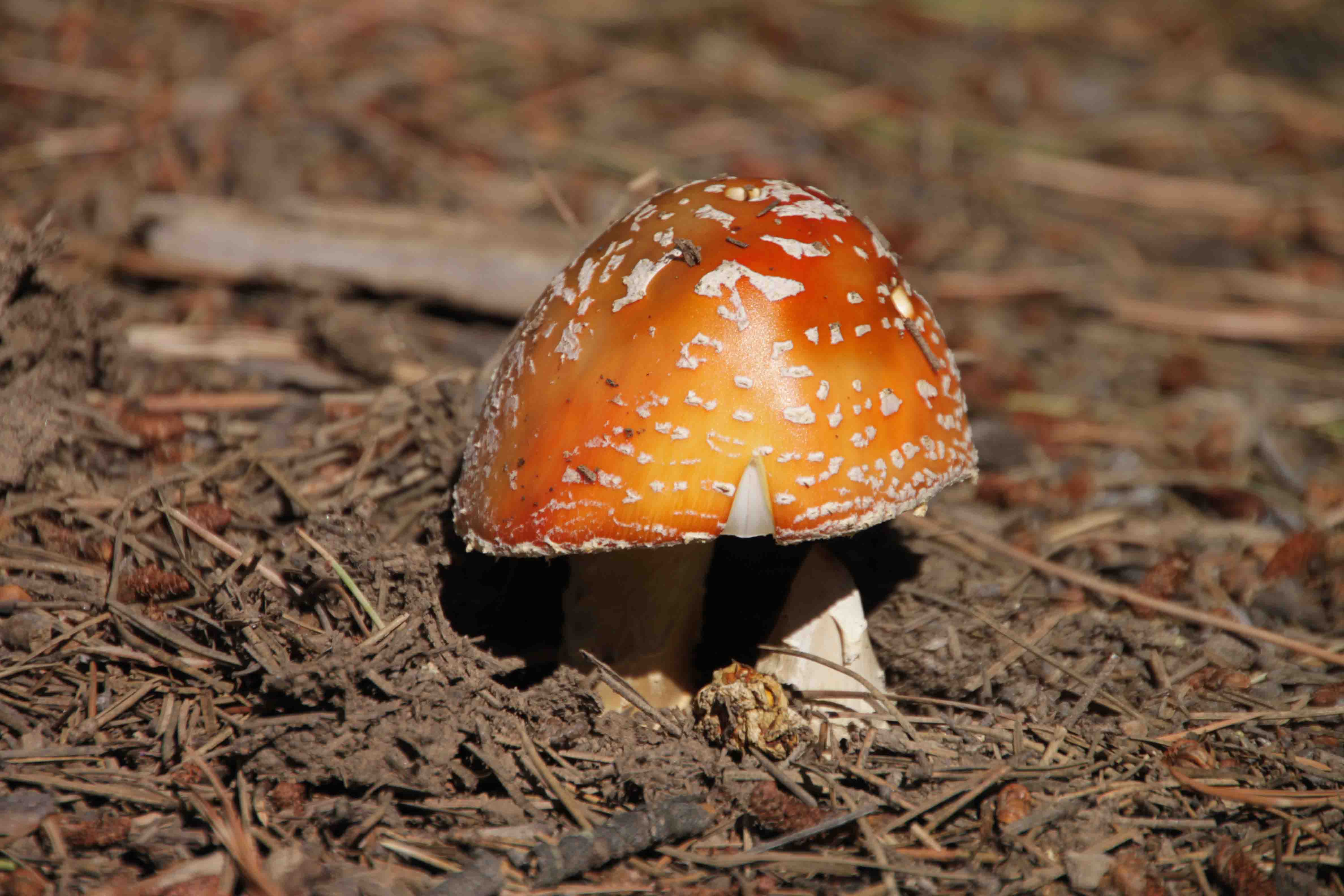
So, at 9:30, with my Map My Hike app reset, I began my hike again from behind the sign and headed directly into the shaded forest of ponderosa pine and douglas fir. From the ongoing, heavy rains of the summer seasons, the variety of mushrooms did not disappoint, white, brown, and red with white dots, just to name a few.
The trail weaved through some towering granite boulders that always make me wonder how they landed exactly that way. They seemed like a climbers paradise. At 0.6 mile, I crossed a dirt road, 550, and continued along the crushed granite path to the trail’s first water source around mile 1.3. At the crossing, the water was rather stagnant, though I could hear it running, so I suppose it was decent enough if treated. I’m not so sure this would be a reliable spot, however, during a dry year. The guide book describes the creek as “intermittent”.


I thought some of the prettiest part of the trail was in the beginning where boulders were strewn to the left of the trail. I yearned to stop for lunch in this area, but it was way too early in the hike and who knew what else I would see, as the first four miles maintained a relatively level altitude hovering around 7,800-7900 feet. I passed by Shingle Mill Trail and crossed another intermittent stream around mile 2. This water source sounded slightly stronger than the last, though stream is a strong statement.


Purple, white, yellow, and red wildflowers lined the trail. One day I will learn their names, and the names will stick. Now that I knew there was a rare butterfly in the area, I took particular care to photograph several, though I don’t think I succeeded in capturing the pawnee montane skipper that needs an open ponderosa pine forest to survive and feeds on the purple flowers.


Around mile 3, I found a better water source, though as a dayhiker, I was carrying enough water with me. After crossing the creek, the trail ascends up toward the left as an old road descends to the right. While there was good signage in the opposite direction, it was lacking in the direction I was headed. I just followed the well-traveled crushed, granite.
The views of the towering granite cliff and unique shaped rocks were a joy, though much of the forest appeared to be recently cut which was ashame. I’m assuming it was due to beetle kill, but I don’t know. Perhaps that is why the trail markers eluded me for a good while.


Soon aspen groves intermingled into the forest, and the path after peaking around 8,000 feet at mile 5 began gradually descending 500 feet over the next three miles. None of the hike required hiking poles, though I had them with me. Tramway Creek and a variety of campsites turned up around mile 5 as well.
I finally found a CT sign at the intersection of the Colorado and Tramway Trails. The official arrow pointed me straight though a few other arrows pointed me left and diagonal…all pointed in the opposite direction from the other choice, so I felt confident I was heading the correct way. Less than twenty minutes later, I intersected with Green Mountain Trail and followed the signs accordingly just in time to cross another creek.


Half-way There
About a half mile later at the next intersection, a post in the ground with some black marker scribble indicated I should go to the right. I had seven miles down and 5.2 to go. I continued descending another half mile to a creek which I crossed and followed the trail up through the meadow and to the Meadows Group Campground Road (continuing straight along the creek/gulley would have been the wrong way) but there wasn’t a marker.
Again, I picked what looked like the most traveled by mountain bikes. In the first five miles of the trail, I met three pairs of mountain bikers and one single rider. I also crossed paths with a runner and his dog and a set of four campers. Given the campers were in flip flops and one had his sleeping bag draped over his neck, I assumed they weren’t through hikers.


The Official Guide Book confirmed I was to cross the road, go through the gate and then veer left. Until this time, I had enjoyed the sunny, yet somewhat humid day for Colorado. Though I’m not sure humid and Colorado may be used in the same sentence.
There had been many clouds forming in the distance and one dark cloud above me spitting a few sprinkles for the last half hour, but nothing that required a raincoat. The intermittent cool drops felt refreshing. Just as I passed through the gate, however, a heavy drizzle fell from the clear sky. It’s amazing how that works!
I set down my pack, put up my camera, pulled out my raincoat, got a snack, walked along Buffalo Creek, crossed FS 543, turned left up the hill, and pulled off my raincoat after half a mile. I continued on until I met Redskin Creek Trail junction where there wasn’t a trail marker for the CT, but I assumed I should go on the unmarked path to the left versus the Redskin Creek Trail to the right.
Amazingly, each time I turned around at an unmarked intersection, the other direction was always marked with a CT emblem. I’m beginning to think it might be easier to walk the opposite way of the Official Guide Book. Perhaps people take the metal plate as a souvenir. It never failed that when I wanted to see a marker along the path, I could never find one, yet when I wasn’t looking I’d find three in a row.


The Last Four Miles
For the last four miles, the trail climbed from 7,500 feet to 8,300 feet through a healthy lodge pole pine forest with the occasional views of rock outcroppings on the distant ranges.
At mile 9.6, the trail crossed Buffalo Creek Gun Club Road. Here a sign tells hikers Wellington Lake Road is 2.5 miles away. This was my final destination. I had been pacing myself with the “Map My Hike” app. Unfortunately, it doesn’t calculate the mileage properly. At this stage, it had told me I was averaging a 23 minute mile pace and I was at mile 12.
As such, in my mind I had 0.2 miles to go, and I’d be in the parking lot with 35 minutes to spare. Instead, I had 2.5 miles to go in 42 minutes! I had wondered about this app as it seemed it had always been a bit generous with distance on hikes, but I was usually hiking less official trails.
Along the way, when reading the guide book, I wondered if it was slightly off, but two entire miles!?! I had to make up the time because, I knew my mom would start to worry if she didn’t see my smiling face within a few minutes of 3pm.


So I turned my dilly-dallying pace into a fast walk and sometimes a jog. I tried my very best to stop occasionally if I saw a pretty picture. How about some lichen, a nice shot of the path through the forest, some more wildflowers, another creek with camping nearby or a warning sign “Rifle Range Nearby. Please Stay on Trail”?
Uniquely, for the area in which the signs warned to stay on the trail, I didn’t hear any gunfire. As soon as I exited the area, however, bang, bang, bang rattled in the distance. I arrived at the car which was parked at the beginning of Segment 4 but pointed facing the end of Segment 3. I was sweating and out of breath, but I was only two minutes late according to Bart, and my mom had just said to Bart, “I hope I see that red backpack soon.”


The End
I was happy for my red backpack to make it down the mountain when it did too, because as soon as we picked up my car and made it back to the house, the skies unleashed and a torrential downpour set in for the evening. With today’s adventure complete, I’m proud to say I’ve knocked off 1 of 28 segments and 12.2 of 485.8 miles of the Colorado Trail.
Well, I guess I’ve hiked a few more miles than that if you add in the detour on Segment 2 and the few times I’ve fiddled around on Segment 4 in the past, but now it is official that I’m setting out to hike it all, all be it in increments. I hope to finish the first five segments by this fall and perhaps talk a few friends into going with me. Until another hike…ETB
Other Articles About the Colorado Trail You May Like
Shop
Check out the photographic note cards and key chains at my shop. Each card has a travel story associated with it. 20% of proceeds are donated to charity.


Great goal! Glad you had a good day and made it to safety before the weather unleashed!