
About ten days ago, we experienced an unpleasant backpacking trip in the rain. After 17 hours of a non-stop drizzle coupled with gear failure, we aborted the trip. With this recent challenge burned in our minds, we thought twice about backpacking Segments 21-22 this past weekend as more rain was in the forecast…80% chance Friday, 20% chance Saturday, and 80% chance Sunday.
We joked we had to hike all 33 miles in one day. Soon this came closer to reality. Saturday’s chance of rain increased as Sunday’s decreased, so we decided on two long day hikes. We needed to make it worth while to drive 4.5 hours to Lake City.
Mike and I headed out around lunch-time on Friday, to set up our tents at the only place in town that was available, Elkhorn RV Resort. I knew nothing about the campsite that Mike found except it had showers, wifi, and coffee which seemed rather exciting compared to normal. Apparently, there was a grassy area for our tents. I was trying to imagine this place in my mind. Surely there would car campers around, I thought. Nothing is that commercialized for tent campers.

Oh my, we arrived to a parking lot of RVs and 4-wheeling dune buggies in the rain. The grassy area was the lawn dotted with picnic tables in front of the office between two giant RVs and the wifi was slower than the 3G available in town. At least they had hot showers and coffee, and the “quiet hours” notice that was posted said 9:30pm. None-the-less, with our plan completely changed, this was our best option.
Mike and I wandered around town and finally settled on Southern Vittles for dinner. I was a little hesitant about ordering southern comfort food in a small mountain town, until I saw three cars with Texas license plates in front of the restaurant. Mike mentioned some people call Lake City…North Texas, and he was right. This town was over run with F150s and Texans. Who knew I’d have to drive 4.5 hours to get the best fried okra in Colorado. Their fries (on their own not great), but dipped in their cream gravy were perfect! It’s a good thing I had a 17.2 mile hike planned tomorrow as I gorged myself on fried food and enjoyed the Texas atmosphere.


Dusty and Ross made it to camp around 9:30pm. We worked out a plan to leave camp by 6am to get to our respective trail destinations. Dusty and I were hiking southbound beginning at the beginning of Segment 22 while Mike and Ross were hiking northbound from the end of Segment 22. The key exchange was to take place somewhere near the middle.
As a group, we departed late, but Dusty and I still managed to be on the trail by 7:30am and hoped to miss the afternoon storms. With a rough 4-wheel drive road to maneuver, the boys made it to the trail by 8am. The overcast sky didn’t seem promising for a dry hike, but it didn’t seem threatening yet, so off we went with our fingers crossed.
Dusty and I began our climb up a muddy, dirt road and stepped aside as an occasional 4-wheel dune buggy or SUV rumbled by us. We joked, does hiking the whole trail count if we hang on the back and drag our toe along the ground? After a few miles, we crossed over a minuscule creek that we assumed was only flowing due to the torrential rains this season. It looked more like rain water running through a gutter rather than an actual creek. If I were a thru hiker, I wouldn’t rely on getting water here or for that matter anywhere else on this segment!


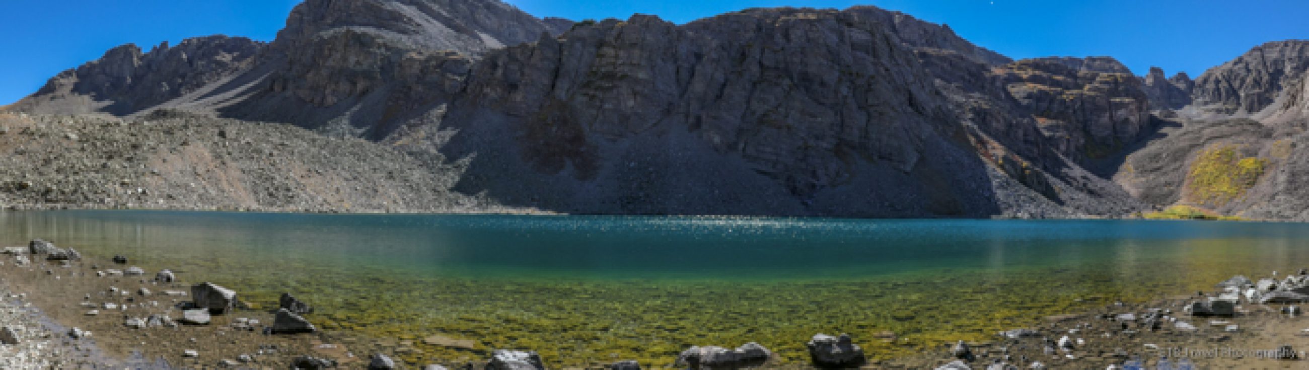
Soon, we beared to the right onto a single-track pathway marked with rock cairns that support tall posts. Along the way, we enjoyed magnificent views of distant mountain ranges. We particularly admired the two red peaks that were a stark contrast to the green terrain. Around mile four or so, we stumbled upon a sheep herder, his dog, and a huge bunch of ewes and rams. A few woolly sheep donned bells that jingled while they trotted away from us as we strolled along the trail.


We continued above treeline for the next few hours as we passed a mountain with a large antenna and a yurt where we considered staying had we gone the backpacking route. Soon we dipped into a marshy area where we slogged through mud. We continued trekking through sludge beneath the cover of the dead forest, destroyed by the Rocky Mountain Pine Beetle. We climbed a series of switchbacks until we left the trees, and remained above treeline for the next seven miles until we completed the segment.


We found Ross and Mike after leaving the trees, exchanged our keys and trail experience, and continued on after a quick lunch break with weather threatening in the distance. We trekked through the high mountain meadow dotted with wildflowers until the sprinkles finally fell. As we stopped, to pull on our rain gear, a fellow hiker asked, “Does it always rain here?”


While we generally get an afternoon thunderstorm, this dreary weather with a constant drizzle sure has been rough. “Not usually like this,” we responded. Dressed in rain jackets and rain skirts (Dusty’s made of a trash bag), we followed a ridge with magnificent views of a canyon below. Marmots made their home nearby, and as we began a steep ascent along the rocky trail we passed by several chirping pikas.


The rain was light for the first thirty minutes and even gave us an hour break as we gained a few miles, but then it began again as we descended the ridge to a grassy saddle just above some ponds to the south. This was when we heard the first clap of thunder.


We had three miles to go which included climbing 500 feet to the highest point on the Colorado Trail (13,271 feet) and was followed a steep downhill on the trail which paralleled a jeep road that passed an old mine and led to the parked car. With enough cover on the southeast side of the mountain and no lightening in sight, we proceeded to the bend. With an unobstructed view of the clouds that were not of the thunderstorm variety and the misty valley below, we kept up our quick pace. While we slid along some mud and were somewhat wet, we made it safely to the car with only having to endure the rain for two hours. This was a much better outcome than last week!


All that was left was to maneuver the 4-wheel drive road that according to the Colorado Trail Guidebook, was “not for the squeamish. It is very steep, rocky, and narrow with many tight switchbacks and some significant exposure.” We added slick mud to the mix too once we knew which road to take! We got to the car that Mike and Ross had left us, and roads traversed in every direction. While we had our databook and trail app, our guide book with directions was in the other car! We were able to see Lake City to the north on the map and confirmed with 4-wheeling folks nearby that the road we wanted was to the right, and off we went!
Ross and Mike beat us back to the campground, and as soon as we arrived they were ready to eat! We didn’t even take off our wet shoes before we headed to Restless Spirits Saloon for pizza. I can’t say it was my favorite and it is only ranked #8 of #13 on Trip Advisor, but the campground lady recommended it. From our perspective, we were really only looking to load up on carbs and protein as we had another big day ahead of us. The best part about the restaurant is that my friend Marissa from one of my tennis teams happened to be climbing a fourteener in Lake City, so she and some of her friends joined us!
Back at the campground and exhausted, I was ready for quiet hour to begin at 8:30pm! I put in my ear plugs and tried to sleep, but I think I just had anxiety about the next day’s hike. We planned to be at the trailhead by 6:30am and would have gone sooner if maneuvering a 4-wheel drive road in the dark wasn’t a factor, but I still wasn’t confident this would give us enough time to get off Snow Mesa, a five-mile stretch above treeline with no shelter from an electrical storm for which the guidebook provides significant warning! This anxiety couple with a bear rummaging around the trash cans at the campground kept me up most the night.
With little sleep, I was dragging at the 4:15am wakeup call. Tents and all packed up an in the car by 5am, we headed toward Creede. It ended up taking us two hours rather than the planned 1.5 hours to get on the trail. The weather proved chilly this morning, though sunny, which was nice to see. We hiked in 1.5 miles along West Willow Creek to San Luis Pass to begin the Segment 21. The trail begins with a steep 1,000 foot gain over a mile to the saddle just under 13,000 feet. Nothing like getting the heart rate up in the morning! The climb took us through many willows and past a variety of wildflowers to lovely panoramic views.


As I trudged along slowly with the view of a car atop a peak nearby, I wondered, why do I do this to myself when I could just drive! Just as soon as we reached the saddle, we carried on to the other side, where we descended 1,500 feet over two miles! This is when I wondered why the trail isn’t etched around the side of the mountain…why all the up and down? Anyway, it was easier to follow our momentum down in a light jog rather than to try to plant our feet to stay at a walk.


As soon as we reached the creek, we climbed back up another steep grade and repeated the process once more until we exited the treeline around 5.5 miles into the segment. For the next 7.5 miles, we would remain above 12,000 feet. Heading up again, we spotted the boys come over the ridge. They looked like they had taken a walk in the park, while we were struggling our way uphill! They had seen grouse and a herd of elk along with the typical marmots and pikas. Dusty exclaimed sarcastically, “We’ve seen three amazing chipmunks!” We had seen pikas too, but that was it.


The boys had gotten on the trail thirty minutes before us, so they beyond half-way when we met them, but we were excited to hear the rest of the way was flat, rolling terrain! Hmmm, as we climbed for the next mile, all-be-it, at a slightly lower grade, I began to wonder what was Mike’s definition of flat! To my relief, after we ascended the next ridge, we could see Snow Mesa below. With clouds in the distance, we stopped for a brief PB&J lunch before we dropped onto the mesa.


Now, with rain in view (ahead and to the left), but no lightning or thunder, we committed to hike as fast as possible for the next four miles. My whistle jingled on my pack as I stepped on and off the rutted trail. Dusty donned her headphones for extra motivation. We really felt like we were zooming across the endless trail that fortunately turned to the right of the black clouds ahead. As I past each post supported by rock cairns, I thought to myself, wouldn’t it be nice if these were evenly spaced. I could count off every quarter mile without stopping to look at my progress on the app.


Unfortunately, this was not the case. They were simply there to mark the trail which I also appreciated. After an hour on the mesa, I finally decided to see how far we had gone. UGH…demoralizing…only two miles!! How could we be so slow?!? We didn’t stop to chat…we just kept going. Dusty suddenly caught up to me when thunder boomed! Fortunately, we only had fifteen more minutes on the mesa when the rain began, and we reached the edge at the second rumble across the sky. We slipped into our rain gear and quickly dropped in below the treeline. Despite the menacing looking clouds, we made to the car after only being sprinkled on for thirty minutes. This was quite exciting and we were very happy to see the road and parking lot below while generally staying dry!


We texted the boys to let them know we’d be in town within the hour. We were certain they were waiting on us. No response. We wandered around and settled on Kip’s Grill for dinner. We still hadn’t heard from them. Dusty tried the satellite phone, but had communication problems due to the weather. Now, we were a bit concerned about them. Was there trouble on the muddy road we drove up this morning? Did they have to duck and cover from lightning? What was up? They were killing time for an hour while their phones were on airplane mode waiting for a response to a satellite phone message they had sent since they thought we were out of range! Eventually we all managed to scarf down some food and make the long drive home. This was a great way to knock out two more segments of the CT, and I definitely want to revisit Creede and Lake City. ETB
Shop
Check out the photographic note cards and key chains at my shop. Each card has a travel story associated with it. 20% of proceeds are donated to charity.


Published by