
Danelle, Nandi, and I drove up to Lake City and camped at the hostel in preparation for our 57 mile backpacking trip which would knock out segments 23-25 of the Colorado Trail over the next 5 days and give us time to make the seven hour drive home with a short hiking day on Monday.
We got to the trailhead around 8 after Danelle maneuvered her SUV over a rough four-wheel drive road. We planned on an easy first day as Danelle had fallen to altitude sickness on this segment the previous year for the first time, and I tend to be prone to it as well, though we exhibit entirely different symptoms!
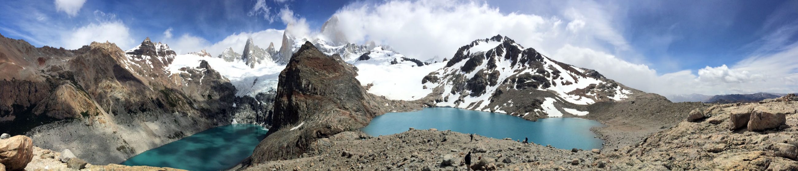
Segment 23 of the Colorado Trail
We started down a jeep road that traveled through the open tundra past remnants of mines until we veered to the right onto the trail after about a half mile. The gradual descent of the single track led us through intermittent willows as we admired the expansive views. Along the way, we spotted marmots, one of which happily posed for us, pikas, and field mice, before we began our first ascent, about 1,000 feet over two miles. The grade wasn’t too bad, but climbing to nearly 13,000 feet with full packs lended itself to slow progress. We were even slower as we stopped to admire lovely wildflowers and interesting rock formations.


Soon we reached the top of the pass only to descend 750 feet over the next two miles where we passed by lovely Cataract Lake to begin our next climb. Then we slogged through the mud before gaining our next rise about six miles into the segment. Upon our ascent, a lovely waterfall came into view which gave us a great excuse for a rest and lunch.


Altitude Sickness and Moose
This is where Danelle felt nauseous and soon vomited. Altitude sickness again, oh no! We needed to get her down to lower altitude as fast as we could, so we turned back toward the trailhead. Nandi and I ditched our packs at the lake as we decided we’d take Danelle to the car and then hike back to camp. It would be easier for Nandi and me to split the weight of Danelle’s pack while Danelle could hike with only her water bottle.
Her nausea returned twice in the six miles back to the car. While the return to the car sucked for us all (and obviously Danelle the most), at least we got to see some moose among the willows which we didn’t spot a few hours earlier. After five miles and mounting 13,000 feet again, I was feeling rotten and had to stop. Nandi took Danelle the additional mile to the car and lucky for them they caught a ride on a dune buggy for the half-mile along the jeep road.


Camping at Cataract Lake
With Danelle at her car, the dune buggy brought Nandi back to the single-track trail where she met me, and we hiked 5.7 miles back over the pass and to the lake as coyotes barked and howled and marmots scampered all over the place. Now, with my head pounding, I was relieved to arrive at camp and hoped I wouldn’t be packing out in the morning!
As clouds reflected in the lake’s glassy waters, a deer trotted through our campsite. What a lovely spot we found! If only the night of strong wind and cool temperatures wasn’t FREEZING! I donned all the clothes I brought with me…two pair of socks, two pair of pants, a t-shirt, a long sleeve shirt, a ski sweater, a down jacket, a wool hat, and mittens. Tucked into my down sleeping bag, it took me hours to get warm, if at all.


Day 2 – Segment 23 of the Colorado Trail
After a fitful night, we arose to find frost on our camelbacks and welcomed the sun that eventually poked through the clouds around 7:30 am. Beginning with the climb where we turned around yesterday, we warmed us up quickly. Unfortunately, the sun and warmth was short lived.
After two enjoyable hours of excellent hiking through high alpine meadows blanketed with wildflowers and dotted with lakes, our luck ended. It was time to zip ourselves into our rain gear as drizzle fell from the cloudy skies. For the next four hours, we followed the trail up and down the ridges as the cool wind blew on our dampened outer shells.


Wanting to save all my layers for another night of high altitude camping, I tried my best to stay warm in my t-shirt and rain jacket. As such, I jogged down the descents, though I expect some people could walk that fast, and I climbed the inclines as fast as possible. Occasionally, I stopped to admire the astonishing landscape with dynamic clouds rising from the lower valleys. We passed by more wonderful wildflowers, though squatting in the rain to snap a photo while trying to keep my lens clear of rain drops wasn’t a first priority.


Camping at the Beginning of Segment 24 of the Colorado Trail
After four hours in the rain and a mile into segment 24, and chilled to the bone, I finally cried, “Uncle”. We’d covered the minimum eleven miles we needed to reach achievable campsites and water locations noted in the databook within the remaining days of our trip. While we would have liked to go further, we found a relatively flat spot (unmarked in the databook) near a creek whose water came from an ice and snow-covered lake just above the trail.
We pitched our tents in the rain and slid into our sleeping bags while we watched it drizzle for two more hours! Finally, some relief came around 4pm. The skies cleared, the sun appeared briefly, and Nandi pumped some water for the morning as neither of us were even hungry for dinner…unusual! I ate a few dry snacks and figured I would pay for it later…about 12:30 am my tummy was grumbling.

Day 3 – Segment 24 of the Colorado Trail
After another restless night, we awoke to clear skies and damp gear. We let the sun dry out our tents a little before we got on the trail around 8 am. I was hoping to leave a little sooner, though Nandi wasn’t in a hurry to leave her warm sleeping bag! We had about 6.5 more miles above treeline with thunderstorms looming based on a two day old forecast, the last time we had cell service.
On this portion of the hike, I was reminded why I suffer through cold nights, rain, and pain. The scenery was simply spectacular! We followed the rolling tundra, again dotted with wildflowers, while we enjoyed panoramic views of the surrounding 13,000 foot peaks and valleys beyond. I think we passed by an alpine lake every half mile to mile.


Soon we reached the trail intersection where we dropped down off the divide into Elk Creek. I’ve never seen anything like it. The path switched back and forth down the open tundra for half a mile. It was so cool to follow switchbacks along a “grassy knoll” rather than through a forest.


We passed by remnants of a mining tunnel and cabin, marveled at more wonderful wildflowers, descended through a majestic canyon, crossed the creek, and welcomed trees! I just can’t even remotely give justice to this area via words or pictures.


The trail paralleled Elk Creek for the next seven miles as we descended toward the railroad tracks. The shaded forest felt like a sauna as the sun heated the wet soil. I felt like I was great a free, natural facial. The path, sometimes rocky and sometimes soft with pine needles (which we wished for more often) provided lovely views. About three miles from the train tracks near a beautiful beaver pond, we started running into several alert, upbeat hikers. They had just arrived on the train and enthusiastically asked, “Where are you coming from?”


With over ten miles under our belt today and about 38 miles in total, I wished I had taken the train! My energy level was depleted, and I felt a little demoralized, knowing we still had four more miles to go, and they were all setting up camp by the pond! Continuing along the creek, we passed the trail to the train stop, and eventually descended to the tracks where we crossed a bridge over the Animas River and trekked to Molas Creek where the water source was much clearer. We found a small campsite tucked in the nearby aspen grove and crammed our tents side by side.


With a pile of wood and a fire ring available, I briefly considered a small campfire, but our tents were too close to the ring, and it started to rain! After a great day of sunshine, we were happy to have our tents up to take cover. Fortunately, the dark cloud moved on, and we were outside cooking dinner and enjoying our nice find…another site not in the databook.
All the way down at 9,000 feet beneath the trees, we looked forward to a warm night’s sleep. I crashed hard for an hour and then awoke hungry. Not eating dinner the other night had caught up to me. All my food was in my bear bag hanging in a tree away from camp. I tried everything to fall back asleep, but finally at 2:30 am, I strapped on my headlamp, trounced across the campsite, untied my bear bag and had a snack! With my tummy full, I managed four hours of sleep.
Day 4 – Segment 25 of the Colorado Trail
This morning, clouds peppered the sky, a sign for rain. We hoped for the best, but expected the worst, as the weather this summer has been far from cooperative though I will say yesterday was glorious! Of course, what comes down, must go up, right? At least in the Rockies. Our hike began with an ascent out of the valley we had descended into yesterday.
Switchbacks took us up 1,500 feet through evergreens and aspen over the next two miles until we exited the treeline. We followed the tundra past a lovely lake to Molas Pass where eventually we got limited cell service and were able to confirm Danelle was OK. She had picked up our Northbound hiker who was helping out with the car shuttle.


We stopped at the pass briefly and chatted with a lady who was visiting her son who attended college in Durango. She wanted to try on my pack to see how much it weighed. I humored her, though warned, “It’s sweaty!” She was giving us so much credit for our accomplisments which was so nice, but compared to all the through hikers, we were pansies. And with only a liter or two of water and almost no food as we were on our last night of camping, the pack was relatively light!
From the pass, we climbed again. Dark clouds rolled in, large raindrops and small pellets of sleet spattered on us as loud claps of thunder sounded in the distance. The storm was headed our way as we hiked as fast as possible across the ridge dotted with single dead trees, clearly once struck by lightning! I was relieved to find the trail was turning away from the black sky and leading us into the clear as we reached the trees. Much to my dismay, the path shifted back toward the menacing weather, but somehow we managed to walk around all the threatening weather and stayed rather dry. And once again, we enjoyed lovely wildflowers.


In the protection of the trees, we stopped for a quick lunch before following the undulating terrain through shoulder-high wildflowers until we finally reached our campsite after 13 miles. It was another great spot, this time designated by the databook, though we never saw the nearby lake. Instead we found multiple creeks, though I imagine at least one of them wouldn’t have been running in regular weather.
Day 5 – Segment 25 of the Colorado Trail
We enjoyed a nice afternoon at camp, cooked dinner, and turned in early as we hoped for a 6:30 am start to finish the last 12 miles and to drive home. I’m not sure if I liked this portion of our hike because I was 12 miles away from finishing what turned into a 70-mile backpacking trip or because the landscape was painted in wildflowers, creeks, and waterfalls.
The sun lit up fields of indian paintbrush, wild geraniums, blue columbine, monkshood and more. The trail led us through rolling tundra as we steadily rose to the top of the 12,500 foot pass where marmots basked in the sunshine. Soon, we dropped back down below the treeline as we crossed several creeks and admired lovely waterfalls. The creeks were especially pretty because the rocks were the color of white chalk, so the water seemed exceptionally clear.


We stopped for lunch by the creek before our final climb which was an easy grade. I reached the top first and stopped in awe. I quietly savored the view until Nandi reached the top, and she simply exclaimed, “Wow!” It was definitely a WOW moment! It was like looking through a kaleidoscope. Yellow, red, purple, and white dotted the grassy valley which was surrounded by mountain peaks that reflected a variety of browns and greens in the sun as the sky slowly filled with billowy clouds. We couldn’t have timed our arrival to the saddle any better. What a great way to end our climb!


With only two miles to go, we picked up our pace, descending through the trees to the car as a few rain drops started to fall. A deer nibbled on grass near the parking lot and lake. All that was left was to maneuver a four-wheel drive road. While it wasn’t terribly smooth, we survived to tell about it! Despite the challenges, it was a great trip and Segment 24 may be my favorite on the Colorado Trail thus far. Segment 5 of the Colorado Trail in the fall is a close second. ETB

Photos are gorgeous!
Thank you!
Beth http://www.notablenotecards.com http://www.etsy.com/shop/nichenotecards http://www.adventuresofacouchsurfer.com http://aroundtown5280.wordpress.com
Sent from my iPhone
>
Sounds like quite the hike! Beautiful pics!