I spent several mornings hiking during my week in Ucluelet and Tofino. Despite the mud, I particularly enjoyed the Canso Bomber Trail, which is a 3.2 mile hike to the crash site of a WWII bomber.
Table of Contents

Paid Parking at Canso Bomber Trail
The Canso Bomber Trail is located in the Pacific Rim National Park Reserve which requires a paid parking pass. For directions, download the trail on all AllTrails as the cell service is limited. When I visited, the machine at Radal Hill didn’t work and a posted sign suggested going to nearby Incinerator Rock or Combers Beach to purchase a ticket.
Canso Bomber Hiking Trail
Much to my dismay, the hike begins on a paved path that runs parallel to the highway beneath the shade of towering trees. Fortunately, this section of the trail is only half a mile, and soon I was ascending through a lush rainforest.
After intermittent rain for the last few days, small puddles donned the well-maintained, gravel packed path lined by Salal bushes and moss-covered western hemlock, Sitka spruce, and western red-cedar trees. The mild ascent led to an old radio building covered in graffiti and clearly a popular place for teenagers to knock back a few beers.


The trail passes around the structure, and this is when the hike gets interesting. Or should I say, it requires attention every step. Covered in tree roots and mud, the undulating trek can be an ankle buster for sure! In all of my hiking in Colorado and around the world, I have never seen so many twisted tree roots on a path!
Luckily, the slow-going up and down terrain soon turns into boardwalks that cross a bog where you can take in some scenery, all-be-it, the forested section is prettier if you have a chance to look up!


1945 Plane Crash Survivors
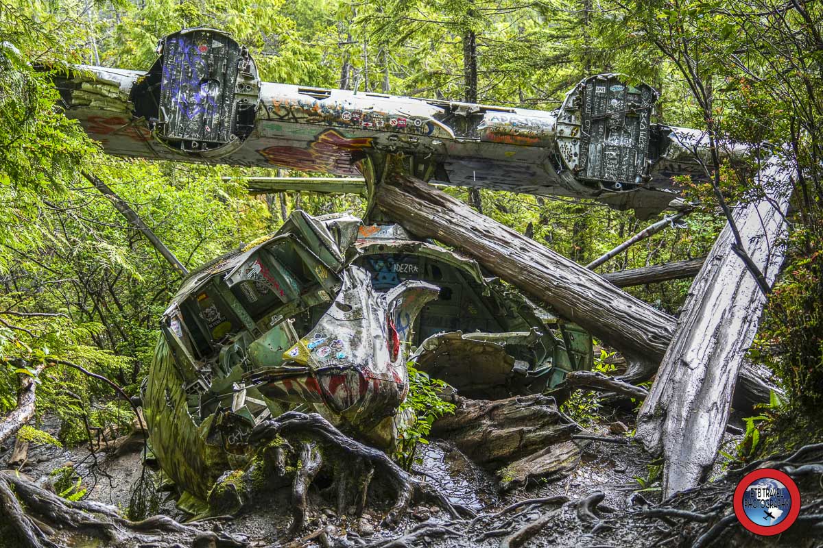
After passing through the bog, the tail of the Royal Canadian Air Force Canso Bomber comes into view. I was shocked to see the 1945 wreckage relatively intact! I was also disappointed to find it covered in graffiti. Without knowing the backstory, I at least hoped taggers were not being disrespectful of a World War II veteran’s grave.
Later I learned, all twelve crew members survived the crash caused by engine failure shortly after takeoff. The crew was flying out on duty from the area as stations such as Radar Hill on Vancouver Island were constructed to keep Japanese attacks at bay after Pearl Harbor.
The bomber, loaded with 3,400 litres of fuel and four 100-kilogram depth chargers, lost power to its left engine, but before crashing into the trees, pilot Ron Scholes stalled the plane to slow its descent. For this reason, the twelve-man crew survived the fiery crash.
Unable to reach the Tofino airfield by radio nor send up distress flares near the spilled fuel, the men spent the night in a tent they made with a parachute. The following day upon hearing a plane overhead, they signaled it with a flare at a safe distance from the wreckage. Eleven hours later, the crew was rescued.
Canso Bomber Plane Crash Site
The army detonated the depth chargers on site, as it was easier than carrying them out, and there is still a six-meter crater today. They also removed the electronics and guns.


Even with the ammunition and electronics gone, exploring around the plane is super cool, especially for a photographer. And while I am opposed to destroying military property, I must admit, the graffiti added to the intrigue. Definitely, walk up and around the entire wreckage, but watch your step at the bottom…I sunk ankle deep into the mud! ETB
Like It? Pin It!

Those forests are dense on the island aren’t they, but what an interesting hike and story. Maggie
I know! I don’t know how bears live in there. Hard to get through all those bushes and roots!!
😅