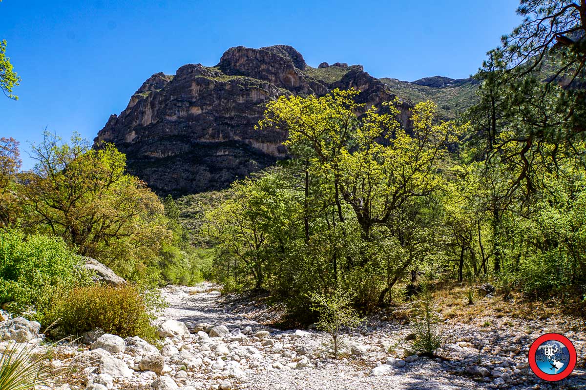
sunrise at guadalupe mountains national park

Guadalupe Mountains National Park: Three Day Itinerary

Guadalupe Mountains National Park is located in West Texas’ Chihuahuan Desert with Carlsbad, New Mexico being 55 miles to the north and Del City, Texas being 44 miles to the south.  Fill up with gas in one of these two cities, as the area is remote.

During my drive through the West Texas desert plains dotted with oil wells, I wondered to myself, why is Guadalupe Mountains a National Park?  I mean, yes, there are some high desert mountains featuring southwestern terrain and lovely fall foliage, but what makes it special?

While the park doesn’t display jaw-dropping scenery like Yosemite, Rocky Mountain National Park, or the Grand Tetons, it is pretty and home to the highest point in Texas.  But the main reason for the 135 square miles being designated a national park is for it being the largest exposed reef in the world!

I had no idea I’d be hiking through the Chihuahuan Desert loaded with marine fossils while exploring historic ranches, admiring cool rock formations, and hiking to the top of Texas.   Guadalupe Mountains National Park pleasantly surprised me.

For those who enjoy hiking and visiting historic sites, plan to visit Guadalupe Mountains National Park for three days and spend at least one day at nearby Carlsbad Caverns. 

EXPLORE!
highest point in Texas, Guadalupe Peak

Guadalupe Peak: The Highest Point in Texas

I’ve been wanting to hike to the highest point in Texas for a while now.  I finally made it to Guadalupe Mountains National Park this past April and knocked out Guadalupe Peak.  I’m surprised I overlooked this National Park when I was visiting Carlsbad Caverns during a year long road trip across the USA.  I was less than 30 miles away from the park that otherwise requires some effort to reach, as indicated by the many “No Gas” sign warnings dotting the highway.

Getting to Guadalupe Mountains National Park

Carlsbad, New Mexico is approximately 50 miles north of the park and the closest public airport to Guadalupe Peak is in El Paso, 110 miles to the southwest.  Definitely come with a full tank of gas and provisions to complete this 8.1-mile roundtrip hike that begins at the Pine Springs entrance.

HAPPY HIKING!

Hiking from Foz d’Égua to Piódão

After hiking 5.1 miles in the Penhas Douradas region of the Serra da Estrela Nature Park the previous day, we enjoyed a leisurely 5th day on our Mountain Travel Sobek hiking tour to historic villages in Portugal. Today, we visited the highest point in mainland Portugal, hiked from Foz d’Égua to Piódão, and dined in an old Palace in Lousã where we stayed for the evening.

Upon leaving Casa das Penhas Douradas, our driver maneuvered our Sprinter Van, complete with USB charging stations, along the winding mountain road.  We enjoyed the beautiful views, while he focused on the two-lane passage.

EXPLORE!
hikers on volta das penhas douradas trail

Hiking Volta das Penhas Douradas Trail

On our fourth day of our Hiking to Portuguese Historic Villages Tour with Mountain Travel Sobek, we spent the morning in Serra de Estrela Nature Park.  Via the Volta das Penhas Douradas Trail, we hiked a 5.1 mile loop to the lake of Vale do Rossime, rather than to a village. 

This was a very enjoyable hike which began from the Casa das Penhas Douradas, a 17-room mountain resort perched at 4,921 feet (1,500 meters). Interestingly, the modern hotel, decorated in natural, local resources, was once a sanatorium.

The sanatorium was constructed after expedition leader and scientist Dr. Sousa Martins determined that Serra de Estrela, with its high altitude and clean air, would be a good place to treat tuberculosis in the late 1800’s.

HAPPY HIKING!

Hike from Idanha-a-Velha to Monsanto

As we continue our tour of hiking to historic villages in Portugal, today we started in Idanha-a-Velha and ended in Monsanto for a 5.5-mile one-way trek.  This picturesque hike was one of my favorites during our six-day adventure.  Photographic opportunities abound in this slice of paradise in Central Portugal.

Idanha-a-Velha is part of the 12 Historic Villages of Portugal Program which the Portuguese government launched in 1991 with the goal of restoring and promoting a series of ancient villages important to Portugal’s history. The villages, located in the Beira interior region of Portugal, include the following:

  • Almeida
  • Belmonte
  • Castelo Mendo
  • Castelo Novo
  • Castelo Rodrigo
  • Idanha-a-Velha
  • Linhares da Beira
  • Marialva
  • Monsanto
  • Piódão
  • Sortelha
  • Trancoso
HAPPY HIKING!
view from rota dos abutres

Hiking in Salvaterra do Extremo

After a few days in the Oeste Region of Portugal touring Óbidos and Nazaré and 36 hours in Lisbon, we finally began our Historic Village Hiking Tour in Portugal with Mountain Travel Sobek.  We began our six-day hiking tour early on a September morning when Ricardo picked up our group of eight and two guides from our hotel in Lisbon.  We drove northeast for approximately three hours until we reached Salvaterra do Extremo.

History of Salvaterra do Extremo

Salvaterra do Extremo is located on the border of Spain and Portugal in Portugal’s central region.  The origins of the historic village date all the way back to the Romans and then later to the Moors.  It became part of the Portuguese Kingdom in the 12th Century.

Its first fortification was likely built when it received a charter from King Sancho II in 1229. Though after the signing of the Treaty of Alcañices establishing Portuguese-Castilian border in 1297, Salvaterra do Extremo was refortified. 

Being located on the border, Salvaterra do Extremo assumed strategic importance.  During the Restoration War in the 17th century, the medieval castle and surrounding town were enclosed with new walls and guarded by the citadel.  While the walls were mostly demolished after the Peninsular Wars, some remnants remain.

HAPPY HIKING!

Wyoming Road Trip

Well, it is that time of year again.  Time to wrap up my summer of van life.  This summer I spent six weeks on the road, most of it in Wyoming.  I really love Wyoming.  It is such a hidden gem.  It’s hard to believe it has the lowest population of the 50 states.  That’s probably why I like it because you get to enjoy the solitude of nature!

Small Towns in Wyoming

I spent the majority of my time in Buffalo, Lovell, and Jackson Hole with a short stint in Red Lodge, Montana, a few days in Cody and Ten Sleep, a day near Pinedale, and a day near Saratoga.  I also enjoyed a brief bit in Denver seeing my family and friends. I drove nearly 5,00 miles, though probably only about half of that was in Wyoming.

I failed to snap my token state sign in costume, but that gives me a reason to go back.  I already have some places for next year as a pit stop to and from Canada.

Of the small towns I visited in Wyoming, I preferred Buffalo.  I loved its quaint downtown, colorful history, the size of the city, and the plethora of outdoor opportunities.  It really stood out above all the other towns except Red Lodge, Montana, which I have previously visited. 

TAKE A DRIVE!

Hiking Lakes Trail

Well, I left Wyoming with a bang!  I couldn’t be happier with my final hike of the summer.  Medicine Bow-Routt National Forest is a hidden gem! I can’t believe I overlooked this place when I lived only 3 hours away in Denver.  The Lakes Trail is fantastic.

Towns Near Medicine Bow-Routt National Forest

The biggest city closest to Medicine Bow-Routt National Forest is Laramie, Wyoming, approximately 45 miles east.  Fort Collins, Colorado is about 1.5 hours southeast and Denver 3 hours.  As a result, day trips are good options, though camping along with mountain cabins dot WY-130.

Additionally, two very small towns flank both side of the forest, Saratoga to the west and Centennial to the east.  Centennial is equipped with a small general store and a restaurant.  Saratoga is much bigger.  It has a gas station, some restaurants, hot springs, a museum, a grocery store, and a nice dog park. 

HAPPY HIKING!
view on pole creek trail

Hiking Pole Creek Trail

Pole Creek Trail is located in the Bridger Wilderness near Pinedale, Wyoming.  It is the main starting point for popular backpacking loops in the wilderness.  As a result, there is a huge parking area, pit toilets, and a basic campground at the trailhead.

After two days of consistent rain, I wondered if hiking the Pole Creek Trail to Elklund Lake was worth it with the collection of people in the trailhead.  It might have been the most people I had seen preparing to hike during the entire month I have spent in Wyoming. That said, it is not like a Colorado 14er or any other popular hikes near Denver when you can’t even find a parking space after 7am.

Additionally, I got a later start than usual and I hiked on the weekend…two things I avoid to enjoy the solitude of nature. Anyway, most people in the parking area were loaded down with heavy packs and were definitely prepping for a backpacking trip.  Donning just a day pack for a long day hike to Elklund Lake, I was able to stay ahead of the traffic.

HAPPY HIKING!