Guadalupe Mountains National Park is located in West Texas’ Chihuahuan Desert with Carlsbad, New Mexico being 55 miles to the north and Del City, Texas being 44 miles to the south. Fill up with gas in one of these two cities, as the area is remote.
During my drive through the West Texas desert plains dotted with oil wells, I wondered to myself, why is Guadalupe Mountains a National Park? I mean, yes, there are some high desert mountains featuring southwestern terrain and lovely fall foliage, but what makes it special?
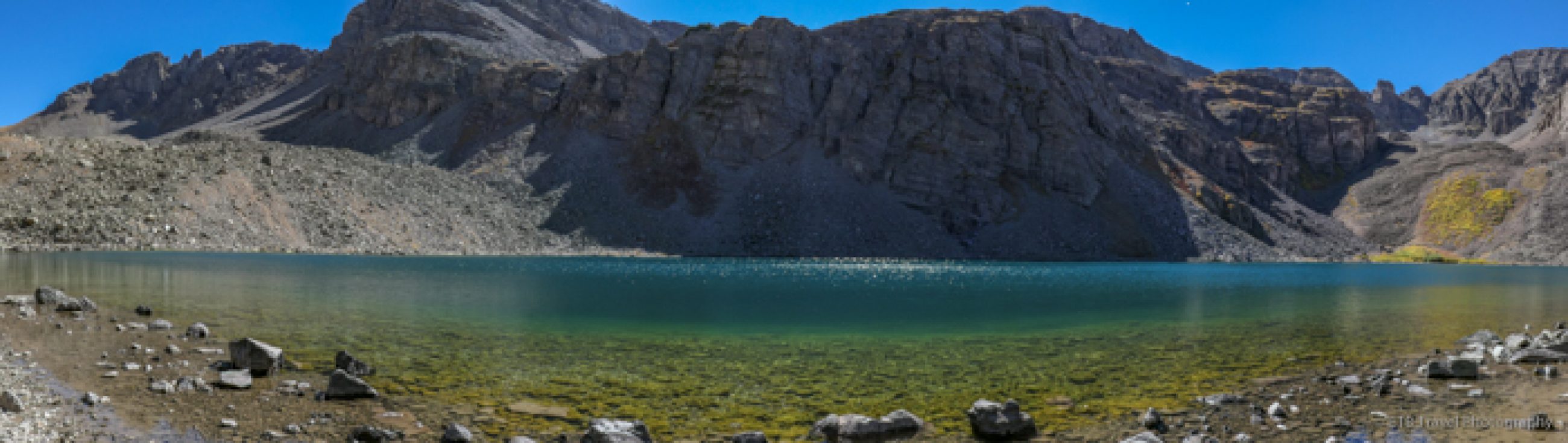
While the park doesn’t display jaw-dropping scenery like Yosemite, Rocky Mountain National Park, or the Grand Tetons, it is pretty and home to the highest point in Texas. But the main reason for the 135 square miles being designated a national park is for it being the largest exposed reef in the world!
I had no idea I’d be hiking through the Chihuahuan Desert loaded with marine fossils while exploring historic ranches, admiring cool rock formations, and hiking to the top of Texas. Guadalupe Mountains National Park pleasantly surprised me.
For those who enjoy hiking and visiting historic sites, plan to visit Guadalupe Mountains National Park for three days and spend at least one day at nearby Carlsbad Caverns.

Where to Stay
The only way to truly stay close to Guadalupe Mountains National Park, is by camping. If you are not camping at Pine Springs Campground, on nearby BLM land, or spending an overnight at the highway rest stop, be prepared to drive 100 miles per day. Fortunately, at highway speeds!
Aside from one hotel in Whites City at the entrance to Carlsbad Caverns National Park, all other accommodations are in Carlsbad, New Mexico. The city of 31,000 caters to tourists and oil riggers alike and has everything you need including a choice of hotels. The Baymont by Wyndham is a good, clean choice. I stayed here my first night before getting my bearings.
When I am touring in VANgo, my Mercedes Sprinter, I tend to only have loose plans and don’t make advanced reservations, so the nearby rest stop suited me during the rest of my late April visit. A handful of people and truckers tuck in behind the nice bathroom building and picnic shelters each night. While there is some highway noise, it isn’t bad for a few overnights.
Campgrounds at Guadalupe Mountains National Park
If, however, you need to park your camper or pitch a tent, you will have to try your luck at one of the Park’s campgrounds or find some BLM land. While there are three campgrounds at Guadalupe Mountains National Park, most of the area attractions are near Pine Springs campground which include 20 tent sites and 13 RV sites which may be reserved at Recreation.gov.
The park’s Dog Canyon Campground is on the remote north side of the park and is a two-hour drive from Pine Springs. For reference, I didn’t even visit that area despite it featuring a waterfall because it is so far.
The group site at Frijole Horse Corral Campground is meant for horses, though theoretically I suppose you could reserve it for the group fee price.
Camping options outside the park include Chosa Campground and Sunset Reef Campground operated by the Bureau of Land Management. There is also a private campground in Whites City.
Spring and fall are very popular times to visit Guadalupe Mountains National Park, so make your campground reservations early.

How to Visit Guadalupe Mountains National Park
For a three-day itinerary in Guadalupe Mountains National Park, I’d suggest spending two days in the Pine Springs area and one day in the McKittrick Canyon area. If you are avid hikers, you could spend more time exploring the 82 miles of trails, but most people are satisfied with popping into the visitor centers, taking a few hikes, and exploring the historic ranches.
I recommend visiting the Pine Springs area first. It is the most active location with the visitor center, campground, several hiking trails, and nearby Frijole Ranch with Smith and Manzanita Springs.
The visitor center features many of the fossils and wildlife which can be found in the park. Rockhounds will really appreciate the geology and fossil displays. I wished I had stopped in the visitor center before my first hike to Devil’s Hall, which is a must-see.
Pine Springs Area of Guadalupe Mountains National Park
While there are many hikes to choose from in the Pine Springs sector, the three most traveled are the Pinery Trail, Guadalupe Peak, and Devil’s Hall.
For your first day in the park plan on stopping in the Visitor’s Center and hiking Pinery Trail, Devil’s Hall, and Smith Spring and Manzanita Spring Loop from Frijole Ranch. On the second day, hike Guadalupe Peak.
The Pinery: Easy
The Pinery Trail is located at the side of the Visitor’s Center. The mostly paved path with interpretive signs leads to ruins of the Old Butterfield Stagecoach Route Pinery Station built in 1858. This is the typical type trail you find in National Parks for non-hikers and is one of the only places dogs may walk. It is short and worth taking a quick journey into history.
Devil’s Hall: Moderate
Both the Devil’s Hall Trail and the Guadalupe Peak trail begin at the Pine Springs Trailhead located at the back of the Pine Spring Campground next to the sign board and pay station.
Devil’s Hall is a good warm up hike for Guadalupe Peak. The four-mile out and back trail follows a path through the cacti, juniper, and cedar for one mile before it drops into a rocky wash without a clearly defined way.
After “scrambling” over boulders, hikers climb up a natural limestone staircase to Devil’s Hall, a narrow passageway guarded by high cliffs fifteen feet apart. The rock formations are a true treat to witness. I highly recommend making time for this moderate trail which takes around two hours to complete.

Guadalupe Peak: Hard
Naturally, with Guadalupe Peak being the highest point in Texas, this 8-mile trail which gains 3,000 feet is the most popular in the park. With lots of loose scree, a few exposed areas, strong sun, potentially high winds, and lots of elevation for Texas, this hike is considered hard. It is best to come prepared, start early, and allow eight hours, though season hikers can easily finish in five. For more details, visit my post, Guadalupe Peak: The Highest Point in Texas.

Frijole Ranch, Manzanita Spring, and Smith Spring
The Frijole Ranch is just a few miles north of the Pine Springs Campground entrance. The ranch is enclosed in a fenced area and has been converted into a museum. Take a few minutes to explore the historic buildings before heading up the path to Manzanita Spring or enjoy a picnic under the shade trees after your hike.
The paved trail turns rocky after reaching Manzanita Springs. Then it turns northwest and gently ascends the cacti laden landscape to Smith Spring tucked in the only other shade on the trail! It’s amazing how water brings life.


McKittrick Canyon Section of Guadalupe National Park
After two days in the Pine Springs area, spend at least one day in the McKittrick Canyon. There is another Visitor Center in this location, 12 miles northeast of Pine Springs, that is open seasonally.
This area has a few trails, though the most popular is the McKittrick Canyon Trail hike to Hunter Line Shack. The well-groomed trail passes through southwestern terrain, crosses a wash and slowly enters a lush canyon where many birds flit from tree to tree.
The 7-mile out-and-back trail features Pratt Cabin, the Grotto and Hunter Line Shack. Anyone that appreciates ranching history will like exploring the Pratt Cabin tucked into an idyllic location beneath the trees at the base of a mountain.

Further down the McKittrick Canyon Trail, there is a turnoff to the Grotto and Hunter Line Shack. The Grotto is an open face of a small cave with stalagmites and stalactites. It is really cool! Just beyond it, is the Hunter Line Shack. This is a nice area for a picnic and a good place to see deer.


If you want more exercise you may continue up the McKittrick Canyon Trail to the “notch”, though the relatively flat trail turns steep for this portion and it is a much longer hike.
Should you have an extra day or you are the fossil friendly type, another hiking option is the Permian Reef Trail. About 30 trail markers highlight the geological history of Guadalupe Mountains National Park, but you will need to purchase a guidebook from the visitor center. This 9 mile trail gains 2,300 feet to a plateau which provides nice views.
Cautions
There are several cacti dotting all the trails in Guadalupe Mountains National Park. I highly recommend pants and a light long-sleeved shirt. The long sleeves will also protect you from sun exposure and keep you comfortable in the likely event of fierce winds!
Also, there is limited cell service in the park and it is smart to download the AllTrails app for maps of the trails that can be hard to follow when hiking through washes.
The park is on MOUNTAIN time. Your phone will likely be wrong!
Finally, beware that the gate to the McKittrick Canyon section of the park opens at 8 and closes at 5 regardless of sunrise and sunset. And please note that the park is on Mountain Time, not Central Time, and it is likely your phone will be wrong!
In all, Guadalupe Mountains National Park is worth a visit. Between hiking, history, wildlife, and geology, there is something for every outdoor adventurer. ETB
Pin It for Later

Looks interesting, especially the exposed reef! When in Alberta you can find shell fossils on some trails and on the mountain faces. The one that comes to mind is Fossil Falls near Upper Kananaskis Lake. Let me know if you want to know more. Maggie
Thanks for the tips! I feel like I need to spend 3 years in Canada, not 3 weeks, but hope to hit some highlights anyway!!
Haha yes, it’s as diverse but larger than the US!! 😊
What a great national park to hike around and great tips for how best to visit there 🙂