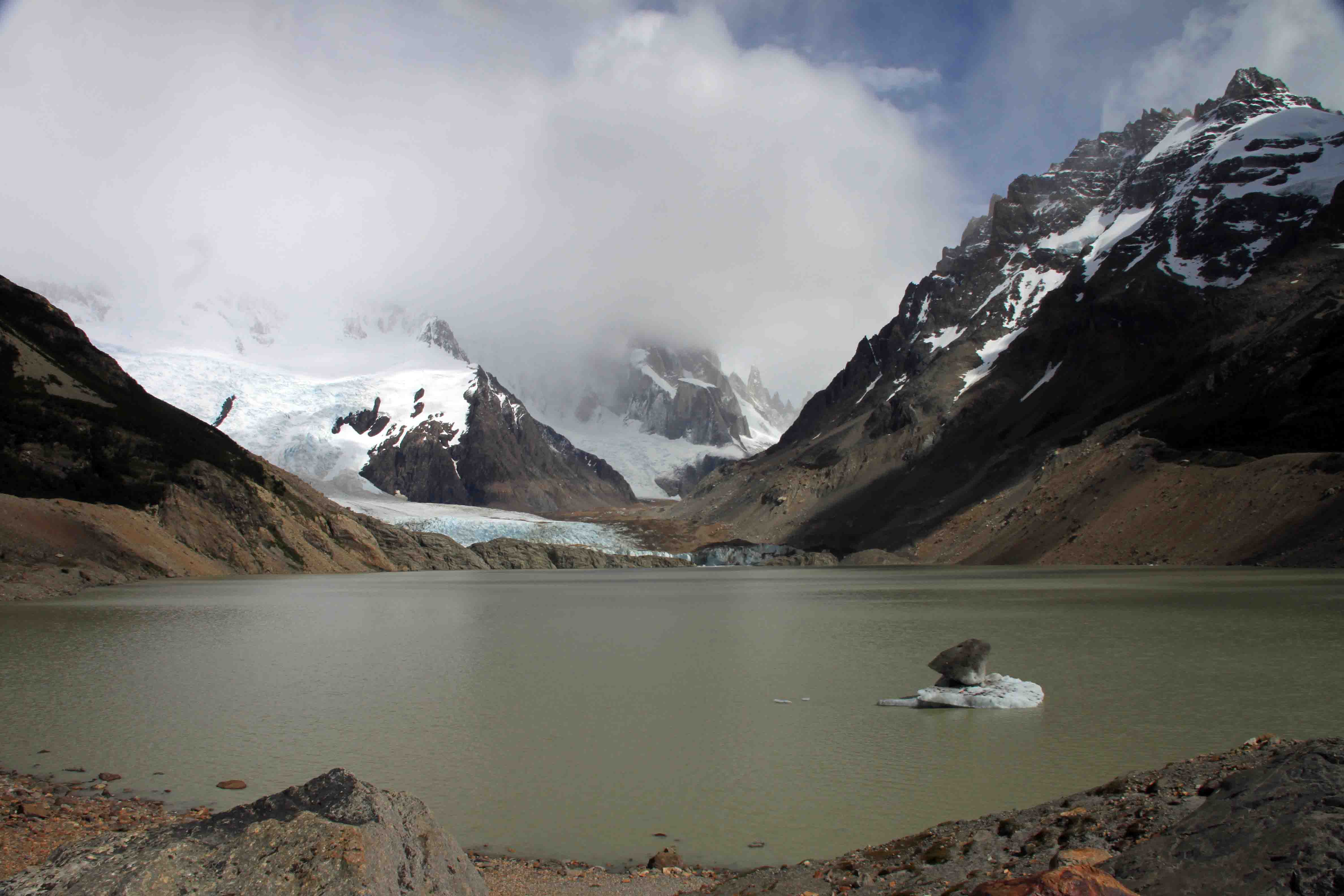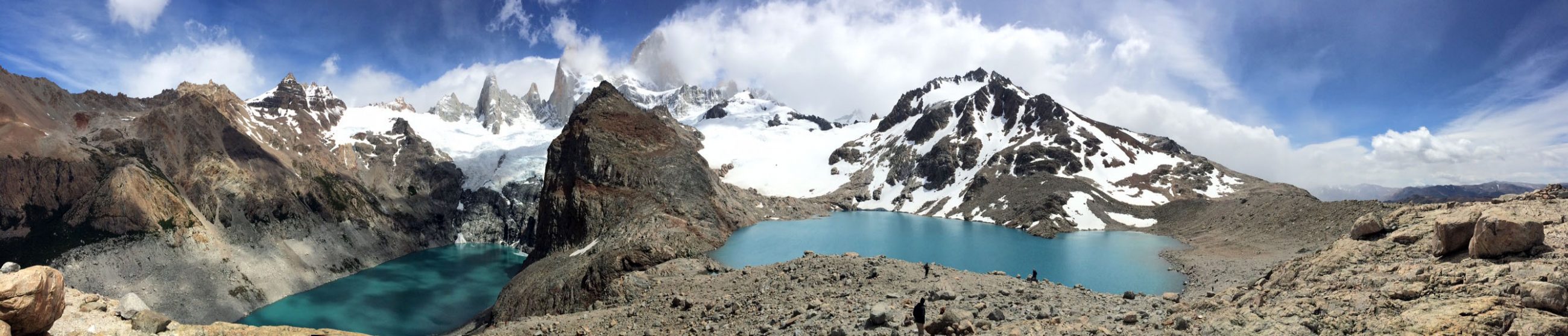
Valle del Francés in Parque Nacional Torres del Paine

We arose early today. It’s not hard to do given it’s light at 5am. The moon lit the sky over the towers briefly before the clouds blew in. We packed up our camp and sat for the traditional South American camping breakfast. Toast, cheese, ham, oats, yogurt and surprisingly eggs that didn’t look like grits (yesterday was the first time we were served eggs for breakfast, but their texture was strange).

We turned in our lunch tickets for a to go box and stuffed it in our pack before we headed toward Campamento Italiano and the Valle del Francés. The wind gusted violently this morning. I was thankful to be following somewhat flat terrain through tall grass and low bushes by the lake so I could keep my balance. Soon we entered a stand of dead trees. It is amazing how well leafless trees block the wind. We turned from cold to hot as the morning sun gleamed on the white trunks. Eventually the dead trees turned to live ones, and we were in and out of stunted forest.

The path was muddy from the many waterfalls that spilled down the walls to our left into the lake on our right. Many of the boardwalks and bridges were in complete disrepair and may have been the only run down thing we’ve seen at the park thus far. Some of them looked rather dangerous. I was careful to walk on the boards with supports beams, and looked for ones that might pop up from being loose. Sometimes I just followed along the side in the mud.

After we made it around the lake and up and over the ridge, we walked through the prettiest forest yet with large trees and soon arrived at a rickety, suspension bridge over an aqua river with a fantastic view of Francés Glacier. This bridge led us to Campamento Italiano which is free and operated by the park. We filled out a form and provided our reservation tickets to the ranger before we seeked a campsite. We didn’t look long because we wanted to climb up to Británico whose trailhead begins at the camp. We found a flat spot not too far from all the amenities (a kitchen and bathrooms which were 80 yards away). Had we scouted at all, we could have found a quieter spot along the river.

We set up our tent quickly, packed up our day packs and followed the trail up the Valle del Francés. Signs pointed us in the direction of Británico. Our walk took us through the campground in the woods and then along a scree path. The gentle sloping path turned steep as we exited the forest to the rocks where we enjoyed a nice view of Francés while eating part of our lunch. We were still at the bottom of the trail, and I was feeling antsy as I wanted to reach the top during the nice weather given it is so unpredictable. Though during our short stop, we did spot another ice calving.

The path, peppered with location signs, crossed countless waterfalls. At times when the trail leveled out, it turned into a small stream. We trounced through the water, climbed over boulders, and wandered through more forest until we stopped again at Francés lookout. Several people had stopped here for lunch as it provided a close up view of the glacier. We didn’t stay long, but kept going toward Británico lookout. We passed through an open space with dead trees, more forest, and more rocky steep areas before we finally reached our resting point surrounded by granite towers and walls a few hours later. What a magnificent panoramic view!

Lucky for us, while slightly breezy, the usually windy lookout point was rather pleasant. We hung out with a handful of hikers for a few hours as we watched the clouds shift. Each set of peaks and walls, once wrapped in clouds soon protruded into blue sky. We sure have been fortunate with the weather! Come late afternoon, we ran out of snacks so we meandered slowly back to camp. Hearing several thunderous booms in the warming day, we decided to make one more stop at the glacier and wait to see ice calve. On the way up, we saw a few poofs of snow. At our final stop, we basically saw a waterfall of ice tumble down the rocks. With that, we finished our descent. After a ten mile day, we chopped up cheese and sausage and complemented it with dried fruit and walnuts for dinner. We were asleep by 9:15! The only disappointment is neither our pictures nor my description can do this place justice. It is so beautiful! ETB

For David’s map and corresponding pictures, click here: map of our hike

Other Articles About Patagonia You May Like

Shop

Check out the photographic note cards and key chains at my shop.  Each card has a travel story associated with it.  20% of proceeds are donated to charity.


photographic note card, barn in colorado
THE BARN
Best Adventure Travel Blog

A Day Off In Parque Nacional Torres Del Paine

So the beauty of reserving camping at Refugio Paine Grande two nights in a row is twofold.

1. In case of bad weather we could choose which day would be better suited for a hike to Glacier Grey

2. We could hike with a day pack, as opposed to backpacking to Refugio Grey on day 1 and backpacking back to Refugio Paine Grande on day 2

It rained off and on from midnight until 11 am. The wind battered our tent. Though the only, single pole alpine tent set up in camp, it survived handily. Since we hiked to Glacier Grey yesterday, we got to take a day off from hiking on a gloomy day. We showered when no one was around, though I would have liked my shower better had it been hot. It was cool with an occasional surge of luke warm water.

During the dreary morning, we played cards and read in the dining area. We warmed up with a hot lunch of lentil soup with salad and bread as we watched the changing weather pattern. Eventually, the sun peaked out. We thought we’d take advantage of the clearing sky to stretch our legs.

We strolled down to Lago Pehoé and found the trail that leads from the park’s administrative headquarters to our campground. This section is part of the Q route. There is also an O route. Both of these routes include the W, but extend to a less crowded section of the park. Having said that, we didn’t find our hike to Glacier Grey to be terribly crowded, especially in the evening.

So we climbed the path to the top of the ridge and admired the landscape from above our campground. On our way down, we saw a woman eating berries. We asked what they were and she replied, “Calafate berries”. We decided to try some, though I didn’t find them that tasty.

Dinner tonight was roast on rice with salad and cream of lentil soup with a terrible dessert and peach juice. After David’s third glass of juice, I said, “You know, I think that juice is straight from the canned peaches that were used for the peach tart last night.” He laughed and replied, “Yeah, and I think the cream of lentil soup is leftover water from the hot lunch that was served today.” Well, at least they aren’t wasteful!

Tomorrow we are headed to Campamento Italiano and Valle de Francés and the forecast seems promising! ETB

Other Posts About Patagonia You May Like

SHOP

For notecards and key chains, visit My Shop on this website.

Mountain Goat Keychain thumbnail

Hiking to Glacier Grey in Parque Nacional Torres Del Paine

Our bunk beds were rough for David. He nearly killed himself before we started the W route in Parque Nacional Torres Del Paine. Still in one piece, we had out breakfast at 6:30am. The lodges are very accommodating for those who leave before the scheduled breakfast time. As usual we got cheese, meat, yogurt, and toast. Eggs would be nice. They put eggs in soup, on pizza, and with a million other things, but not with breakfast.

IMG_3616 breakfast

We shared a cab with two more hikers to the bus station. The 30 minute walk is only a $3 cab ride! We had Buses Gomez tickets that our lodge purchased for us in advance for the 7:30am bus. As soon as it pulled into the terminal we walked outside. This was a brilliant choice. David threw the bags underneath, while I handed over the tickets, and we were the first of five to board the bus and to snag good seats. Being early kept us from waiting for a second bus, though they caravaned together so it didn’t matter too much.

The bus took us past estancias, guanacos and several farm animals during our two-hour transport to the park. We even spotted a grey fox trotting across the hills while waiting a few minutes by a construction site. As the park scenery came into view, at first I was very upset to be sitting on the right-hand side of the bus. Eventually, the road turned, however, and I got to snap some photos.

Several companies operate at the same time. They stop at a small town for a restroom break and soon arrive at Laguna Amarga. Here all passengers must fill out paperwork, purchase park passes, make campsite reservations for free locations, and watch a video on the rules of the park. David’s papers were in his backpack as was the itinerary I made which had the dates for reservations I needed. While I had it memorized, I felt better to have this in hand when making reservations, so we had to do some digging under the bus. I don’t recommend this. Luckily, we were able to get reservations at the free campgrounds when we wanted because some dates were already full. It was amazing that with all the people, no one seems to get left. The buses wait around a while, but it a little chaotic.

I read that we should take the ferry ride for beautiful views so instead of starting the hike at Laguna Amarga, we took the bus to the second stop…Pudeto. Here, we started the line for the 12 o’clock ferry. Boarding the ferry first allowed us to get seats up top for good pictures, however, our bags got stored at the bottom of the pack. I didn’t mind having to wait for our bag, as we had to pay for our $22 one way tickets in cash before we left the ferry anyway. We could have done that anytime during the boat ride, but we wanted to enjoy the view. We felt a like sardines on the ferry, but the spectacular weather made it worth the thirty minute ride across Lago Pehoé.

We had reservations for camping and food at Vertice Patagonia’s Refugio Paine Grande which was located adjacent the ferry dock on the south side of Cerro Paine Grande with magnificent views of los Cuernos del Paine. We checked in, received our laminated food tickets and set up our tent. Fortunately we had our own tent, as tent rentals sold out by the afternoon. The refugio was equipped with mens’ and womens’ bathrooms which included sinks, flush toilets and showers; a kitchen for campers to cook on their camp stoves; a large dining area; a small shop selling limited food supplies; and of course hostel style rooms with bunk beds should guests wish to share a room with strangers and not sleep in a tent.

After getting the lay of the land, I suggested we hike to Glacier Grey today as the last weather update I saw called for rain tomorrow. David was in a more lackadaisical mood until we checked the latest weather forecast with the staff. In Spanish, English, and hand gestures, we learned that tomorrow there would be a chance of rain and low clouds. The gentleman suggested the hike to Lago Grey was only two hours and told us to “go NOW”. Fortunately I had scheduled some buffer time upon arrival at the park because I didn’t have full confidence in the transportation system that they somehow have down to a science with paper tickets!

So we hustled back to our tent, tossed together our day packs and headed toward Glacier Grey around 2:30pm. Just near the turnoff to the trail, I read a sign “11K and 3.5 hours to the glacier”…hmmm. At a quick pace, we followed a light incline up an impressive valley through dead and stunted trees until we reached Los Patos Lagoon. Only 30 minutes into the hike, and we enjoying superb scenery which only got prettier as we climbed. Snow capped peaks towered over the Lago Grey which stretched the entire length of the trail. After about 1.5 hours of hiking, the glacier came into view. It looked magnificent in the nearly cloudless, sunny sky.

We stopped for a brief time to enjoy the grandeur before we continued toward the lookout point by the glacier. This is when we figured out the hike would take three hours at a steady clip as we were going beyond the lake and close to the base of the glacier. The sign and the staff were both right. We were the challenged ones! We had to hurry to finish as we had purchased dinner which ended at 9pm. At least we didn’t have to worry about the light given it doesn’t get dark until 10pm, and we had our headlamps anyway.

While we rushed toward the glacier through intermittent forest, I did not fail to take pictures. Flowers sprinkled the trail and waterfalls tumbled down the mountainside. Soon we reached Olguín bridge not too far from Refugio Grey, also operated by Vértice Patagonia. We passed by the refugio and through the campground to the final lookout point. We climbed out on the rocks, enjoyed a quick snack and view before racing back. Admittedly, I would have liked to enjoy a slower pace, but I also didn’t want to be the last one on the trail or miss our dinner. We capped our hike off by spotting six hares as we descended to our campground.

For David’s map and corresponding pictures, click here: map of our hike

Our cafeteria style dinner was good, though nothing spectacular. The burger patty, potatoes, corn soup, salad and peach tart beat cooking dried camp food. After dinner, we admired an absolutely fantastic sunset that lit up the rocky Cuernos del Paine! We couldn’t have asked for a better day, especially when the clouds blew in just after dark at 10:30 and the rain began at midnight. ETB

Other Articles About Patagonia You May Like

Shop

Check out the photographic note cards and key chains at my shop.  Each card has a travel story associated with it.  20% of proceeds are donated to charity.


photographic note card, belize sunset
SERENITY
Best Adventure Travel Blog

Navigating Puerto Natales, Chile

Our 5:30 bus came after 6 am. I guess that gave us a little more time for our breakfast that the hotel provided to us early. The company blamed the snowy weather. I could see why…we boarded a freezing cold bus with only one windshield wiper. Bundled in our puffy jackets and hats, we thought this will be a long ride to Puerto Natales. Just as we reached the outskirts of El Calafate, however, we met up with another bus and transferred. We gave up our front row seats for heat. I was OK with that trade!

Our bus took us past fields of snow that blended with a white sky. Sheep, guanaco (llama), rheas that look like ostrich, cows and horses peppered the fields that slowly turned green over our five hour drive. The sheep made me laugh because they ran away when the bus passed. They seemed so surprised, but they had to be used to it given all the scheduled bus transportation. On our way, we stopped at Hotel La Esperanza for our rest stop.

We arrived at the Argentinian border, got our passports stamped and then continued on to the Chilean border. In Chile we removed all our carry-ons from the bus, declared any food and passed through customs. The dog sniffed out fruit in our bags and helped agents search the bus baggage storage. The X-ray machine was somewhat useless because the agents only looked at the monitor half the time. We were ready to cross the border, but the bus driver didn’t have his papers! We were stranded 45 minutes away from Puerto Natales. What was funny, is this was the major piece of transportation I was most concerned about going as planned.

We waited a while because the driver said it would be 20 minutes. But after 45 minutes or so, we noticed a guide leading a tour group on our bus started looking for alternate transportation. When they ditched, David went in search of a new ride. A taxi had just pulled up to the border. $30 later, we were racing off the bus, crossing the border and jumping in a cab. It was pricey relative to the buses, but we needed to get cash, stop by the CONAF office, buy our camping food, get our bus tickets to Puntas Arenas upon our return from the W in Torres del Paine, find a park map, and come to find out buy another hat since I grabbed all of David’s stuff off the bus but managed to forget mine!

We checked into Kau Lodge around 1pm, got our room, and reimbursed our hotel $33 in cash for the Bus Gomez tickets to the park that they purchased for us in advance to guarantee us a space during the high season. As much as we would have liked to enjoy their awesome coffee shop, errands called our name. Once again, we had no problem getting cash, despite arriving on a Saturday, so I feel like the Fodor’s book is incorrect given we were visiting over the high season. The CONAF office posed more of a challenge. Our hotel staff guessed its location and was a few blocks off, but it didn’t matter as it is closed on Saturday (but of course it was open on Christmas). We needed to make reservations for some free campsites operated by the park, but it was required to make the reservations in person. We hoped we’d be able to make the reservations upon arrival in the park.

We checked the hours of the grocery store which remained open until 8, so we walked up the hill to the bus station where we purchased our bus tickets to the airport in Puntas Arenas for next week. We actually got to use a credit card for this bus! It seems Puerto Natales is far more equipped for credit cards than El Chaltén. We headed back down the hill for the grocery store. We spotted a few fellow bus mates who told us they were stuck at the border for another hour…not too bad, but aggravating none-the-less. We stocked up on cheese, sausage, pasta, and oatmeal. Outside the grocery store, we picked up some dried fruit and nuts from a street vendor. Next to him, we purchased a hat from a young girl, and then we went in search of a map.

It was just after 5, and we found many stores had closed. Fortunately, we happened upon a hostel that had what we needed. Not only did we find a map, we met an Aussie couple that had just returned from the W route. They said it dumped snow (2-4 feet), it was freezing, two of the routes were closed (Britanico and Torres del Paine), and that people were fleeing to the ferry to leave the park. YIKES…not what we wanted to hear…especially since we opted to leave our microspikes behind in Denver!

Oh, well. After five hours of wandering around town which was much larger than I expected, we returned to Kau Lodge for a coffee and a view of the lake and mountains across the street. We didn’t want to be out too late, so we chose a restaurant mentioned in Fodor’s called Kosten just a few blocks from our lodge. I wouldn’t recommend it. The king crab appetizer that we both wanted wasn’t available, and the service was extremely slow. Our entrees were tasty, though rather small in portion compared to the amounts of food we have been getting everywhere else. At least it had a nice view.

Back at the lodge, we packed up and got ready for our adventure in Torres del Paine with both excitement and nervousness. ETB

Shop

Check out the photographic note cards and key chains at my shop.  Each card has a travel story associated with it.  20% of proceeds are donated to charity.


photographic note card, longhorn
LONGHORN
Best Adventure Travel Blog
lago viedma

Short Hikes Around El Chaltén, Argentina

After walking about 30 miles in the last two days, we considered an easy day of hiking today, especially given the crummy weather. We certainly weren’t going to be able to spot any tall granite peaks in the dreary, overcast skies, so we found some short hikes to enjoy just outside of town in Parque Nacional Los Glaciares.

Morning Hike to Mirador de los Cóndores and Mirador de la Aguilas

Our morning hike took us to Mirador de los Cóndores and Mirador de las Aguilas. Both began at the same trailhead at the south part of town by the park office. We followed the trail up rolling hills with some flowers. As light drizzle fell, we heard a noise in the grass to the right of a trail. We were surprised to see an armadillo! Frightened, it scurried down the path and dug a hole in seconds. Continue reading “Short Hikes Around El Chaltén, Argentina” →

laguna de los tres

Laguna De Los Tres…The Most Sought After Trek in El Chaltén

Hiking to Fitz Roy

Yesterday we confirmed the weather with the hotel staff. Based on a sophisticated forecast system, it was suggested that today would be the best day to hike the Laguna De Los Tres trail for the closest views of Fitz Roy massif. While the trailhead may be reached by walking to the edge of town for an out-and-back trek, it is also possible to take transportation to Hostería El Pilar. I highly recommend arranging a bus/shuttle ride a few days in advance for $125 Argentinian pesos. It provided us the opportunity to see the Hostería El Pilar and the associated trail as well as the Laguna De Los Tres trail. Continue reading “Laguna De Los Tres…The Most Sought After Trek in El Chaltén” →

la cerveceria

El Chaltén…An Awesome Argentinian Town

Traveling to El Chaltén

We returned to the airport Saturday evening to take a flight to Buenos Aires. Things were rather uneventful until we landed in Buenos Aires late that night. We asked the information desk for the name of a hotel closest to the airport for our over night layover. It was suggested to go a new hotel, Hotel Aeroparque. After a visit to the ATM, we took a taxi that drove to a dark area by a parking garage and stopped. We looked at each other nervously and then David asked, “Where’s the hotel?”

EXPLORE!

Great Fun at Great Sand Dunes National Park!

Great Sand Dunes National Park was a site listed in my Reader’s Digest 120 Scenic Drives Book that I used to make my drive around the USA four years ago. Unfortunately, I had to skip this National Park due to required maintenance on VANilla. I was very excited that I finally got to visit the park with David, Heather and Jaz this past weekend.

We made the estimated 4 hour drive in about 6 hours on Friday evening. Rush hour traffic held us up for about an hour, and we had to stop for gas and dinner. Without much light on the road it was difficult to see the turn for the Zapata Falls Campground. After one U-turn, we ventured up the 3 mile dirt road and found one of the last campsites around 10pm. None of us felt like setting up our tents, so the girls slept in the car while David and slept in sleeping bags under the stars. The clear night provided an amazing view of the Milky Way.

The next morning David and I awoke early and drove 24 miles to Mosca Pit-Stop for gas. For anyone who travels to this area, I recommend filling up at the last gas station passed on the way because the area near the park is desolate. Upon return to the campsite, we stopped to admire a small herd of elk along the roadside.

From the parking area by the campground, there is a short trail to Zapata Falls. The trail requires a creek crossing and a little rock scaling, but the jaunt isn’t that hard and the 25 foot falls that careens down the crevasse is certainly worth the visit! What an enjoyable first stop of the day!

Our next stop was deep in the Great Sand Dunes National Park and only accessible by small, high clearance four-wheel drive vehicles. Spots like these is why David keeps his truck around. We passed “The Point of No Return” and followed Medano Pass Primitive Road for 11 miles to Medano Pass. The 11 mile drive through deep sand, a shallow creek (which is deep in the spring and many times non-existent this time of year), and on a rocky road took about 1.5 hours.

Just before the trail to Medano Lake, we found a campsite. There are several campsites along the road which are free of charge and include a bear box for food. Most of the campsites were taken up by hunters, some who erected canvas tents and a small corral for their mules. Rifle season for deer and elk had just begun.

While I would have preferred to have hiked beneath the aspens adorned in golden leaves without gunshots in the distance, the leaf littered trail was still beautiful. We began the hike at 9,600 feet and gained about 1,900 feet over 3 to 4 miles in order to reach Medano Lake. Most of the first two miles followed a relatively easy grade which turned into a steep ascent toward the end. The calm afternoon offered a tranquil lake setting. For anyone with a small, four-wheel drive vehicle who enjoys fall colors, this is the place to visit in late September!

We arrived back at camp after our 7-8 mile hike just before sunset to set up our tents. The nice part about “car camping” is that dinner of ribs, veggie dogs, baked beans, and mashed potatoes is far more gourmet than the typical dehydrated meals we use for backpacking. We topped off our tasty meal with S’mores!

The quiet night turned violently windy around 11:15 am. We could hear the leaves shimmering in the distance a few seconds before the wind whipped through our camp. The fly on our tent shook while the straps held down by our stakes snapped back and forth. David did an excellent job staking the tent down in the hard ground because the corners remained secure. Our fly and mesh tent, however, didn’t keep dirt from raining on us! The sleeping bag was covered in a layer of fine grit! After 3 hours of crazy wind, we could scoop up dirt from the middle of the tent the next morning. But of course, the sand dunes were created by predominant winds and storm winds flowing against each other, so I suppose we shouldn’t have been surprised.

After breakfast, we returned along the primitive road all the way back to Zapata Falls Campground to secure a site for our final night. This was certainly more driving that needed to take place if we were just visiting the park to slide down the dunes, but the park is very diverse with lots of options. Also, David had to leave us this evening, and I didn’t feel like I had the skills to take over the four-wheel driving. Zapata Falls Campground, though not as private as a camp site in the woods, is quite a good deal despite no water nearby. It’s only $11 a night and half price with a National Parks Card.

After securing our campsite, we stopped just outside the park at the Oasis to rent sandboards and sleds. The sandboards and sleds are $21 per person (more on this later). We returned to the park to attack the dunes. Some of the dunes are over 700 feet high. We inquired where to go with the ranger at the entrance station and he said with our truck, we should go back to Medano Pass Road to Castle Creek because a 300 foot dune stands just feet from the parking lot. It only required us to climb up. I can’t believe how long it takes to climb up 300 feet in sand. It was hard!

David, Heather and Jaz all rented sandboards which are wood with foot straps similar to a snowboard. The sandboard was smaller and narrower than a snowboard or the sled that I rented. The sandboard required going barefoot or in socks. On the sled, shoes were optional, but given I had to brake with my feet, I elected to wear shoes. All the boards we rented needed wax. My first recommendation is to climb the dunes without shoes no matter what…much easier! Second, hold the top of the board and shove the bottom of the board in the sand to use it as a post while climbing up…this was a big help.

After probably 40 minutes of climbing beneath a black sky, we finally reached the top for lovely views. The attempts at boarding and sledding down the dune was simply hysterical. I think we had more fun laughing at each other than actually sliding down. Being rookies, we made a variety of mistakes. First, we needed more wax on the boards. David, Jaz, and Heather had a hard time getting them to slide. Second, we probably should have all rented sleds. They go faster and are more fun. Third, we probably should have only rented two sleds and taken turns as after our one attempt, we were exhausted. No one wanted to climb up the dune again! Fourth, in order to get two runs in, we should have gone in the late morning, eaten a packed lunch, and then made another run as the afternoon was nice and cool. Regardless, we had a fun and finished just before sprinkles fell.

We relaxed at the campground in the late afternoon. Jaz built a fire. Heather played the guitar. David and I read. Soon dinner time came around and we made Frito Pie and S’mores! Time to work out again.

The wind overnight was relentless again. It continued through the morning. The girls and I planned to go to the northwest portion of the park to look for elk in the grasslands, but we didn’t realize we’d end up on another unpaved road for several miles. After seeing a Buddhist Retreat Center along the way which was interesting enough, we pulled the plug on driving further and headed home. ETB

Shop

Check out the photographic note cards and key chains at my shop.  Each card has a travel story associated with it.  20% of proceeds are donated to charity.


photographic note card, snowy waterfall in oregon
SNOWY FALLS
Best Adventure Travel Blog