Shelf Lake Trail
The sky was overcast and the morning fog was lifting as I loaded my front seat with my backpack, hiking pole, and camera preparing for my hike to Shelf Lake today. Just as I turned the keys to start the engine, a few sprinkles hit the windshield. Dressed in light pants, long sleeves beneath a fleece vest, gloves, and a knit cap; I thought to myself, I hope the sun comes out at some point or 12,000 feet might be nippy as it was currently in the low 40’s at 8,500 feet.
I had never been to Shelf Lake Trail, #634, so I followed the directions provided in my hiking guide. I turned off Highway 285 at Grant onto Park County Road 62 (also known as Guanella Pass Road). I caught up to a pickup truck that had pulled in front of me who promptly yielded and waved me by. As I rounded the bend 100 yards farther up, I came upon two bighorn sheep; a mama and her baby. They trotted off to side where I pulled into one of the few dirt parking areas that happened to be across from the Burning Bear Trailhead. They couldn’t have been more than ten feet away!
I scrambled for my camera and rolled down my window as the pickup came around the bend which caused them to scamper over a few rocks, but they still remained nearby. The pickup idled, so I thought the guy saw them, but while I was busy clicking on what I figured out was a camera with a dead battery, he was getting out of the truck and aiming his camera at the view the opposite way. I wanted to turn around and scream at him to stop moving while I was changing my camera battery, which I luckily grabbed “just in case”, but the sheep were skipping further down the bend and additional noise would have only frightened them more.
I proved to be an expert multi-tasker: cursing under my breath and changing my battery at lightning speed while keeping the sheep in my peripheral vision. The pickup driver hopped back in his vehicle and drove off sending the ewe and its lamb across the road and clipping over a few more rocks, but thankfully they still stayed in sight. Then I got to enjoy the sheep in the serenity of the fall morning on the mountain top all by myself. It was spectacular!


After snapping a few photos of the uncooperative pair (one always looking up while the other was looking down or turning its butt toward me), I continued on for the described 6.6 miles; though, I didn’t reach a turnoff for a Campground. Shortly thereafter, I saw a dirt road to my left where I turned off into an open field which was marked by a government, recreational sign. I followed this road through the meadow to a horse corral and a camping area, but the mileage described in the hiking book didn’t coincide with the road I was following, so I turned around. I thought maybe I had missed the turnoff, so I back-tracked a short distance to no avail, and decided I’d just see what other trails were by the Abyss Lake Trailhead, as I had seen several trails nearby the main parking area. All of them claimed to go to the Abyss Lake which I had hiked last week, so as I looked closer at the map, I noticed there were two turnoffs by the Geneva Park Campground, and I thought to myself, perhaps I didn’t go far enough despite going 6.6 miles according to my odometer. It turns out, I hadn’t. Just a fifty feet further, there was another turnoff, that was clearly marked Geneva Park Campground and Duck Creek Picnic Ground. I certainly had made it too hard…blame it on a faint headache.
According to the directions, I was to follow the turnoff 0.3 miles to the entrance sign at Geneva Park Campground and then continue on FDR 119 2.8 miles to the trailhead. The road, while not designated at a 4-wheel drive road, has several rocky patches so we (me and my car) bounced at an extremely slow pace dodging a few dips and the most pointed rocks as I didn’t want to end up with a flat tire in an area without cell coverage. I’m not sure what gave me the hardest time, negotiating the road while looking for the trailhead and keeping an eye on the odometer or simply if I had marked the odometer from the wrong sign at the entrance because I could not find the trailhead!!! My multi-tasking had gone to crap!
I saw a blue diamond on a tree, so I was convinced this was a trail, but I couldn’t find a trailhead anywhere. So, I drove up a little further thinking it had to be close by. I found a path that was about the width of a logging road that looked to have some mountain bike tracks, but the area just didn’t seem right and there weren’t any signs. According to the map and description, the creek should have been very near the road I had been crashing along and the trail should have followed the Smelter Gulch drainage.
Maybe I was just willing the trailhead to continuously be around the next bend because I was tired of my jarring journey! I felt like I had been driving for hours. In fact, I probably had. I certainly wasn’t going at rocket speed for the last 3 miles. I looked at the map again (not a pinpoint accurate driving map, just a grayscale picture of roads and trails in the area) and continued a bit further, when a head popped up from behind the willows. At first glance of the large brown body, I thought, oh an elk. I had missed a few good pictures when I stumbled across some elk two weeks ago, so naturally this time I was racing for camera in my passenger seat and maneuvering my car for a view between the bushes to get some shots of the enormous cow and her calf. I captured a few moments as they meandered off toward the beaver pond, but each shot seemed to have a leaf or branch in the way.


So, I pulled to the right side of the road as they continued off to the left. I slowly got out of my car and crept down behind the willows to start shooting some unobstructed shots when I thought to myself, those elk didn’t have a triangular face, it was more rectangular. And their withers protruded high above their backs. Then I realized and am embarrassed to admit they were MOOSE! Don’t say BLONDE to me!!! They would have had to come a long way across a beaver pond to stomp me, but I must say I’m not sure what world I was in for a couple of minutes. Talk about distracted…I’ll blame it on the headache again! It was so exciting though. I was just not expecting to see a moose. I know they are in Colorado, but they are elusive none the less!
By this point, I didn’t know whether to sit there and watch the moose the rest of the morning, continue to look for the trailhead, or to round up the few campers I saw and shout: moose, moose! I still couldn’t believe my eyes, so I opted out of telling anyone else and decided to continue my search for the trailhead. I finally came upon the creek that actually crossed the road! Now I knew I was at the right spot, but I still didn’t find a trailhead sign, and all the trails I’ve hiked in the area have included a map and a sign. The book even described the trail as established the entire distance, so it had to be obvious, though the markings for another trail in this area weren’t fantastic.
At this point I was quite certain I was in the general area of the trail which was supposed to follow the creek. As a kid, whenever we followed a creek, we were told if we ever got lost, follow the creek back the opposite way. With this in mind, knowing there were five creek crossings, and my gps claiming we were 9,900 feet which is was the beginning elevation according to my book, I thought I’d walk up along the creek for a while and hopefully stumble across the trail. Given the amount of shotgun shells lying around, I figured someone had fun shooting the sign.


I followed a narrow path beneath the pines that led to a wider one, but the path continued up steeply. The description of the hike was easy and the first mile and a half the trail was to climb steadily. So far, I didn’t have the greatest feeling, but knew I could find my way down and continuously turned around taking in views and even snapped photos. I hardly hiked much at all when I decided, this was for the birds; the wider trail leveled out to a light path that was hardly distinguishable, thus I turned around and ten minutes later was back in my car and throwing in the towel for the day.
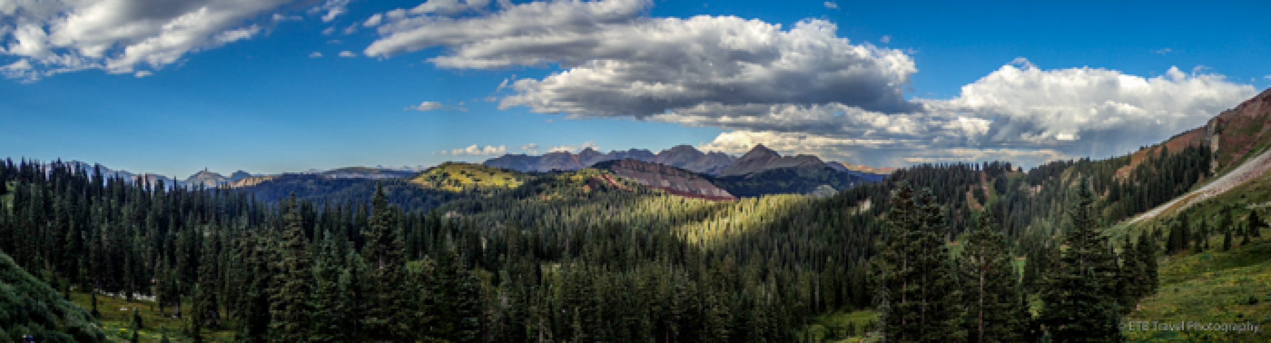
I four-wheeled back across the creek and decided that I would at least explore the side of the creek I had just come to as well. I wandered around the remnants of old campgrounds, found what looked like an old mine shaft and then realized why this was called Smelter Gulch drainage when I was looking at a pile of mined rocks. I climbed up the hill a hundred yards or so and bounced to the right a couple of times, and low and behold, I found an established trail! I followed the trail down to the road and found a small 6×12 inch sign tucked in the trees and out of sight from anyone who is driving in from Park County Road 62, which I believe is the only way to reach FDR 119. My head needed to be on a swivel! Now that I know where the trailhead is, I might try hiking to Shelf Lake tomorrow. On my way out, I checked my odometer, and the trailhead was 3.1 miles from the campground entrance sign, not 2.8 miles which doesn’t seem like much unless you are driving 5 mph. Despite missing out on the hike at Shelf Lake Trail, I had a wonderful day enjoying the wildlife and just exploring the area and enjoying the views and falls colors. While some aspens are bare, many are still holding their golden leaves. ETB
Shop
Check out the photographic note cards and key chains at my shop. Each card has a travel story associated with it. 20% of proceeds are donated to charity.

