What a lucky ten days I’ve had, starting with a random act of kindness when a gentleman approached me on the sidewalk near my drive way and asked for a few minutes of my time to give me a DVD of a movie, to the rain gods blessing our girls trip to Mt. Elbert providing the best two days of weather we’ve had in the mountains for the last two months, to stopping off at West Side Books (as they carry my photographic notecards) on my way home to pick up a small gift only to get a book for free! I’m not usually a horoscope reader, but with all this luck I read my June/July horoscope by Susan Miller after the fact, and she was right on!
This is the sixth year, our fearless leader Karla, has organized a sojourn to climb a 14er. It began as a celebration for her 40th birthday, though she hasn’t reached the tender age of 46 yet. Last year was my first year to participate, and as soon as the date was scheduled, I was signed up again this year. As always, the trip includes repeater hikers and new faces. The only restriction is, “women only.”
This year the trip included first timers; flat-landers from Kansas, Ohio, and Pennsylvania; and seasoned veterans from Denver. About twelve of the 28 girls, the largest group yet, planned to meet in Leadville for lunch at High Mountain Pies. Most of the drive to Leadville was through a sprinkle, a drizzle, or a solid shower, as our wipers cleared the rain and road water away from the windshield.
The restaurant was tiny with only a few tables for indoor seating, though the fenced in backyard was enormous. With the sky overcast, the tables soaked in rainwater, and the temperature a cool 50 degrees, for a few minutes we debated whether we should find another lunch spot, but the pizza smelled divine and the bathroom called our names, thus we ordered.
It turned out to be a good decision to stay.


The staff quickly squeegeed the outdoor tables and soon thereafter the sun poked through the clouds! To top it off, the pizza was superb. No sooner did we finish lunch, did it start to sprinkle. The mountains, covered in dark clouds, looked even worse. As such, we made an executive decision to stroll around town instead of looking for and setting up camp in a deluge. After browsing though an antique shop and a second hand store that had some useful winter gear for a few of our flat-landers, we warmed up over a cup of coffee as the skies cleared.
The mountains came into view, so we caravanned to the Mt. Elbert – Northeast Ridge Trailhead located five miles down a relatively decent dirt road lined with several campsites leading to Halfmoon Creek. Karla always likes to know where the trailhead is before we search for a campsite. Jess and Nilou left us at the trailhead parking lot, while they scoped out a campsite. They returned in record time with a great spot just a ¼ of a mile down the way. They promptly claimed, “The site found us. It was the only one available.”
It was a great site for us, as with 28 girls, we probably had 15 cars, and we were located across from the overflow parking area for the Mt. Elbert Trailhead. While “No Camping” was allowed at the trailhead, no signs were posted at the overflow area; therefore, we essentially had two spots next to each, of course one was much more picturesque than the other. While there were many amazing things about camp, the best may have been that it had stopped raining! Some girls pitched their tents beneath trees, while others prepared to sleep in their cars. We wandered around enjoying the creek that gurgled along-side our awesome site. With a lot of patience, brown paper bags, and pine needles, we finally got the wet wood to burn into a toasty campfire.


Soon the rest of the group trickled into the San Isabel Forest. Karla prepared an excellent carb-load dinner – cold pasta with shredded chicken, cabbage, snap peas and asian dressing. We formed a circle in our camp chairs around the fire, each us taking turns explaining how we ended up on this amazing adventure!
4:30 a.m. arrived early, though I don’t many ladies slept well. It was a cold night camped at 10,000 feet. Our packs were stuffed with rain gear, cliff bars, sandwiches, chips, fruits, dessert, water, and Andrea even brought a flask of whiskey to celebrate summitting the highest mountain in Colorado at 14,433 feet. The Mt. Elbert – Northeast Ridge Trail is rated Class 1 (the easiest), begins at 10,040 feet, and gains 4,700 feet (because it goes up and down) to finally end at the top of the second highest peak in the 48 contiguous states. The roundtrip hike is nine miles.
We started on our 9 miles around 5:15, a few minutes later than planned, though relatively timely given we were rounding up 28 girls…that’s sort of like herding cats. Dressed in multiple layers, ski caps, and gloves, we donned our headlamps, and ventured up the trail in the dark.


The rocky path ascended immediately and veered to left at the Colorado Trail Junction. We individually crossed a make shift bridge across the shallow creek and continued up the trail through the lodge pole pine forest as the orange glow of the sunrise glimmered above the low lying clouds and behind the mountain range.


We followed the switch backs until we reached a flat portion of the trail surrounded by a green ground covering and pine forest to which I commented to Tanya, “I’m really enjoying this part, but that only means we’ll have to gain all the elevation over a shorter distance.” This comment will come into play later.


We hiked for about 2.3 miles through the forest up wood and rock steps before we finally reached the tree line. This steep section stretched out the group as some of the flatlanders struggled with altitude sickness despite acclimating for a week and the super fit zoomed toward the top without a picture while the rest of us filled out the middle. Upon leaving the trees, we enjoyed a magnificent view of the cloud filled valley with the sun gleaming overhead. The fallen trees that lined the trail were blanketed in frost. A twisted one looked like a brown and white candy cane.


After several photos, we followed the path as it zig-zagged through the tundra. With all the rain, I was expecting to see a bunch of wildflowers as they have been magnificent this year, and we saw tons last year on Mt. Yale. Unfortunately, the flowers were lackluster.


Slowly, the tundra turned to rocks and the path began steepening again. Marmots sunned on the piles of stones as pikas chirped and scampered beneath them through their tunnels. It took forever to finally find one. One with calico markings poked its head out of its hole right by the trail that followed the ridge in a very steep section up to the first false summit. By this time, I had stuffed my good camera, with my heavy lens into my backpack, so it wouldn’t be smacking into the rocks as I leaned forward and lumbered up almost vertical trail.


I have to say, the trail was extremely well maintained and for the most part was smooth. We finished one steep portion in order to earn a 30 foot flat segment and geared up for the next steep section. Is there another word for steep? I can’t imagine the grade. A few times a felt like I was going to fall backwards. My feet slid. Occasionally I stepped sideways or backwards to keep my balance, though admittedly, there wasn’t any loose shale which was nice! I think my problem was the lack of soccer. Having quit in January and not supplemented my exercise with any other kind of cardio, my lungs and legs were challenged, but for the first time ever, I started out hiking a 14er without a headache, so I had that on my side, though I felt one coming…it was only a matter of time.
With the sharp incline, this part of the path was a doozy and we spread out even more. Tina zipped past us. Tanya and I hiked together. Others lagged behind. We could see the next false summit. I wondered out loud, “How many false summits are there?” as I heard the girls saying there were many. This false summit was the one we could see for much of the hike, and it turned out to really be the only one. The last one hundred feet to the rock pile cairn, I walked at a snail’s pace…that’s what my headache, the thin air, and legs whose muscles didn’t feel like they wanted to flex did to me. I turned to Tanya, “Am I going too slow for you?” “A little,” she responds as she passes me. She nicely waited for me, as once we reached this flat area, we could see all those who had summitted and we only had a short distance to cover. We could summit together in a few minutes!
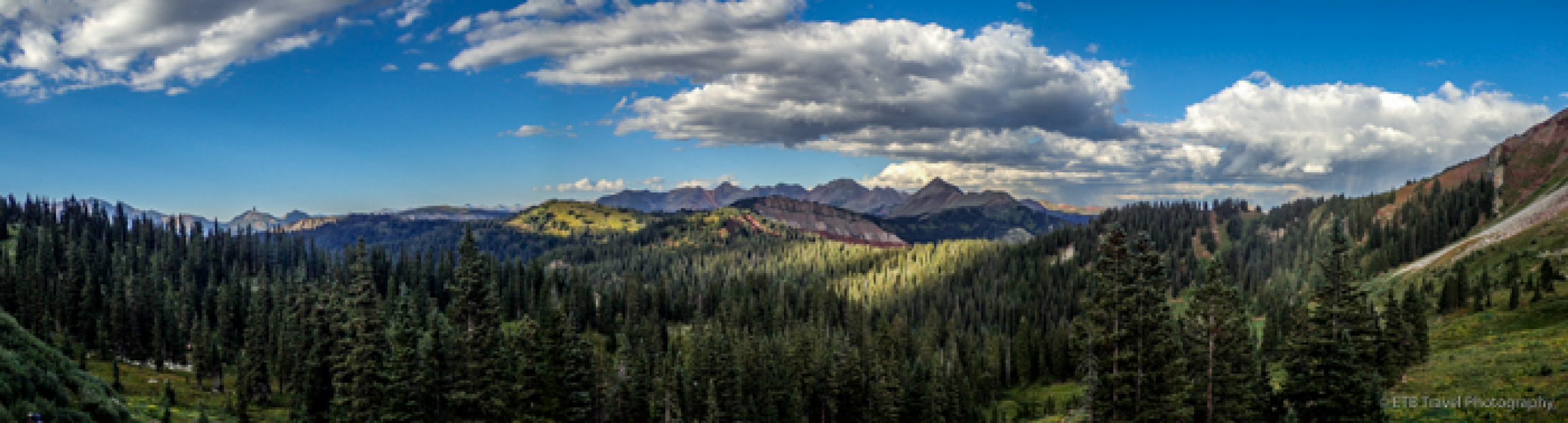
That sight was the most encouraging sight of the day. With an added zip in my step, we topped the mountain 4 hours and 15 minutes after we started! We joined four other girls from our group that had been resting on the far side of the summit for the last 30 minutes and Tina that had reached the peak a few minutes before us. It was an absolute pleasure to be able to sit on the highest point in Colorado and not freeze to death. Oh what a glorious day…clear skies and no breeze!! The panorama offered views of Twin Lakes as the low clouds has dissipated, all the 14ers that were below us, and more. We snacked, snapped photos, napped, and celebrated each time more girls joined us.


Of course, everyone up there congratulates everyone else. There isn’t a stranger on a mountain summit. Posters are passed around to use in photos. The log book is signed by all. Climbers search for the survey marker. It’s exciting no matter what, but it’s more exciting when a couple from the group gets engaged! Congratulations Sarah and Joyce!! They overslept an hour, so we weren’t up there to see the proposal (shucks), but what a perfect day for them!
The first group of girls descended after an hour on the summit. Tanya and I spent almost 1.5 hours soaking in the sun before we started down. Cindy and another Sarah joined us. We encouraged the girls still ascending as we were slowly picking our way down the trail. My bladder really wished I had the ability to hike down a trail quickly. Much to its dismay, I go almost as slowly down the mountain as I do up and the tree line was a terribly long distance away!
On our descent, we found two of the Kansas girls at the first “false summit” enjoying their lunch. They said, “We’re starving”. I bet, I thought. I had to eat goldfish as I exited the tree line and half of my peanut butter sandwich just as I was beginning the last steep ascent and that was hours earlier. It’s amazing how many calories are burned just on a hike. It’s also amazing how much a body physiologically changes due to altitude or relative lack of oxygen. Those of us that live in Denver have the advantage of extra red blood cells.

We finally made it to the tree line which surely seemed like forever. Cindy and Tanya waited on me while Sarah went on to the campground. With the sun blazing overhead, though just about to enter the shade of the forest, we debated whether to shed some more layers. We did. Tanya also changed her shoes while I shortened my pants to crop length…both good choices.
We entered the forest, descended the stone steps, eventually made it to the smooth, flat trail, descended the wooden steps and finally made it to the split in the trail with the Mt. Elbert sign. Whew…only a mile to go! Thank goodness, as I had just sucked dry my camelback. The last mile seemed like forever though I think it’s because we didn’t remember what we hiked in the dark very well. Soon we crossed the creek, stopped at the restrooms at the trailhead, and headed back to camp. We had finished climbing Colorado’s highest mountain in just around 7 hours after having spent at least 1.5 hours piddling around enjoying one of the best summer days I’ve ever had on a 14er.


We chilled at the campground while we waited on everyone to finish up. Twenty-six of the twenty-eight summitted…not too shabby. Our day and night wasn’t complete yet. One of the reasons Karla picks a 14er in the Collegiate Peak range is because it is near Mt. Princeton Hot Springs. We checked into our three cabins and most of the girls enjoyed the warm spring pools. I was probably one of the few, if not the only one that stayed at the cabins but didn’t go to the hot springs. They just aren’t my thing, and my headache seemed to come and go all night…on for an hour, off for an hour, but amazingly I felt better than I normally do, though I guess that’s not saying much. As I said to Karla, “I’m not sure why I torture myself.” And she replied, “It’s that 14er bug.”
She’s right. There are so many feelings that go along with climbing a 14er. The mind over matter comes into play. It’s a competition with yourself. There’s sense of accomplishment. Of course there is all the nature and beauty the earth has to offer. Then there is the sense of camaraderie. Many of us don’t know each other at the beginning of the trip, but we are all rooting for each other to make it to the top. And as I mentioned before, there isn’t a stranger on the summit…human kindness at its finest form shines like the sun. It’s just a good competitive accomplishment.
So after the hot springs, everyone retired to their respective cabins, ate dinner and played games. Ours included bacon and cheese brats with pasta salad, grilled veggies, cous cous and more. We capped off dinner with Cards Against Humanity. I turned in early along with four others. Since I had the couch, those who wanted to stay up past ten went to another cabin. I didn’t hear about any end of the night festivities as I left early to say “hi” to my brother and sister-in-law at Estabrook and to prepare for my sleep study. I’m certain the girls went back to the hot springs this morning, and my guess is Tina taught a yoga class to stretch some of those kinks out of our bodies. I’m so thankful Karla organizes this trip, as I know it is a pain, and I can’t wait for Mt. Massive next year!!! ETB
Shop
Check out the photographic note cards and key chains at my shop. Each card has a travel story associated with it. 20% of proceeds are donated to charity.


You must be logged in to post a comment.