A Day Off In Parque Nacional Torres Del Paine

So the beauty of reserving camping at Refugio Paine Grande two nights in a row is twofold.

1. In case of bad weather we could choose which day would be better suited for a hike to Glacier Grey

2. We could hike with a day pack, as opposed to backpacking to Refugio Grey on day 1 and backpacking back to Refugio Paine Grande on day 2

It rained off and on from midnight until 11 am. The wind battered our tent. Though the only, single pole alpine tent set up in camp, it survived handily. Since we hiked to Glacier Grey yesterday, we got to take a day off from hiking on a gloomy day. We showered when no one was around, though I would have liked my shower better had it been hot. It was cool with an occasional surge of luke warm water.

During the dreary morning, we played cards and read in the dining area. We warmed up with a hot lunch of lentil soup with salad and bread as we watched the changing weather pattern. Eventually, the sun peaked out. We thought we’d take advantage of the clearing sky to stretch our legs.

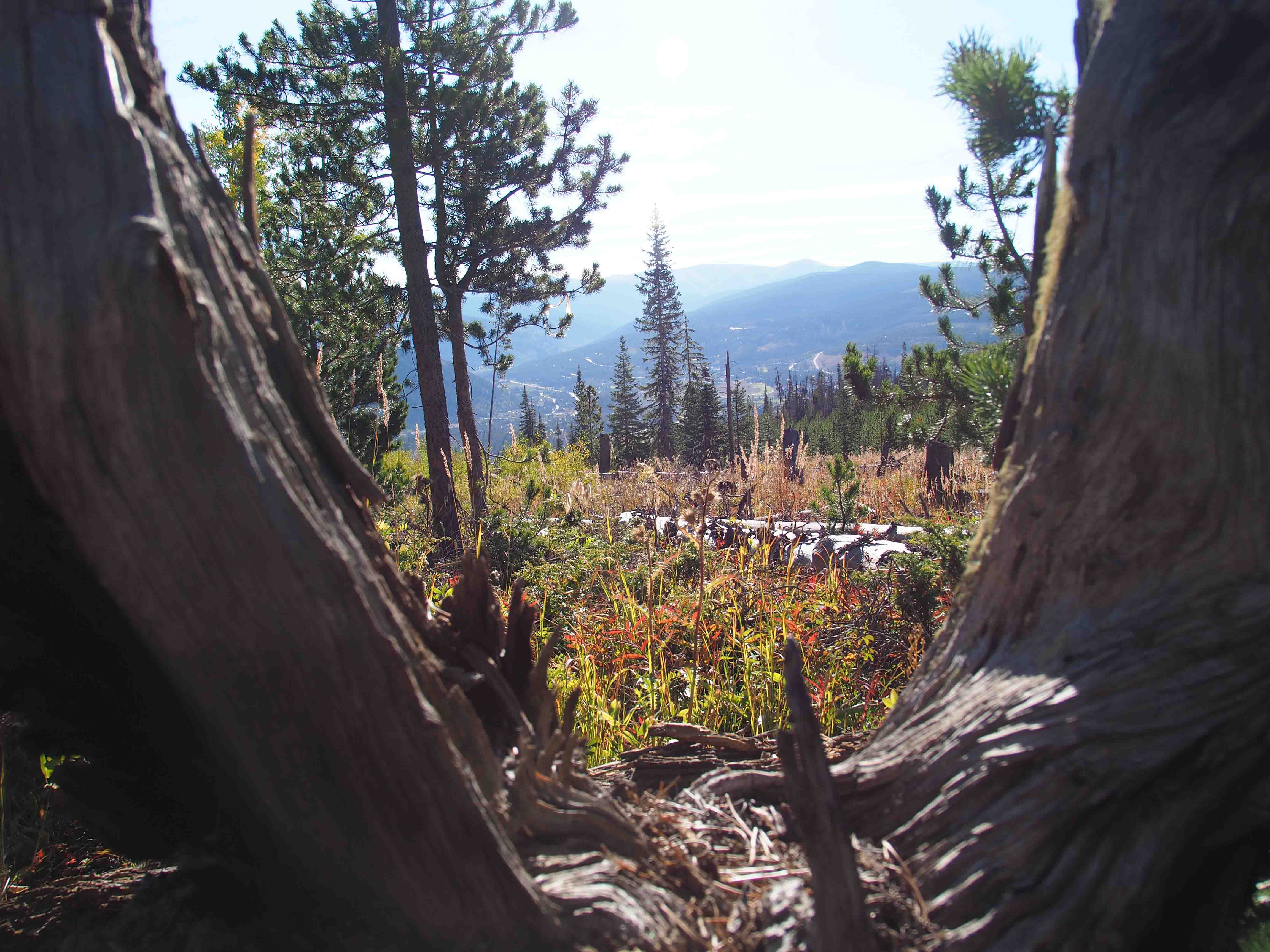
We strolled down to Lago Pehoé and found the trail that leads from the park’s administrative headquarters to our campground. This section is part of the Q route. There is also an O route. Both of these routes include the W, but extend to a less crowded section of the park. Having said that, we didn’t find our hike to Glacier Grey to be terribly crowded, especially in the evening.

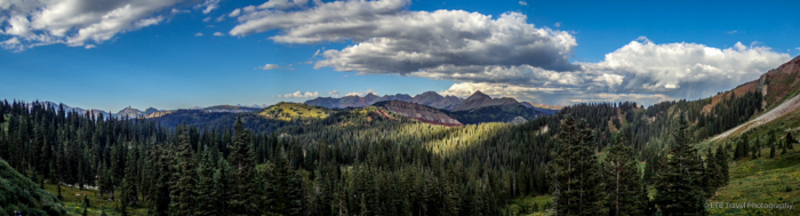
So we climbed the path to the top of the ridge and admired the landscape from above our campground. On our way down, we saw a woman eating berries. We asked what they were and she replied, “Calafate berries”. We decided to try some, though I didn’t find them that tasty.

Dinner tonight was roast on rice with salad and cream of lentil soup with a terrible dessert and peach juice. After David’s third glass of juice, I said, “You know, I think that juice is straight from the canned peaches that were used for the peach tart last night.” He laughed and replied, “Yeah, and I think the cream of lentil soup is leftover water from the hot lunch that was served today.” Well, at least they aren’t wasteful!

Tomorrow we are headed to Campamento Italiano and Valle de Francés and the forecast seems promising! ETB

Other Posts About Patagonia You May Like

SHOP

For notecards and key chains, visit My Shop on this website.

Mountain Goat Keychain thumbnail

Great Fun at Great Sand Dunes National Park!

Great Sand Dunes National Park was a site listed in my Reader’s Digest 120 Scenic Drives Book that I used to make my drive around the USA four years ago. Unfortunately, I had to skip this National Park due to required maintenance on VANilla. I was very excited that I finally got to visit the park with David, Heather and Jaz this past weekend.

We made the estimated 4 hour drive in about 6 hours on Friday evening. Rush hour traffic held us up for about an hour, and we had to stop for gas and dinner. Without much light on the road it was difficult to see the turn for the Zapata Falls Campground. After one U-turn, we ventured up the 3 mile dirt road and found one of the last campsites around 10pm. None of us felt like setting up our tents, so the girls slept in the car while David and slept in sleeping bags under the stars. The clear night provided an amazing view of the Milky Way.

The next morning David and I awoke early and drove 24 miles to Mosca Pit-Stop for gas. For anyone who travels to this area, I recommend filling up at the last gas station passed on the way because the area near the park is desolate. Upon return to the campsite, we stopped to admire a small herd of elk along the roadside.

From the parking area by the campground, there is a short trail to Zapata Falls. The trail requires a creek crossing and a little rock scaling, but the jaunt isn’t that hard and the 25 foot falls that careens down the crevasse is certainly worth the visit! What an enjoyable first stop of the day!

Our next stop was deep in the Great Sand Dunes National Park and only accessible by small, high clearance four-wheel drive vehicles. Spots like these is why David keeps his truck around. We passed “The Point of No Return” and followed Medano Pass Primitive Road for 11 miles to Medano Pass. The 11 mile drive through deep sand, a shallow creek (which is deep in the spring and many times non-existent this time of year), and on a rocky road took about 1.5 hours.

Just before the trail to Medano Lake, we found a campsite. There are several campsites along the road which are free of charge and include a bear box for food. Most of the campsites were taken up by hunters, some who erected canvas tents and a small corral for their mules. Rifle season for deer and elk had just begun.

While I would have preferred to have hiked beneath the aspens adorned in golden leaves without gunshots in the distance, the leaf littered trail was still beautiful. We began the hike at 9,600 feet and gained about 1,900 feet over 3 to 4 miles in order to reach Medano Lake. Most of the first two miles followed a relatively easy grade which turned into a steep ascent toward the end. The calm afternoon offered a tranquil lake setting. For anyone with a small, four-wheel drive vehicle who enjoys fall colors, this is the place to visit in late September!

We arrived back at camp after our 7-8 mile hike just before sunset to set up our tents. The nice part about “car camping” is that dinner of ribs, veggie dogs, baked beans, and mashed potatoes is far more gourmet than the typical dehydrated meals we use for backpacking. We topped off our tasty meal with S’mores!

The quiet night turned violently windy around 11:15 am. We could hear the leaves shimmering in the distance a few seconds before the wind whipped through our camp. The fly on our tent shook while the straps held down by our stakes snapped back and forth. David did an excellent job staking the tent down in the hard ground because the corners remained secure. Our fly and mesh tent, however, didn’t keep dirt from raining on us! The sleeping bag was covered in a layer of fine grit! After 3 hours of crazy wind, we could scoop up dirt from the middle of the tent the next morning. But of course, the sand dunes were created by predominant winds and storm winds flowing against each other, so I suppose we shouldn’t have been surprised.

After breakfast, we returned along the primitive road all the way back to Zapata Falls Campground to secure a site for our final night. This was certainly more driving that needed to take place if we were just visiting the park to slide down the dunes, but the park is very diverse with lots of options. Also, David had to leave us this evening, and I didn’t feel like I had the skills to take over the four-wheel driving. Zapata Falls Campground, though not as private as a camp site in the woods, is quite a good deal despite no water nearby. It’s only $11 a night and half price with a National Parks Card.

After securing our campsite, we stopped just outside the park at the Oasis to rent sandboards and sleds. The sandboards and sleds are $21 per person (more on this later). We returned to the park to attack the dunes. Some of the dunes are over 700 feet high. We inquired where to go with the ranger at the entrance station and he said with our truck, we should go back to Medano Pass Road to Castle Creek because a 300 foot dune stands just feet from the parking lot. It only required us to climb up. I can’t believe how long it takes to climb up 300 feet in sand. It was hard!

David, Heather and Jaz all rented sandboards which are wood with foot straps similar to a snowboard. The sandboard was smaller and narrower than a snowboard or the sled that I rented. The sandboard required going barefoot or in socks. On the sled, shoes were optional, but given I had to brake with my feet, I elected to wear shoes. All the boards we rented needed wax. My first recommendation is to climb the dunes without shoes no matter what…much easier! Second, hold the top of the board and shove the bottom of the board in the sand to use it as a post while climbing up…this was a big help.

After probably 40 minutes of climbing beneath a black sky, we finally reached the top for lovely views. The attempts at boarding and sledding down the dune was simply hysterical. I think we had more fun laughing at each other than actually sliding down. Being rookies, we made a variety of mistakes. First, we needed more wax on the boards. David, Jaz, and Heather had a hard time getting them to slide. Second, we probably should have all rented sleds. They go faster and are more fun. Third, we probably should have only rented two sleds and taken turns as after our one attempt, we were exhausted. No one wanted to climb up the dune again! Fourth, in order to get two runs in, we should have gone in the late morning, eaten a packed lunch, and then made another run as the afternoon was nice and cool. Regardless, we had a fun and finished just before sprinkles fell.

We relaxed at the campground in the late afternoon. Jaz built a fire. Heather played the guitar. David and I read. Soon dinner time came around and we made Frito Pie and S’mores! Time to work out again.

The wind overnight was relentless again. It continued through the morning. The girls and I planned to go to the northwest portion of the park to look for elk in the grasslands, but we didn’t realize we’d end up on another unpaved road for several miles. After seeing a Buddhist Retreat Center along the way which was interesting enough, we pulled the plug on driving further and headed home. ETB

Shop

Check out the photographic note cards and key chains at my shop.  Each card has a travel story associated with it.  20% of proceeds are donated to charity.


photographic note card, snowy waterfall in oregon
SNOWY FALLS
Best Adventure Travel Blog

Salida, Mt. Shavano and Tabeguache Peak

The girls went camping with their mom this weekend, so David and I took a quick jaunt down to Salida, about 2.5 to 3 hours southwest of Denver. Saturday we piddled around the town and followed Spiral Drive for a view of the city. Sunday we climbed two 14ers, Mt. Shavano and Tabeguache Peak.

We learned the hard way to never try to tackle two 14ers, 11.25 miles, and 5,600 feet of elevation gain on three hours of sleep while not feeling up to par. We didn’t go out the prior evening. In fact, I think we were in bed by 9pm, so we could get up by 4:30am, make the 45 minute drive to the trailhead and start hiking by 6am. Unfortunately, we couldn’t fall asleep! Our best laid plans got us started at 6:30am just before sunrise.

The first mile of our hike which starts on the Colorado Trail through an aspen grove and soon turns left to begin the steep climb was simply lovely. We watched the sunrise creating a pink glow in distance while the aspens’ yellow leaves shimmered in the brightening sky. The climb took us over a rocky and root covered path until we reached the second mile.

The second mile, though the flattest and easiest with a few trailside campsites, was quite ugly. The pine forest has suffered much devastation from the beetle. Many fallen trees lined both sides of the path and even provided us a few obstacles to cross. With the record high temperatures of September and little rain of late, the creek was dry. Amazingly, there were still a few wildflowers clinging to life which may have been the only pretty part of the second mile with the exception of intermittent views of the golden valley below.

With every 14er, soon we ascended above treeline and entered the tundra. The treeless area offered spectacular views beneath the deep blue sky. While the views were nice, we contended with a strong headwind as we climbed toward a flat area before we had to boulder up to the peak of Mt. Shavano. Fellow hikers commented on the wind’s brutality.

Only three miles into the trail, I was already feeling weak and hungry, and we had eight miles to go. Now with a strong crosswind, we followed the trail to the right across a saddle. As I stepped, I lightly stubbed my toe on a rock. I reached my foot slightly farther than normal to the right to catch my balance and the wind blew clear off the trail! I landed very ungracefully in a patch of rocks. Pain shot through my bruised knee. My hip likely survived as it was protected by my shattered cell phone. David came to my aid and suggested that maybe we should turn around. That was probably an excellent suggestion, and I probably should have agreed, but those who know me know that is not part of my MO.

I told him that I was not going to quit, so he walked slightly ahead to my left while holding my left arm to block the wind. Upon reaching the boulder field, we found intermittent relief from the wind and opted to stop and eat in the cover of some rocks before we even reached the first peak! After refueling, I felt much better and we summited Mt. Shavano (14,229′) around noon. The panoramic views were stunning.

With it being October, there wasn’t any danger of inclement, summer thunderstorms, so we had plenty of time to maneuver across the boulder field, up and down 500 feet to Tabeguache Peak. Since I tend to get altitude sickness or a severe migraine (I haven’t figured out which since a headache and nausea are symptoms of both), I certainly wanted to knock out both peaks at once versus coming back to climb Tabeguache Peak on its own.

The one mile to Tabeguache Peak (14,155′) took us about an hour. The path came and went as climbed along the rocks. We hardly spent any time on Tabeguache Peak. We only signed the log and congratulated a few fellow hikers who had also made it to the small summit before we turned around. It felt easier on the return to Mt. Shavano, but by this time my headache was really kicking in, and we had a solid four plus miles to go.

Once we got below treeline, I just started crying. My head was pounding, and I was extremely tired and nauseated. I felt like I needed to eat for some energy, but I could hardly get a handful of nuts down. My Gatorade wasn’t much help either. I was burning up. I torched my lips as I failed to smear sunblock on them, and it was certainly too windy to wear a visor. All I wanted to do was lay down and rest. In the meantime, David’s knee locked up so while he was trying to help me, he was peg-legging down the mountain for the last mile and a half. We were so slow! It took us almost 12 hours to hike 11.25 miles.

While we had headlamps, fortunately we made it back to the aspen grove just before dark as the sun set. I’d like to say we stopped and admired the beauty, but a few quickly snapped photos is all I could muster as I was desperate to sit down. I’ve never been so excited to reach the car! These two peaks mark my 11th and 12th 14er since I started climbing them two years ago. While I don’t want to scare anyone since they were only Class 2, at the time it felt like the hardest thing I have ever done…harder than my marathon or triathlon. Personally, I believe it was simply the circumstance of starting the task on an empty tank, and that they probably weren’t that much harder than the other ten I have completed. I never felt in danger, but I sure felt exhausted and learned my lesson to ditch hiking a 14er unless I’ve gotten a full night’s sleep. As that is what my body needs! Despite the beating, I think we both feel accomplished and happy we finished. ETB

Shop

Check out the photographic note cards and key chains at my shop.  Each card has a travel story associated with it.  20% of proceeds are donated to charity.


photographic note card, mountain goat in colorado
MOUNTAIN GOAT
Best Adventure Travel Blog

Closing Weekend at Estabrook

What a nice weather we got for closing weekend at Estabrook. We were so lucky! The forecast called for rain, but we enjoyed a weekend of sun. A thunder shower rolled in one night and it looked like things might turn ugly as we were leaving today.

Heather and I went for a hike Saturday morning while David fished and Jaz read. The afternoon took David four-wheeling along the logging roads while we chilled out. We tried out the new Italian place that was packed. I thought it was fair, though we may not have ordered appropriately as the pizza looked pretty tasty. We finished out the night with family games.

On Sunday, while the girls played chess, we tried fishing once more. Not too much luck. I caught some bait…a tiny rainbow in the Platte that was the size of a minnow! Sad we have to wait until next summer to enjoy the place again. ETB

SHOP

For notecards and key chains, visit My Shop on this website.

Enjoying the Fall Colors

David, Jaz, and I took a trip to Estabrook to enjoy a nice weekend with my mom and Bart. It was a very restful weekend with hardly any strenuous activity. On Saturday morning, we tested out David’s new Subaru on the logging roads around our property. We got into some narrow spots as we four-wheeled through the pine forests and aspen groves. For the afternoon, we tried out some fishing. I caught a baby brown trout and had a few more strikes, but then lost the fly the fish seemed to like! Margaritas, brisket and S’mores called our names for the evening.

Despite turning in early, 6 a.m. came too fast so we slept in and skipped hiking Evans. Instead we ventured up to Kenosha Pass to check out the aspens. Kenosha Pass is very well known for its beautiful colors. This year, some of the aspens were subject to mold from all the rain, so the leaves browned early, but we still found some lovely spots. We slipped in another hour of fishing to no avail, but still had fun taking it easy in the mountains. ETB

Shop

For notecards and key chains, visit My Shop on this website.


photographic note card, fall colors in connecticut
FALL COLORS
Best Adventure Travel Blog
colorado trail

Segment 7 of The Colorado Trail

With Segment 7 of the Colorado Trail complete this weekend, I have now finished Segments 1-10 (170.5 miles) over the past two summers. Only 315 miles more to go…I suppose I’ve made a small dent.

David and I visited Breckenridge Friday night which coincidentally coincided with Oktoberfest (in September) and were fortunate enough to meet Cat for dinner at Blue Stag. After a great meal, Cat was nice enough to shuttle a car with us to our pick-up point at Copper’s East Lot. Continue reading “Segment 7 of The Colorado Trail”

spring

Labor Day Weekend on The Colorado Trail – Segment 6

We waited until the end of school Friday to tackle segment 6 of the Colorado Trail over Labor Day weekend. Our first stop was Gold Hill to drop off the pick up car. Then we shuttled to Kenosha Pass. It was 6:45 pm before we were able to start our hike. We planned on getting 3 miles under our belts so that we only had to average 10 miles a day the rest of the weekend.

Hiking at Dusk

Our hike began in large aspen groves. We were about a week or two too early for the magnificent colors, but the leaves were beginning to turn yellow. After emerging from the aspen grove, we enjoyed a nice view of South Park at dusk before we clipped on our headlamps.

We passed two small creeks, and likely the ideal campground in the dark. A car camping group with bright lights and music were situated near the suggested camping spots, 3.1 miles into the segment, so we continued on into the valley and set up camp just as sprinkles fell. Continue reading “Labor Day Weekend on The Colorado Trail – Segment 6”

me enjoying the view on mount massive

Engaged on Segment 8 of the Colorado Trail! Also Backpacked Segments 9 and 10…

David and I set out to hike segments 8-10 of the Colorado Trail (the “CT”) from Copper to Leadville over five days which averaged just under eleven miles a day after including our side hike to the fish hatchery. On the sixth day, we tackled Mount Massive, the second highest peak in Colorado. It was an eventful trip! Continue reading “Engaged on Segment 8 of the Colorado Trail! Also Backpacked Segments 9 and 10…”

Awesome Fourth of July Weekend at Estabrook!

Estabrook

David and I made it up to Estabrook on Wednesday and set out for a short reconnaissance hike since we had heard all the bridges along the creek had been knocked out by all the high water this spring. The first two bridges made of a steel trellis and wood planks were washed aside. At the first bridge we waded through the cold creek which was still a few feet higher than normal. At the second bridge, other logs got knocked into what could be used as a crossing so we carefully stepped across the logs to one of our old kids’ campsite. The next bridge was out as well, so after searching for edible mushrooms, we turned around and took the logging road up to Eagle’s Rock and an overlook over Johnson’s Gulch. The road was intermittently marshy sometimes with a light stream of water flowing down the slope.

The meadow beneath the aspen stand was home to countless wild flowers and a cool looking yellow spider. I think we found seven varieties of mushrooms. David knew that a few were edible, but without his mushroom book we stuck with one variety which he knew the name. They went quite well on pasta! I supposed the bear wanted some mushrooms too as it visited us for the fullmoon night.

Upon our return, the rain began falling harder with every step. The road even wetter, we didn’t even bother removing our shoes to wade through the creek. By the time we reached the porch, we were soaked and cool, but it made for a nice afternoon by the fire.

Brian, Erin, and Ellen arrived Thursday night while Mike, Mario, and Moria arrived Friday afternoon. David and I, along with our Thursday guests found a nice hike for Friday morning, Silver Dollar Lake. It is only 1.5 miles one way to the lake and 2.2 miles one way if we wanted to extend the hike to Murray Lake. I have wanted to complete this hike for sometime. I tried this winter, but the trail wasn’t decipherable.

Silver Dollar Lake and Murray Lake

After an hour drive with David speeding along the dirt roads, we arrived at the trailhead. We began the hike climbing a few switchbacks through the evergreen forest. Soon we reached treeline as we overlooked Naylor Lake. The trail turned to a muddy mess at times from the recent snow melt. We slowly made our way to Silver Dollar Lake after stopping along the way to admire more magnificent wildflowers. With all the spring rain, the wildflowers will just get even better this summer!

At the lake, a young boy was flying a drone around! It was sort of cool, since he had a camera, but we were in the wilderness for some peace and quiet so we kept climbing to Murray Lake which was lovely. Only one other person sat along its shore, and he joined us for lunch as the approaching clouds cooled us off. It was time to head back to the cabin. We hung out on the porch, enjoyed happy hour, and eventually settled in for a tasty BBQ dinner prepared by Moria in honor of July 4th!

Eagle Rock and Johnson’s Gulch

Our next day’s hike was an adventurous one. Everyone was game to at least wade through the creek twice, so we took the same hike as Thursday morning up to Eagle Rock and the Johnson’s Gulch overlook for magnificent views and a bonus spotting of wild turkey. Some of the boys wanted to venture up the creek without the bridges, so a few folks headed back to the cabin while the rest of us looked for creek crossings. We waded across not far from the next bridge that was out and made it to the bear’s cave. If there is anything positive to say about the flooding waters is that they knocked the ugly logs that were stuck in the creek near the bear’s cave down river which made for a much prettier view at my favorite place in the world.

Finally we found a few newer bridges in tact, but one crucial one was out. The creek was just low enough to cross. Any higher it may have been harrier than it already was as we David had to rescue Mike’s dog, Marley ten down the creek. After stopping for a few photos at the hanging bridge, we waded through the water once more at Johnson’s Gulch to take a higher path along another logging road back to the house.

I think we probably logged 8 miles, enough to work up an appetite for taco and margarita night at Estabrook, a must! Dessert of S’mores, cards, and some dancing followed for a fun night! What a way to spend the Fourth of July, in the mountains with great company! ETB

SHOP

For notecards and key chains, visit My Shop on this website.

Mountain Goat Keychain thumbnail

Backpacking Through the Lost Creek Wilderness

We arrived at the Goose Creek Trailhead around 11:30 after a long winding drive along a well maintained dirt road. We were surprised to find so many cars in the parking lot as upon calling the ranger station it sounded like some of the trail conditions would be challenging with high creeks, mud, and snow. We took that sign as a glimmer of hope we could make it across the ridge between Bison Peak and McCurdy Mountain, both above 12,000 feet.

After chatting with a few fellow backpackers, we set out on Goose Creek Trail, and immediately found a group of six backpackers that had just finished the loop along Brookside-McCurdy Trail and Hankins Pass Trail. The young college-aged group said they used snowshoes for about half-a-day, but thought most of the snow would be gone by now as they passed through the area a few days ago. They also said they were able to cross the creek on a submerged log with a line tied across the creek. Things sounded somewhat promising given Colorado’s crazy spring weather.

With our late start, we planned to hike around 5-7 miles. The trail took us along side the raging creek that looked more like a river of brown rapids that in places left its banks and watered down the trail. We walked through the shade of conifers before we began climbing the granite path. Soon we reached a volunteer group who was attempting to improve the water damaged trail as large rock outcroppings and snow-capped mountains came into view.

We took our first break a few miles into the trail, as my fellow flat-landers weren’t quite used to the altitude at roughly 8,000 feet. I certainly had an unfair advantage. In intermittent showers that stayed around just long enough for us pull out our rain gear only to strip it off minutes later, we followed the undulating trail to a junction, where we could detour to see historic buildings and mining equipment. The girls weren’t interested in “old stuff” and I doubt if I was at that time, so they chilled out at this four-mile stop while David and I went for a short exploration after leaving our packs with Heather and Jaz.

The buildings, constructed for employee housing in the early 1900’s by The Antero and Lost Park Reservoir Company when the company attempted to build a reservoir by damming Lost Creek were just a short distance from the trail junction. A quarter mile down the path was some rusted machinery. Of course, upon leaving our packs, storms threatened again with dark clouds rolling in, thunder, and a few rain drops falling, thus our visit to the historic sites were quick.

We continued, this time following the steep path up and down over a few ridges before we finally settled on a campground located between the trail and the creek. Our dehydrated camping meals couldn’t come fast enough after setting up our tents. David, the master chef, boiled our water for our nourishing meals.

With nightfall, the air cooled and the stars shined magnificently in the sky. The big dipper twinkled right above us. I feared I would freeze, and I can’t think of a time I haven’t while camping, but David brought a two person bag that goes down to ten degrees. Admittedly, I sweat all night long, but I am not complaining because as soon as I sat outside the next morning eating my oatmeal, I was already cold.

IMG_1906

With frozen toes and fingers, we set out on our next days hike around 8 am. We started with trouncing through some muddy terrain. Soon we crossed the creek and began climbing. It didn’t take long to strip out of our “winter” clothes. The trail led us through open views, neat rock formations, a couple gorgeous aspen groves and past some sparse wildflowers. Each hiker and camper we met this morning had turned back from the creek crossing. Some had found the submerged log and thin line, but felt it was too difficult to pass. Others never found this spot. And others had heard one guy fell in while trying to cross…hmmm.

We met a couple who had hiked the loop numerous times, and they said they had never seen the creek so high. They tested the log and decided it wasn’t worth the consequences should something go awry. In their description, we learned of some nice campgrounds, so we forged forward, temporarily claimed a campsite as we left our packs with the girls, and went to scout the crossing. Just as we arrived, we met a couple that made it across the eight-inch wide log that was slightly submerged in water. They claimed the log moved slightly, but it was passable. We felt encouraged, and with it only being around one pm, we decided to plow ahead so we could tackled the next five uphill miles faced us on the way to McCurdy Park.

OLYMPUS DIGITAL CAMERA

As he held onto the line, David stood on the log first. It bent and sunk significantly under the weight of he and his pack while his arms moved back and forth with the flimsy line. Though he made it across and back. The way he made it was enough of a sight for me to chicken out and say “no way”! Grabbing hold of the line required us to lean upstream. If we fell forward, we could have easily gotten trapped against the log in the water which was at least five feet deep. If we leaned back, chances were we would land on a submerged boulder. Finally, the log really wasn’t connected to the other side. It was being pushed up against the willows by the force of the water. Fortunately, the girls sided with me, so I didn’t have to be the spoiler. We each stood on the log without our packs, and didn’t feel safe, so we opted out and returned to a shaded camp for an early day.

We had only hiked six miles today, so we chose to hike out twelve miles tomorrow and spend a few days at our cabin in Estabrook. We didn’t feel too disappointed as we probably could have brought a little more food too. While we had enough for every meal plus snacks, Jaz and I have high metabolisms, and I think we would have wanted larger portions by the end of five days on the trail.

Since we were packing out the same way we came in, the girls wanted to do a “solo”. They were packed up and ready to go by 6 am. After we cooked oatmeal for breakfast, the girls headed out. We made plans to meet up at our old campground six miles down the trail. The girls got an hour head-start before we got the camp cleaned up and enjoyed some Taster’s Choice Instant Coffee (better than Via and regular brew)!

The girls took their time, and we moved quickly in order play a little catch up. At our morning lunch spot, we gave them some food, a lighter and compass just in case they got lost, though it seemed unlikely. Since they didn’t have much of a head-start, David and I strolled along the trail taking photos, restroom breaks, and filtering a bit more water. Other hikers had seen the girls along the way, so all was going as planned until the trail that the volunteer group was working on was closed and re-routed. When we arrived at the car, the girls weren’t there!

We had discussed the Hankins Pass/Goose Creek Trail junction located at the end of the trail and thought perhaps the girls continued. It was 1:30. I told David to go down the Hankins Pass Trail for 1 hour and then turn around to be back by 3:30, as without a pack on, he would have caught them. In the meantime, I waited at the trail junction in case we somehow missed them. At around 2pm, the couple that crossed the log yesterday finished their hike. They hadn’t seen the girls, but about fifteen minutes later the girls, hot and sweaty, showed up. What a relief! The trail closing confused them as the trail they were on didn’t seem familiar so they turned around to find us, but somehow ended up on a different fork, and we missed each other. After some mis-direction from some guys down by the creek, they eventually found their way safely after crossing a log twice.

DSCN6551 log

I told the girls to wait at the trail junction, which they happily did, while I went to get David. I felt like he would feel much better the sooner he knew his girls were OK. The Hankins Pass Trail with several creek crossings was significantly different than Goose Creek Trail. He kept going to try to find another hiker on the trail just to confirm no one had seen them as the trail was so different they would have known they had gone too far. After an hour, as we discussed he turned around, I caught up to him and we were back to the trailhead to meet the girls before 3:30 pm. Needless to say, the final hour put a slight damper on our three day camping trip.

But we made up for it at Estabrook. Upon arrival Jennifer and John had a “kitchen sink” salad ready for us. Fresh vegetables hit the spot after multiple days of dehydrated food. The salad included two cheeses, broccoli, avocado, two types of tomatoes, apples, dried cranberries, seeds and more. I think we all had two or three servings!

The next day, we took the classic Estabrook hike to the Bear’s Cave and the hanging bridge. Craig Creek was out of its banks and soaking the trail in a few locations, but we made it to some of my favorite spots in the whole world. After lunch in town and quick stop at the Knotty Pine for some clean T-shirts, we enjoyed a lazy afternoon playing Settlers of Catan. When the evening arrived, it was time to celebrate Heather’s 16th birthday. Car keys, a watch, and tickets to the Violent Femmes and Barenaked Ladies playing at Red Rocks the following night complemented amazing s’mores and charades for a fun celebration. We bought jumbo marshmallows and Jaz had the BRILLIANT idea to stick the chocolate in the marshmAllow and then roast it. YUM!! Jaz even roasted marshmallows on the woodstove after breakfast the next day!

We capped off Heather’s birthday at Red Rocks the following day. One of her favorite bands is Violent Femmes, and one of my favorite bands is Barenaked Ladies. And of course, watching live music at Red Rocks is epic. Even the bands get excited about playing at the venue. We had a fun five days before hanging out in Denver for the rest of the week. ETB

Shop

Check out the photographic note cards and key chains at my shop.  Each card has a travel story associated with it.  20% of proceeds are donated to charity.


photographic note card, mountain goat in colorado
MOUNTAIN GOAT
Best Adventure Travel Blog