
Day 221 of Year Long Road Trip Along America’s Scenic Byways
Well, I thought I did a lot today, but looking back at my pictures I don’t have much to show for my activities, at least in quantity. We started the morning visiting the Upper Falls in Tahquamenon Falls State Park. The Upper Falls are in a different area of the park from the campgrounds and may be reached by hiking a long trail or by taking a lift from VANilla.


The roundtrip walk was a bit long for my old mutt, Petey, so I steered VANilla to the Upper Falls parking lot where we took a more reasonable stroll to the falls along a paved pathway and down 94 grated, metal stairs that Petey hated! He had his choice, wait in VANilla or maneuver the stairs. He hates being left alone more.
The Upper Falls is often called the little Niagara as 50,000 gallons of water per second rush over a sandstone ledge in a copper-hued arc. The volume of water that tumbles over the falls is second to Niagara Falls in the eastern United States. While the falls were beautiful, I couldn’t help but think how magnificent they’d look in the autumn with the changing leaves. In fact, I’ve entertained that thought quite a bit while being on the north shore of Minnesota and in Michigan’s Upper Peninsula over the last week. I may have to revisit this area in the future!
Soo Locks
After visiting the falls, we turned north to Sault Ste. Marie, Michigan’s oldest city, to see the Soo Locks where freighters squeeze through one of the longest, busiest canal locks in the world. I watched a Canadian ship go through, but my view was poor at best. Given I had an excellent view of this procedure in New York last September, I didn’t snap any photos as it would have just looked like a freighter in the water.
The Gangplank in St. Ignace
Instead of driving one more mile north to Canada, I remained in Michigan’s Upper Penninsula, turned south, and headed toward St. Ignace. Intermittent showers gave VANilla a few washes while I took the afternoon to rest and blog. I’m not sure why I was so wiped out. Perhaps it was due to a week’s worth of sleepless eighty degree nights.
In St. Ignace, I went to dinner at The Gangplank, where I ordered fried cheese curds and whitefish tacos at the counter window before plopping down at the picnic table with a view of Lake Huron. Nick and Nikki, the couple I met in Wisconsin, suggested I try fried cheese curds, and they didn’t steer me wrong. They were great! As were the fish tacos topped with vinegar coleslaw and pico de gallo.
restaurant")
 food")
Mackinaw Bridge
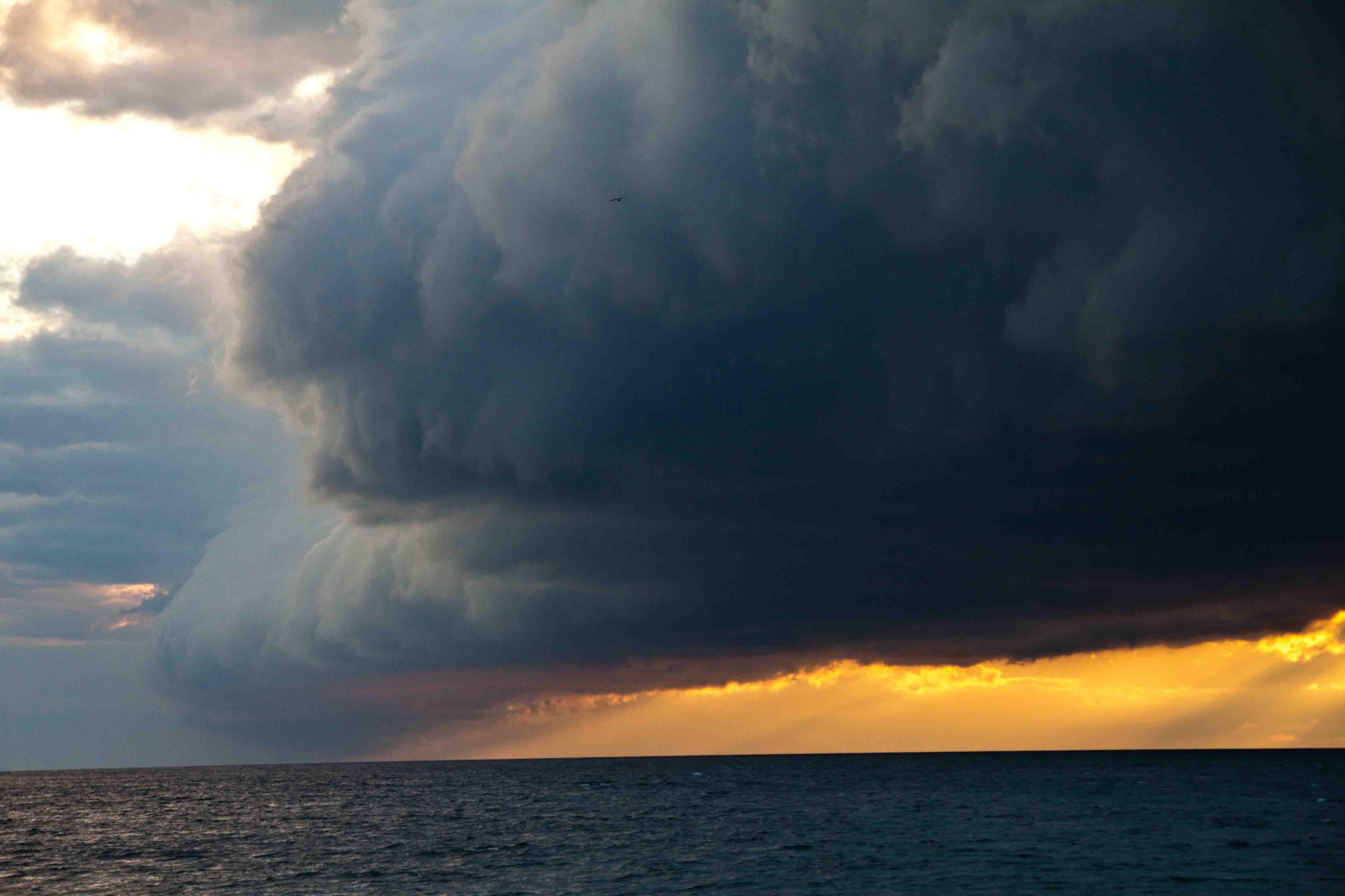
After dinner I stopped at the viewing area on the north side of Mackinaw Bridge just as the sky behind me was filling with dark, storm clouds. Some almost looked like roll clouds. I snapped a handful of photos from the north side of the bridge, paid the $3.50 toll, and raced across the metal grated, middle lane to Mackinaw City in order to capture the bridge with the clouds to its west side.
By the time I parked and walked to Lake Huron’s shore on the east side of the bridge, the clouds had almost reached the shore of Lake Michigan on the west side of the bridge. The storm was coming in fast as the sun set and the waves churned in the two Great Lakes.
While I wondered if I should prepare for a tornado, many pedestrians seemed oblivious to the approaching weather and went about exploring the
lighthouse and Lake Huron’s shores in the city park. Once a few big rain drops landed on target, I hopped in VANilla and headed for the Walmart in Cheboygan for the night. I loved to say that word…Cheboygan. Perhaps I should have stuck around a bit longer…the view from my side-view mirror of the peppermint colored clouds was fantastic! ETB


Other Articles on Michigan You May Like
- Day 219 – Upper Peninsula Drive
- Day 220 – Upper Peninsula Drive – Part 2
- ay 222- The Scenic Sunrise Shore
- Day 223 – The Scenic Sunrise Shore – Part 2
- Day 224 -Lake Michigan Tour
- Day 225 – Lake Michigan Tour – Part 2
- Rambling into Love in Ludington
Shop
Check out the photographic note cards and key chains at my shop. Each card has a travel story associated with it. 20% of proceeds are donated to charity.


