Since we’ve been on the Danube, three days, all of our cruising has taken place at night. Today, however, we enjoyed the river’s beautiful scenery in the Wachau Valley, a UNESCO World Heritage Site.
EXPLORE!
Adventure Travel Photography Blog
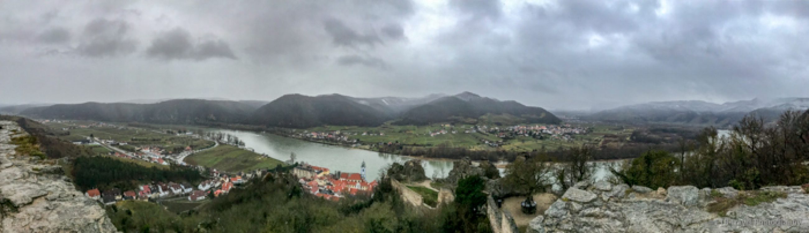
Since we’ve been on the Danube, three days, all of our cruising has taken place at night. Today, however, we enjoyed the river’s beautiful scenery in the Wachau Valley, a UNESCO World Heritage Site.
EXPLORE!
Vienna, originally a Celtic settlement, was subject to attacks and Barbarian invasion that reduced the town to ruins by the early 5th Century. By the 10th century, the German Babenberg Dynasty acquired Vienna and in the 13th century Vienna fell under control of the Habsburg.
Today, Austria’s capital is home to 1.9 million people. Despite Vienna’s large size, its city center, located inside the Ringstrasse, is easily walkable.
LET’s GO
Bratislava, the capital of Slovakia, was founded by the Celts in the 2nd century BC. Being close to the Austria Hungarian border, Bratislava was subject to many power struggles. Bratislava served as capital of Hungary from 1574-1784 during the Ottoman rule before the Austro-Hungary Monarchy reigned.
In the early 1900’s the Czechs and Slovaks declared the creation of Czechoslovakia and Bratislava became a part of this country. After World War II, Czechoslovakia fell under communist rule. The new country Slovakia was created in 1993.
Bratislava, with a population of 450,00, is Slovakia’s largest city. It occupies both banks of the Danube River. The city’s lovely Old Town, that is easily walkable, is on the north side of the river.
EXPLORE!
I am a member of several Colorado “Meetup” hiking groups, and I stumbled across a backpacking trip to Alaska. I have always wanted to visit Alaska in the summertime (been in the winter), so I signed up as soon as I saw the post and there was already a waiting list. Continue reading “Backpacking Resurrection Pass in Chugach National Forest”

Motovun is an Istrian hill town home to just over 500 locals and dramatically located 1,000 feet above vineyards and forest. Parking is located atop the steep, twisty road, though to reach Old Town, visitors must take a steep 10-minute walk uphill. Continue reading “Top Things to Do in Motovun, Croatia”
For most international flights, I choose a major carrier, but for my trip to Colombia, in order to find decent connection times, I opted for Copa Airlines. I have used the airline for intra-South America flights, but it had a been a while, and I wasn’t sure what to expect flying from Denver International Airport.
Copa Airlines began operations in 1947 as a domestic airline in Panama. Over time, it dropped its domestic flights and expanded to international flights in South America. Before Continental merged with United, Continental was a 51% owner of the airline. Copa flies 737s and while it generally focuses on South America, it has expanded into additional North American cities and even to a few European destinations. With only one crash with fatalities, its safety record seems better than many airlines. Continue reading “Why To Fly Copa Airlines”

I enjoyed two days in Durango after finishing the Colorado Trail. Given I had just backpacked 53 miles on the Colorado Trail, I opted for an extremely relaxing day. I stayed at the Best Western Durango Inn & Suites. It is conveniently located at the South end of town within walking distance of Durango’s historic district loaded with shops and restaurants as well as the Durango & Silverton Narrow Gauge Museum and Train Station.
I started the day at Durango Bagel as it is located near the train station and I planned to take the train ride to Silverton. Durango Bagel seemed popular among the local young folks. After grabbing a breakfast sandwich, I wandered over to the train station to find out about my ticket that I ordered online the previous evening.

I recommend getting the ticket sooner than I did (especially in the summer) as many choices were sold out. The weather had been so bad the previous month, however, I wanted to wait as I was interested in one of the open-air cars. After having read many reviews, I wanted to take the train from Durango to Silverton in the morning and to return on the bus in the afternoon for a different view and a shorter ride. This option wasn’t available, so I picked the reverse and hoped for clear skies in the afternoon.
I found the narrated bus ride to be uneventful. I suppose if one hasn’t spent much time in the mountains, the drive would be nice, but frankly, I saw most of these views on foot multiple times over the last month. In addition, the bus driver short changed of us Colorado Trail hikers 10 miles and then said thru-hikers took 2.5 months to hike it rather than 1.5 months at most. Then, after he literally pointed out every gulch and mountain, he drove right by the trail without saying a word! OK, I am being hard on him as he was very knowledgeable. I suppose I was still relishing in my glory of completing it!
Anyway, upon arrival in Silverton, I climbed up to Christ of the Mines Shrine which overlooked the town, stopped for lunch at Thee Pitts Again which was featured on Diners, Drive-Ins, and strolled along the main street as well as through the red-light district one street over. The town is pepper with old buildings including the old jail and a variety of shops, including a nice antique store. It doesn’t take more than a few hours to explore the whole town which is all I had before I boarded the train just as a rain and hail storm hit.


I paid extra for the Knight Sky car which had a glass roof and open-air sides. As we started, I was getting rained on, though I had rain gear. Less prepared passengers were given ponchos, umbrellas and blankets. Fortunately, the storm didn’t last long and by the time the train left the station, the menacing cloud had left. I’m not certain the Knight Sky car is worth the extra money, as I hardly ever sat in the plush seat for the three-hour ride. I mostly stood outside the car on the platform or talked with the leader of a Kiwi group that was driving Mustangs around the Western United States for 33 days! The car wasn’t crowded which was nice. I’m unsure if the other cars were crowded. All cars have windows that open, and it is best to get one toward the end to keep from breathing the ash from the steam engine. Protective eye-wear is a good choice too.


I loved the train ride. Despite having hiked through parts of this area, and even having crossed the tracks on the Colorado Trail and having followed the Animas River, this train ride offered spectacular views of the river, old mines and more. Also, some of Butch Cassidy and the Sundance Kid was filmed on the tracks. I think it would have been a little better to ride the train from Durango to Silverton rather than the way I went. Not for the scenery, but for the stories the train attendants tell. The Kiwi group rode the train both ways, so the attendant, who was great, limited his stories on the return. As far as scenery, the train criss-crosses the river many times, so either side has good seats, but for the high section of the tracks, it is best to be on the left going from Silverton to Durango. I’m really glad I rode the train, and I suspect the bus was a better choice just because the train ride would be long for both directions.
Upon arrival into Durango, I deboarded the train and head to Himalayan Kitchen, a great Nepalese Restaurant. The food was delicious. Still looking to catch up on sleep, I headed back to the hotel early and awoke with renewed energy to explore Durango for another day.

I started out with Durango Diner as I loved dine food. Bacon, eggs, and hashbrowns…who can go wrong with that? Afterwards, I checked out the free museum at the train station. The museum includes far more than just trains..old cars, WWII gear, stuffed bears and more.


Next, I stopped at Bread where I picked up a sandwich to take with me on the trail that follows the Animas River through the town. I walked part of the trail and sat on the riverside as I watched many enjoy water sports like tubing and kayaking.


Happy hour included a beer a Ska Brewing just next to Ken and Sue’s, a fantastic restaurant that I shared a meal with some of my fellow CT hikers. All of our meals were outstanding! It was a great way to end our hiking. ETB


WANT TO TAKE THIS ARTICLE WITH YOU? DOWNLOAD IT HERE WITH THIS GPSMyCity TRAVEL APP LINK:
Surprise Trailhead
Fees: None
Website: http://www.protrails.com/trail/450/summit-county-eagle-county-clear-creek-county-upper-cataract-lake-and-cat-lake
Elevation: 8,605-10,744 feet (below treeline)
Distance: 10.9 miles
Hours: Any…Careful for hunting season
I had such a great weekend! On Saturday, I went up to Schussbaumer, a ski chalet in Breckenridge, for a work party. There was hardly any work to do, so I just got to enjoy a relaxing day in the mountains and got to catch up with my friend Cat. I love that its just a short roadtrip for me to enjoy the Rocky Mountains…no flying across the USA.
I stayed the night at the chalet, and met up with Cat the next morning. We started out with a great breakfast at Clint’s. We were good and got eggs, but the muffins and cinnamon rolls sure looked delicious!! It was probably better to load up on protein since we planned on a 10.9 mile hike to Upper Cataract Lake.
Uniquely, just a month ago, a few of my fellow hikers and I aimed to hike Lower Cataract Lake, but accidentally ended up on the Upper Cataract trail (Surprise Trailhead), but we were limited on time and weren’t able to get to any of the lakes on the route. The last time I hiked the trail, we stopped at the trail intersection at mile 2.7 for a 5.4 mile jaunt as we admired the colorful aspens. This time, we climbed up the steep trail peppered with aspen leaves as they had already fallen. Then we entered the conifer forest laden with fallen trees.


The sun was out and the sky was clear on this 65 degree day. We worked up a sweat as we tackled the sharp grade. At the trail intersection, we turned right and continued climbing, though the terrain began to level out. As we were walking along, it was about time for a bathroom break. We scanned to our left and were surprised to see a lake concealed by thick timber! The name of the lake was appropriate…Surprise Lake.


We didn’t expect to reach it so soon, nor did the landscape seem to suggest we’d stumble across a lake here. Lily covered, it was quite different than the alpine lakes we generally strive to reach. We stopped for a short while, but the sweat on our backs coupled with the cool breeze encouraged us to continue.
It wasn’t long before my stomach started to grumble. Of course, we wanted to reach a lake but we stopped for a snack. We originally thought Surprise Lake was just a random pond, so we thought we would be at another body of water within the hour. Not so. We kept going and going while crossing a few streams. We even descended over the ridge toward a talus field.


On this side of the ridge, the wind was relentless. We gave into the elements and stopped for our hat, gloves, and puffy jacket. We also decided on a snack because we weren’t certain when we’d see the lake. Then Cat pointed to the right as she looked through the trees below and questioned, “Wait, is that a lake?”
Sure enough, it was! We threw our packs on and headed down the trail as we admired Eagles Nest Peak lightly dusted in snow. Soon we turned the corner and enjoyed a remarkable view of Cat Lake. At the time, we thought this was Upper Cataract Lake, but when we reached another trail junction, the sign suggested otherwise.


We were pretty cold at this time and weren’t willing to hike much farther, so we figured we’d actually read the description of the trail that we had on our phones! We warmed up a bit at the trail junction as we stood in the sun with some protection from the wind. This new warmth coupled with the good news that Upper Cataract Lake was only a tenth of a mile up the trail rejuvenated our spirits.


First we found a small pond and then a large lake tucked beneath the towering mountains. As much as we would have liked to sit by the lake for lunch, the wind was brutal! We climbed over a small, rocky ridge to find shelter and enjoyed a lovely view while we soaked in the sun. It’s amazing how cold 65 can feel with 40 mile per hour winds!
On our way back, we opted not to explore Cat Lake though the shore sure looked beautiful. We climbed back up the trail past the talus field and soon descended to the other side where we began shedding layers and enjoyed a pleasant walk back to the parking lot. It was a great day and gorgeous hike. We were pleasantly surprised by all the lakes! I’d highly recommend this trail especially during the fall color change. ETB
Check out the photographic note cards and key chains at my shop. Each card has a travel story associated with it. 20% of proceeds are donated to charity.


For David’s birthday weekend, we visited Aspen and backpacked to Conundrum Hot Springs. I left earlier than he did so I could wander the streets of the quaint mountain town. I took the longer scenic drive from Denver which took me over Independence Pass. I made my first stop here. I parked the car in the lot at the pass and followed a trail to the edge to view the lovely surrounding mountains. The cool breeze sent me back to the car relatively quickly where I continued on to Aspen.


I stopped at a sandwich shop, Grateful Deli, for lunch. I thought I might be able to find something for a reasonable price. The meal deal which included a turkey sandwich, chips and a drink was $13…Ha! That sounds about right for Aspen. The shops were nice as well, Van Cleef and Arpel, Ralph Lauren, Rag and Bone among other fancy retailers.
David and I got a great hotel for the night. Hotel Durant was a few blocks from downtown and the ski mountain…easy walking distance to both. The room was spacious with a nice view. We were able to squeeze into the bar after a short wait for a nice dinner at Wild Fig. From there we tried out the brewery before turning in for the evening.


Conundrum Hot Springs is a popular destination. The hike in from the parking lot is about 8.5 miles. We slept in until 7:30 and grabbed a quick free breakfast at the hotel before we made our way toward the trailhead. We knew with our late start, the parking would likely be a challenge. Of course the small lot was full, so we dumped our packs by the start and then drove a mile back to the main road where we parked on the shoulder.
So our day started by adding a mile to our hike. At least it was without a backpack. The next 8.5 miles led us mostly uphill over a rocky path. We passed through beautiful aspen groves, intermittent forests, and fields of wildflowers beneath a sunny sky. Fortunately, there was a light breeze that kept us cool in the unseasonably warm weather.


The wildflowers were nice though the dry, warm weather seemed to take a toll on them just as the biting flies took a toll on us. I’m not sure why I felt like this hike was so hard. It was my first time to carry a full backpack for the season, and it was steep in places, but it didn’t seem like I should have been struggling so much.


I will say I didn’t find walking across a boulder field or balancing on a log in the beaver pond to be too exciting. The variety on the trail, however, did provide nice changes of scenery which was quite enjoyable. About half a mile from the hot springs, we set up camp around several others. This area is so popular privacy is tough to come by and campfires aren’t allowed.


We hiked the rest of the way carrying a small day pack which included our swim suits, towel, sunscreen, off and the like. There were two hot springs, one larger than the other. Ten or so people sat in one that was a touch warmer than the smaller one which fit 4-6 people comfortably. Both springs were very muddy.

David could have sat there all day. I, on the other hand, tried to sit there for a whole hour. Once I had shriveled up, I was ready to go. Actually, probably before that, but it was his birthday! We hiked back down to camp to cook dinner and have a nap. He mentioned he might head back up there in the morning. The morning came around 2am for him. He hiked up in the dark and sat in the pool with a few others who didn’t bring a tent so they just slept in the springs! He stayed until the sun came up and then some!
Once 7am rolled around, I figured I should check to see if he was alive. I hiked up to the springs and probably ruined his fun when I reminded him we had to cook breakfast, pack up, hike down, and drive four hours home. Though I think he enjoyed a night under the stars.
The hike down wasn’t too bad though with all our ailments between the two of us, we realized our backpacking days might be replaced with easier activities in the next five years. Upon reaching the parking lot, we wished we didn’t have to walk the extra mile to our car. Fortunately, a couple of guys picked us up.


After treating ourselves to a deserving lunch at the White House Tavern, we took a slight detour to Glenwood Springs before heading back to Denver. I wanted to see the historic Colorado Hotel where my mom used to stay as a kid. It is neat. I will have to stay there one day. Of course, the metering at the Eisenhower tunnel was in force, so the drive home took a while, but it was a nice getaway to the mountains. Aspen is a beautiful place! ETB
For notecards and key chains, visit My Shop on this website.

Pawnee Buttes Trail
Location: Pawnee National Grasslands
Fees: None
Website: Pawnee National Grasslands
Elevation: 5,230 feet
Distance: 4-5 miles roundtrip
Hours: Always open
For Easter, we had a three day weekend and lots of snow in the mountains…up to four feet in four days. This snowy event was very exciting to skiers and snowboarders who have suffered through a rather warm March (which I loved). So, for two of three days, David took advantage of the fresh powder, while I locked myself in the house and waited for sun.
Staying home on a three day weekend is almost unheard of in this family, so on Easter with a sunny day on hand, we opted for a short road trip. Tired of the snow, I picked Pawnee National Grassland in Northeast, Colorado. It is about a 2 hour drive from Denver. Within about one hour, we were out of civilization. The Google Maps route took by ranches, dairy farms, and several oil and gas wells. We passed one small town, Briggsdale with a post office and gas station (the only one to be found in the next 60 miles), but otherwise we were surrounded by fields. The last 30 minutes of our drive were on dirt roads which we shared with several speeding gas tankers.
Given the flatlands, we thought we would have seen the two buttes that rise 300 feet above the ground, but they didn’t come into view until we reached the parking lot. We were the only car in the lot with the nice covered picnic tables and bathroom facilities nearby, when within minutes two other cars arrived. Given how far we drove, we found it funny that the only other people at the Pawnee Buttes Trail the entire time we were there arrived at the same time we did!


We actually drove for longer than we hiked, so I can’t say this hike would be for everyone, but it was a bit unique and rather peaceful. From the trailhead, the buttes don’t look that far away and they looked relatively close together. The hike, however, was two miles to the westerly butte and another half mile to the butte to the east.
We followed the trail along the highlands and then down into some badlands around Lips Bluff where raptors nest. From March-June visitors are not allowed to hike into this bluff as to protect the birds. I had hope to see some of the hawks, eagles and falcons for which the grasslands are known, but I suppose they were all protecting their young. We did spot one pronghorn and a few prairie dogs along our drive. It’s always a treat to see wildlife. The grasslands are also known for its fossils, but we didn’t find any (not that we were looking too hard). We were more entertained by Molli who is a very well-minded dog we have been caring for over Spring Break.


After two miles, we reached the first butte. Its base of crumbling sandstone is capped with limestone. It is what is left of the eroded, windswept plains. We followed the footpath another half mile to the second butte. This path had a little snow remaining from our big storm a few days and Molli loved it. She ran back and forth on the snow while trying to eat it at the same time!


Somewhat high on the second butte, is a small narrow path which circles it. We climbed up and enjoyed a lovely view as we strolled around the butte before heading back to the car. It was a nice leisurely day beneath sunny skies with a cool breeze. I don’t think we hiked enough to keep the pounds off from our Easter dinner feast at Linger with some friends that came in town from Canada, but we loved it. It was a perfect way to cap off the evening. ETB


Check out the photographic note cards and key chains at my shop. Each card has a travel story associated with it. 20% of proceeds are donated to charity.
