Day 279 – Columbia River Road (Part 2) and Mount Hood – Columbia River Gorge Loop

Another wonderful day in the Pacific Northwest!  After a quick snapshot of Mount Adams, I took
a short jaunt west from Trout Lake to explore an ice cave.  I expected to be taken on a guided tour, but
instead found myself alone in the Gifford Pinchot National Forest.  Beneath the evergreens by a picnic area is
the entrance to a lava tube.  The cold air
from the winter is trapped inside the cave forming an ice pool with stalagmite
ice crystals poking upward from the floor.
Based on the information board map drawing there are two ice
pools, a natural bridge, a crystal grotto, a crack room, and a few pits.   I only
explored the first ten feet of the 400 foot cave as I was alone and had no
intention of falling on ice and sharp lava in the dark!  I also followed a path above ground which led
to the crack room and the pits.  Had I
had the proper equipment and a partner, I would have liked to see the crystal
grotto.  I bet it would be fantastic
especially closer to winter time.  The
weak beam on my flashlight just barely illuminated the area from a distance,
but neither my eyes nor my camera were successful in focusing on much!

From the ice caves, we continued slightly further west into
the forest where we found a natural bridge which looked like it was formed when
a lava tube collapsed.  Bushes whose
leaves were beginning to turn red with the fall weather blanketed the ravine as
Douglas firs, red alders, and hemlocks reached to the sky in the surrounding
forest.

Late morning, Petey and I finally left the forest and headed
back toward the river’s edge.  As we
followed along Highway 14, the moist forest climate turned arid upon reaching barren,
golden hills.  Amid these hills, is a
French-style chateau which houses the Maryhill Museum of Art.  The chateau, constructed of concrete, was the
inspiration of turn-of-the-century capitalist Sam Hill.  Paintings by Rodin and other European masters
can be found inside while a variety of sculptures can be found on the shaded,
manicured grounds where peacocks strut.

In addition we stopped at a few roadside viewpoints
including one near Celilo Falls, a sacred Indian fishing area, which now lies
beneath the dammed river.  Indians
accepted $26 million in 1957 in exchange for allowing the Dalles Dam to flood
and silence the falls.

Just a few miles east of the museum, we visited Stonehenge,
a concrete replica of the original, which Hill built as a memorial to
Washingtonians who fought in World War I.
Hill’s Stonehenge was the first monument in our nation to honor military
personnel.  It is said that the Quaker
pacifist began constructing the monument which was completed in 1929 after
visiting England during the 1914-18 conflict and was told it had been used for
human sacrifices to pagan gods.  Today,
the sacrifice legend is generally discredited, and it is believed Stonehenge was
a device used by stone-age astronomers to measure time and mark seasons.

After visiting the monument, we crossed the Columbia River
to follow its southern banks back toward the west in northern Oregon.    After
passing through The Dalles, I maneuvered VANilla along the historic Columbia
River Highway which switched back and forth up Oregon’s hills.  Ornate guard rails lined the winding
road:  some of painted white wood and
some of chiseled stone decorated with arches.
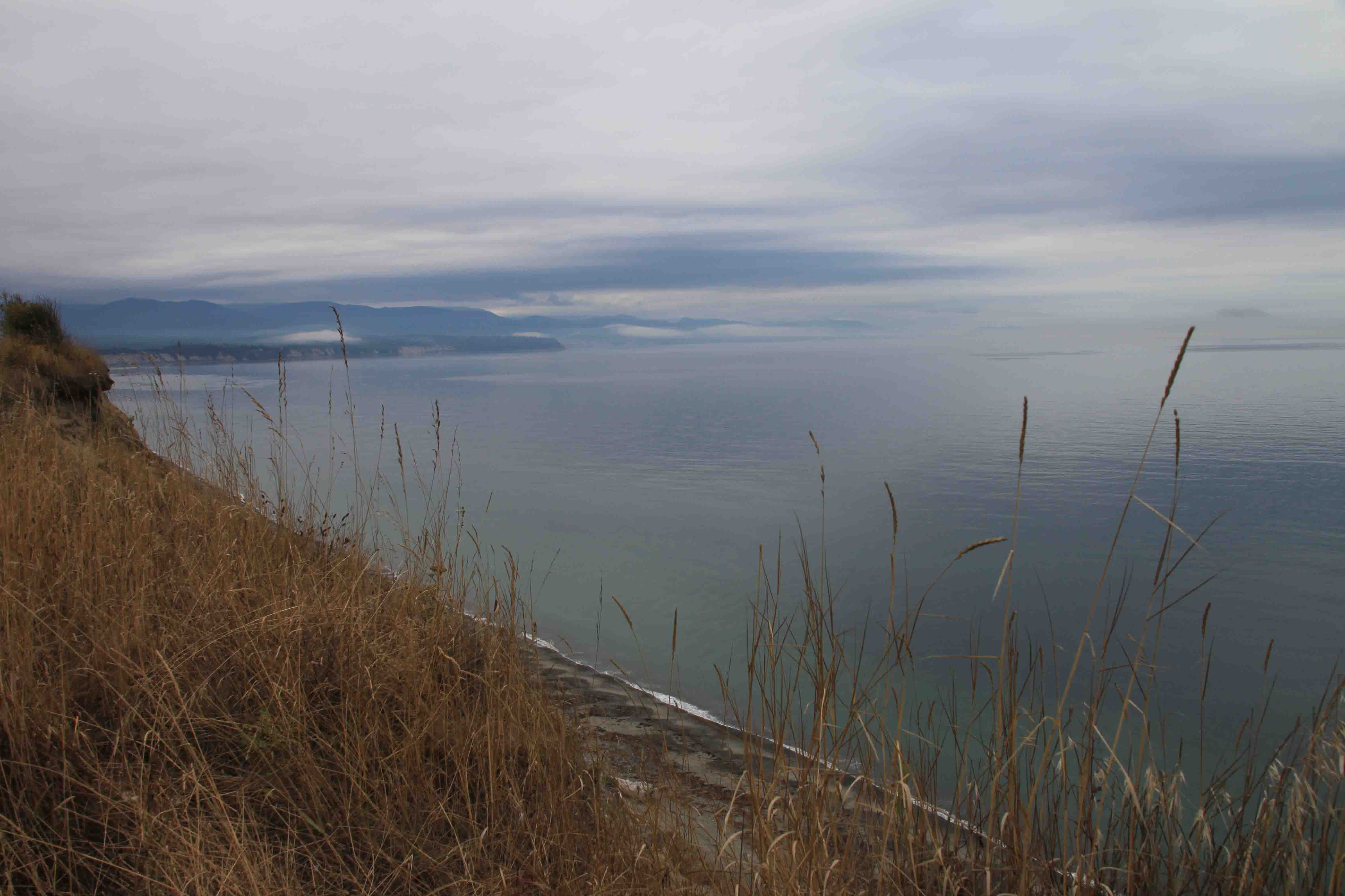
We enjoyed a lovely view from the Rowena Overlook on a still, calm
day.  It would have been tough to guess
that the Columbia River Gorge is one of the best windsurfing places in the
nation today.

We finished the day at a town campground along the river in
Cascade Locks.  I was pleased to happen
upon the quaint, sixteen spot area with free showers until I realized it would
be a noisy night.  I was camped about
twenty yards from active train tracks!
Still, it was a nice place to find.
ETB

Day 278 – Columbia River Gorge

Today I headed inland along the Columbia River on the
Washington-Oregon border.  I spent my
time on the Washington State side and stopped to enjoy the panorama of Oregon’s
wooded hills and of the powerful river that lay at the foot vertical cliffs
from Cape Horn Viewpoint.

As I made my way east through this breathtaking area, I
reached Beacon Rock State Park where Petey and I followed a lovely trail
through the lush forest to Hardy Falls, Pool of Winds and Rodney Falls.  As we wandered along the trail, we came
across a bridge that crossed what was almost a dry creek bed.  A thin trickle of water rolled down the steep
hillside.  I thought to myself, if this
is the falls, I’m going to be one disappointed hiker.  Much to my relief, slightly further ahead, I
came across two signs pointing to the attractions.

Hardy Falls was nothing to write home about as the view was
relatively blocked by vegetation, but the Pool of Winds and Rodney Falls was
inspiring.  A path led us past a boulder
and up to a rock outcropping.  The falls,
tucked in the back of a cylinder of rock, cascaded down a mossy log into a pool
of water before it zigzagged down the rocky shelf to the creek.  Spray from the falls assisted by a tunnel of
wind cooled the air and dampened the rocks where we stood.

Upon return from our two mile hike, we stopped to admire Beacon
Rock situated across the road on the bank of the river.  This enormous monolith, almost 850 feet tall
and second only to Gibralter in size, is the core of a vanished volcano.  Lewis and Clark referenced the rock several times
in their recordings of their expedition.

lamprey

From the park, we traveled about five miles or so to the
Bonneville Dam where, along with a cormorant, I got to watch salmon swim up river through the fish
ladders to spawn.  Humans count each type
of fish that passes through the ladders daily and post the counts.  The previous day nearly 19,000 fish passed
through the ladders and year to date over 2 million.  Salmon and Shad make up most of the count,
followed by Steelhead and Lamprey.
Lampreys look like eels that have a sucker mouth which they use to stick
to edges.

After a short time at the fish viewing, we stopped in
Stevenson for a stroll along the waterfront.
The windy day attracted several kiteboarders and windsurfers to the
white capped river.  In addition to the
water enthusiasts, a cruise line that offers an eight day journey on the river
was in port.  When I spotted the paddle wheeler,
I had hoped for a two-hour afternoon jaunt mentioned in my trusty book of
travels.  The operators told me those
types of trips were offered in Cascade Locks on the Oregon side.  I will be there in a few days.

If the drive along the river wasn’t scenic enough, I
followed the Cook-Underwood Road Loop up into the hillside for a spectacular
view of the Hood River Bridge and the majestic Mt. Hood.  Thereafter, I followed Highway 141 north to
Trout Lake where I found a county campground for the night.  ETB

Day 277 – Oregon Coast Highway (Part 3)

I found a campsite last night at Fort Stevens State Park
which didn’t make my scenic drives book.
The campgrounds were enormous:
550 sites.  It was like a small city.  Before I left the park this morning, I
enjoyed some of the sites; the first being the wreck of the Peter Iredale.  There is nothing special about the wreck of
the Peter Iredale.  It was simply a ship
that had sailed 28 days from Mexico that was bound for Portland to pick up some
cargo.  Strong winds and rough seas
forced it onto the shore where a portion of the ship remains today and has
become a popular tourist attraction and hence its fame.

Just inland from the beach is Coffenbury Lake.  The tranquil lake, nestled in the trees, is
stocked with trout and a popular fishing location for campers.  Petey and I took a short walk along its shore
before turning north to Astoria.

Astoria, a bustling seaport, is located where John Jacob
Astor’s fur-trading company established a post that became the first permanent
European settlement in the Pacific Northwest.
At first I was slightly disappointed, but then I drove to the top of
Coxcomb Hill to visit the Astoria Column.
I’m not sure what I expected; but the Column 125 feet high and constructed
of concrete was remarkable.  It is one of
12 historical markers erected in the early 1900s between Minnesota and Oregon.  The markers were a pet projected of Ralph
Budd, president of the Great Northern Railroad.
His goal was to salute explorers and early settlers for their contributions.  John Jacob Astor’s grandson and the railroad
financed the cost of the Column and the thirty acre site.  The city prepared the land and access
road.

The Column was dedicated in 1926 and cost just over $27,000
to construct.  It includes a 164 step
staircase which was replaced in 2008 for $600,000!  A frieze, over 500 feet long, of 22
significant events that occurred in the region wraps around the exterior of the
Column.  The Italian Renaissance art form
used to decorate the Column is called sgraffito which combines paint and
plaster carvings.  Italian immigrant
artist, Attilo Pusterla depicted scenes such as Indians greeting explorers, the
Lewis and Clark expedition reaching the Pacific, and the arrival of the
railroad with over 200 brown figures.

The views from Coxcomb Hill which rises 600 feet above the
Columbia River were breathtaking.  To the
north a barge approached the Astoria Bridge that connects Washington to Oregon
as fog enshrouded the southern coast of Washington.  To the south rivers snaked through the lush
green hillsides while low clouds hung above the evergreens.  I’m certain the views from the top of the
Column, from which visitors may also throw a small wooden glider off the
balcony and see where it lands, would have also been spectacular except that a
cloud blew in and blanketed the area.

Before leaving and turning south toward Fort Clatsop
National Monument, I grabbed a cache hidden to the side of a nearby trail and
also logged the Column as a virtual cache.
I was just pleasantly surprised by the whole experience.  Fort Clatsop National Monument marks the
location where Lewis and Clark with their crew wintered upon reaching the
Pacific Ocean.  I visited the rebuilt
fort and followed a path to Netul Landing where the expedition came ashore
after its journey along the Columbia River.
Along the way I stepped over a slug and spotted a bald eagle!

In addition, the path led me past remnants of the logging
industry.  Poles or pilings, logs from 80
year old Douglas fir trees, are 60 feet in length and are embedded 20 feet into
the river bottom.  The rows of piling
were used during log sorting and raft making processes.

From Fort Clatsop National Memorial, we continued south
along the coast to Cannon Beach where a 235 foot tall Haystack Rock towers
above.   The bullet shaped monolith is
one of the most photographed sights on the coast…naturally I snapped a few
photos myself.

After a morning outside on a windy, yet glorious day, I
reached Tillamook and took a self-guided tour of the cheese factory.  Forty pound cheese blocks ride conveyor belts
to cutters where the cheese is sliced into two pound loaves.  Workers peel a thin layer of cheese off the
top and sides of the block which gets dumped into a container for
shredding.  Thereafter, the two pound
loaves are sorted.  If the cheese loaf is
over two pounds it is shaved.  If it
weighs less than two pounds a thin layer of cheese is added.  The loaves are then packed and sent to the
warehouse to age.

The factory includes eight vats of milk.  Each vat holds 53,000 pounds of milk.  It takes ten pounds of milk to make one pound
of cheese.  On average, each vat makes
three batches of cheese per day.  Over
1.7 million pounds of milk arrive at the plant every day and approximately 167,000
pounds of cheese are processed daily.

There are 120 dairy farms in Tillamook County with around
28,000 cows.  The average herd size is
150-200 cows.  For every milking cow, the
farm generally has a young cow as well.
It costs $1,500 to $2,000 each year to feed a milking cow and half that
for a non-producer.  The average yearly gross
income per cow is $3,500.  A cow can
drink a bathtub full of water per day.
It takes two gallons of water to produce one gallon of milk, and a cow
can produce six to eight gallons of milk a day (100 glasses).  There are approximately 350 squirts of milk
in a gallon!

After the self-guided tour I sampled a variety of the cheeses.  Tillamook is best known for its medium cheddar, though the line at the ice cream counter made it seem like ice cream was their specialty.

Back on the coast, I stopped at Cape Meares State Park
located at the northern part of Three Capes Scenic Loop.  Cape Meares is home to a hundred year old
light-house which offers magnificent views of the rock coast and the Octopus
Tree.  The Sitka spruce, which can be
reached by taking a short trail through the forest, has no central trunk, but instead
six limbs which extend horizontally from the base as much as 16 feet before
turning upward.  It is 105 feet tall and
between 250-300 years old.  It is unknown
whether forces of nature shaped the tree or if Native Americans played a part
in its formation.

I tried visiting the second cape along the loop road, Cape
Lookout, but after a handful of detours, I threw in the towel and moved onto
Cape Kiwanda State Park.  The park is
known for its red and yellow sandstone cliffs.
Photographers enjoy capturing the colors on SD cards while hang-gliding
enthusiasts enjoy launching off its dunes.
I have to admit I was disappointed in the cliffs.  I must have arrived too late in the day, as
it was a bit shadowy, but the crashing waves were a joy for the countless
surfers.  The enormous rock guarding the
harbor with the sun shining through a small opening was somewhat cool, however.

Continuing south on Highway 101, I reached Lincoln City,
home to the shortest river in the world.
D River flows 120 feet from Devils Lake into the Pacific Ocean.  After a quick visit, we moved on to Depoe
Bay, the world’s smallest navigable harbor, only six acres.

We followed the coast all the way to Newport before turning
inland and traveling through the wine country on our way back to Portland.  It was a long, yet wonderful day!  ETB

Day 276 – A Day in Portland

So I spent Saturday evening and the majority of Sunday with
Casey, Ross, and their two wonderful children, Griffin and Claudia.  The connection, as usual, is from the horse
show days.  Casey competed in jumpers
while I rode hunters.  Casey’s husband
Ross owns his own software development company with another partner and enjoys
cooking (more about dinner in a minute).
Griffin is a SMART fifth grader who likes Lego Robots and recently
required an emergency room visit for stitches after a bicycle accident.  Claudia, a bundle of energy, is a first
grader who plays tennis and enjoys showing off the latest fashion.  Three non-matching, colorful socks, one tied
around the knee, was my personal favorite.

For dinner Ross prepared a mouth watering meal;  flavorful steak on the grill, a medley of
vegetables from their garden, a tomato and mozzarella salad, potatoes, and
stuffed mushrooms.  Needless to say, I was
in heaven!

This morning we went to a trendy breakfast restaurant.  The restaurant opened at 9 a.m. and a line of
folks wrapped around the corner waiting to be seated.  Arriving around 8:40, we met Sean and his
boys TJ and Jared, and the eight of us managed to be included in the first
seating, though outside on the patio which fortunately had a roof which covered
us from the stop and start drizzle.  The
brunch menu was full of delights.  Each
time the server carried plates to other tables we all turned our heads and
stared the food down.  The fried chicken
waffle seemed to be a popular choice.
Three fried chicken breasts stabbed with a knife topped a large, puffy
waffle.  I think it could have fed three.

Our table ended up with a few orders of praline bacon, sweet
potato fritters with powdered sugar and cinnamon, waffles, French toast, eggs Benedict,
a three mushroom scramble, and eggs and brisket hash.  The portions were enormous.  I gorged myself and could only finish half my
plate!

After breakfast we were going to wander around the
waterfront, but between the Race for the Cure 5K event and the dreary weather,
we opted for a walk around the neighborhood park with the dogs; Petey, Henry
and Bella.  While the dogs took a nap, we
broke out Settlers of Catan (awesome game) and tried watching the Cowboy
game.  Interestingly, the Fox station in
Oregon played an English Premier League Futbol match between Chelsea and
Manchester United!?!  It was fine with me
because I like soccer too, but really???
I was surprised to see soccer took place of the afternoon NFC game.  Lucky for me, I had a friend who updated me
on the football score…sounded like a nailbiter!

In the late afternoon, Griffin’s Lego Robot Team came over to
work out the programming for their robots based on fourteen tasks their robots
will have to complete in competition.  I
checked out the board and then headed for the coast in a fog and drizzle.  The weather is supposed to clear up tomorrow
just in time for me to enjoy a day on the northwest coast of Oregon before
returning to Portland for another awesome shower and a bed on my way to visit
the Columbia River Gorge.  It sure is
tough to leave civilization and good company these days…looking forward to
returning to Portland tomorrow night!  Upon looking for a campground for the evening, I did finally see some Roosevelt Elk.  I had to take the picture through the windshield.
ETB

Day 275 – Travel Day

I had planned the morning to visit Hoquiam’s Castle and Grays Harbor National Wildlife Refuge before heading to Portland to visit some friends from my horseback riding days.  Both attempts turned out to be a bust.  Hoquiam’s Castle was built in 1897 by a timber tycoon named Robert Lytle.  It is a twenty room mansion, turned Bed & Breakfast.  I suppose I could have wandered into the lobby and looked around, but oddly I felt like taking a full-blown house tour to change things up on this dreary day.

Oh well, I snapped a photo from the outside and then headed toward the refuge which is known for its shore birds.  Sometimes 300,000 birds land here at one time and come from as far away as Argentina to feed on the shrimplike critters in the mudflats.  The gate was closed to the area and an airport was adjacent to the refuge.  It didn’t seem like an ideal place to spot birds unless I was looking for the manmade, metal type.

With that I turned south toward Portland and am currently taking advantage of a very nice highway rest area to blog before I meet my friends.  Rest Areas are interesting places.  I could probably write an entire page on people who stop at rest areas:  truckers, dog walkers, weary travelers, and those that simply HAVE to go to the bathroom…ETB

SHOP

For notecards and key chains, visit My Shop on this website.

Day 274 – Olympic Loop (Part 4)

Day 274 of a Year Long Road Trip Along America’s Scenic Byways

I left the mountains and headed for the coast this morning.  We took a brief drive through La Push, Washington for a view of the harbor before returning to Second Beach, one of many beaches in the Olympic National Park which seemed to encompass the entire western peninsula of Washington.  I really can’t imagine basking in the sun on Second Beach.

ON THE ROAD AGAIN!
wildflowers on hurricane ridge

Day 272 – Olympic Loop (Part 3)

Day 272 of a Year Long Road Trip Along America’s Scenic Byways

We spent the year anniversary of my journey in Olympic National Park.  After a year, I’ve obviously learned quite a bit about nature, geology, history, and geography; but I’ve also learned a few things about myself, Petey, and Scout (when she was with us) that I didn’t know.  I’ve met a variety of kind individuals and feel very rewarded for them to have shared part of their life with me.  My journey has been interesting, fun, and at times both lonely and challenging. 

Amazingly, after a year of traveling to the lower forty-eight states, I still feel like there is so much more to see in this nation and that I will need to revisit many places at more length. Olympic National Park is a good example. I simply sampled a few short trails in different areas of the park.

ON THE ROAD AGAIN!
dungeness wildlife refuge

Day 271 – Olympic Loop (Part 2)

Day 271 of a Year Long Road Trip Along America’s Scenic Byways

Mount Walker

We started out the day taking a four mile dirt road up to the Mount Walker Viewpoint.  There is both a north and south viewpoint.  On a clear day, the Seattle area, Mount Rainier (the highest peak in Washington), Hood Canal with one of the longest floating bridges in the world over tidal waters,
Mount Baker, and several other peaks in the Olympic Mountains are part of the scenic panorama.  Today, however, fog was the only view.  Mount Walker is home to a handful of caches, though, so we picked up a few before bouncing back down to Highway 101.

ON THE ROAD AGAIN!

Day 270 – A Rest Day

I spent the day resting at Dosewallips State Park.  VANilla got a good internal clean, and I stayed near a shower in order to clean my wound.  I did meet a few interesting folks in the town bar where I grabbed dinner and watched part of the football game.  It would be the Patriots…UGH!  Anyway, most of the locals looked like the guy who sat across from me…though I didn’t meet him.

Map of My Road Trip Across the USA

For a summary about my road trip across the USA, click HERE. For the interactive map, see the below link.

Shop

Check out the photographic note cards and key chains at my shop.  Each card has a travel story associated with it.  20% of proceeds are donated to charity.

photographic note card, sandy beach dunes
SANDY DUNES

Day 269 – Olympic Loop

Well, my first day on the Olympic Loop Tour was a memorable
one, though not in a very good way.
VANilla carted us several miles down a gravel road to the Staircase
Rapids Nature Trail, a four mile path that follows a cascading Skokomish
River.  It turns out, the hike was in the
Olympic National Park, where dogs are not allowed on the trails, and this
morning I really wanted to include him on a walk.  Therefore, we turned around and stopped at
Lake Cushman State Park for a trek to the summit of Mount Rose.

The prettiest part of the hike was the first two minutes,
where a waterfall trickled over rocks and a fallen tree.  I took two pictures and realized my SD card
was full, and thus erased the pictures because I thought I had downloaded them
all (to find out later that I didn’t…UGH!!)
The rest of the walk was up a very steep incline which resulted in the
trail being rated as difficult.  We
walked for almost an hour up and didn’t even make it the 1.8 miles to the loop
that circles the top.  Sweaty with flies
buzzing around my head, I opted to turn back, as I wasn’t enthralled with views
of vegetation and trees.  I was hoping to
keep the lovely creek in sight.  In order
to follow the trail downhill without running, I picked up a walking stick to
help slow my momentum.

Just before I reached the bottom, I ditched the stick.  With a can of Off in one hand and Petey’s
leash in the other, I only had to take two more steps before crossing the dirt
road to VANilla when I caught my foot on a log and fell.  The log’s sharp, pointy branches ripped my
shorts, cut my back, and one four inch piece the size of a pinky finger broke
off into my leg!  Being beneath my
shorts, I didn’t realize it at time.  I
just had a severe burning sensation and shredded clothing.  Upon changing my shorts, I noticed the end of
the wood chard poking out of the fat on my leg.
Lucky for me, I store my fat on my thigh!  It kept my attacker from damaging my muscle
or any other vital part of my body.  Of
course, at this point I had a feel-sorry-for-myself, panic session.  Frantic, I asked a guy where the closest
hospital was located.  He said, “Fifteen
miles south to Hoodsport”.  That was a family
practice facility, so I asked a lady in a store and she said, “Twenty miles to
Shelton”.  Naturally, she provided me
directions, but I don’t recall them.  I
just started heading south, trying to ignore the burn and hoping splinters
weren’t breaking off into my leg.

Then it donned on me that my GPS has a hospital icon.  I pushed it and Gina eventually got me
there.  I suppose the beauty of a small
town hospital is that I walked into triage, gave them my ID, and they had me in
an operating room in five minutes or less.  I think the entire procedure of shooting Novocane
into my wound, slicing my leg six inches, removing the branch particle,
flushing it, and stitching with twenty stitches (both internal and external),
and checking out took less time than driving there.  Or at least it would have if they could have
found all of the parts to the water gun that they had to assemble to flush the
wound.

My nurse, Jake, who is in the Navy and has been deployed as
a medic to Afghanistan and Iraq twice each, was super cute!  I kind of wish I didn’t stink so bad I could
smell myself.  No, he was married with
five kids and liked football, so at least I got to watch pieces of a few
football games while Dr. Hautala stitched me up.  Anyway, Jake graciously took photos of my
injury, and I thanked him for his service to our Nation which seemed
particularly fitting given it was September 11th.

Today also marks the six month anniversary of my dad’s
death.  I think the date of this injury
might be unforgettable.  If the doctor
could have only removed some of the fat with my enormous splinter!  Sadly, I’m more upset over deleting my
pictures than the beautiful scar that is going to grace the top side of my
right thigh!

Petey behaved relatively well while being left in VANilla
during my emergency room visit.  We stopped
at the Wal-Mart in town for an antibiotic and painkiller before calling it a
day at Dosewallips State Park.  I’m
currently waiting for my Vicodin to kick in.
We’ll see what tomorrow has in store for me.  I might take a few days of rest…ETB!