
Day 231 of Year Long Road Trip Along America’s Scenic Byways
Mall of the America’s
Since Hastings was only about twenty miles from Minneapolis/St. Paul, I took a detour for a simple drive by as I had never been there. I had Gina, my GPS, take me to the city hall of each town, that way I would at least get a glimpse of downtown. I crossed over a few bridges, passed by several office buildings connected by skywalks, and even spotted a few historic churches in the mix before I ended at Mall of the America’s. While I can’t think of anything I like about shopping, I figured I had to at least see the largest mall in America.

Memorial Park
After our detour, we returned south and made a handful of stops in Red Wing, our first at Memorial Park which provides a superb view of the Mississippi and the city below. During the ice ages, with four major cycles of glaciers melting, floods of meltwater eroded the Mississippi 200 feet deeper than the present channel. Because the tributary streams carried less water than the main river, they were unable to cut down the terrain as rapidly, resulting in steeper slopes.
As the meltwater diminished, the velocity of the main river was reduced and it was no longer able to remove the sediment deposited from the tributaries. Thus, the valley today was filled to its present level and exhibits a series of meanders, oxbow lakes, side channels, sloughs, swamps, and tillable land.

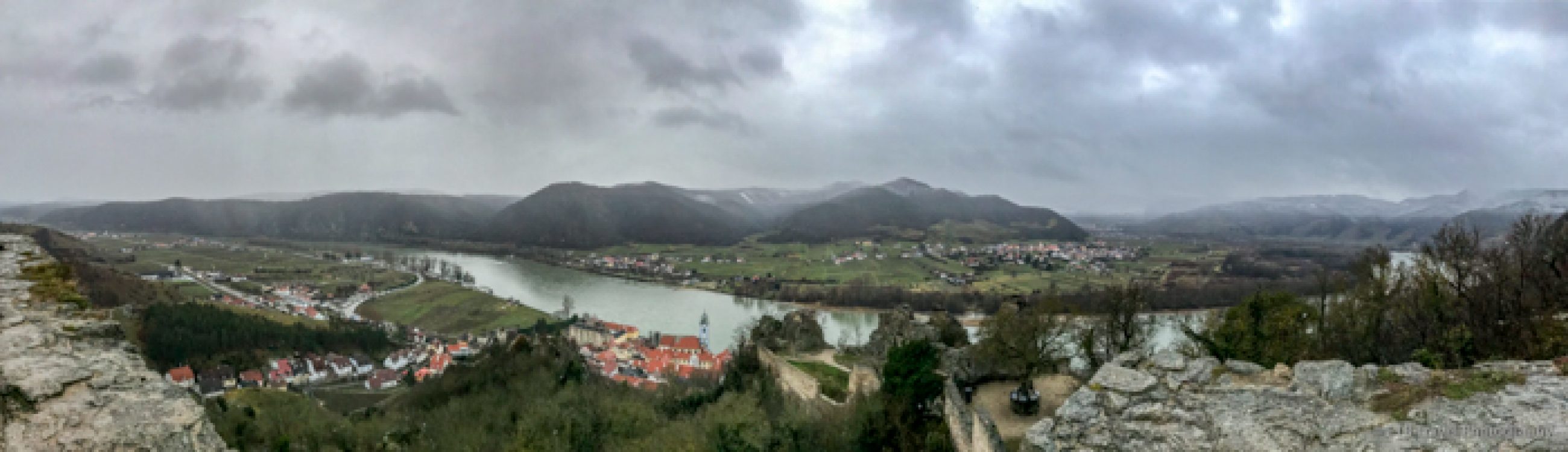
Barn Bluff
From the park, we curved back down the steep, winding road to visit Barn Bluff. This was a really neat place. I felt like I was in Missouri again, walking beneath a canopy of trees and past walls of rock and quarries to catch a few peaks of the Mississippi in the rare open spaces. Before even climbing the stairs, each inscribed with a benefactor’s name in block letters, to reach the path that ascends atop the bluff, we took a short walk to an old kiln.


The G.A. Carlson Lime Kiln, built in 1882, was once one of thirty such kilns operated between 1870 and 1908 in the Red Wing area. The kiln was used for the transformation of Barn Bluff’s raw material into commercial lime, quick lime, or unslaked lime for the use in mortar and plaster. The wood fired kiln was heated to temperatures of 2,000 degrees to burn the limestone. One ton of limestone produced 1,000 pounds of quick lime. The kiln ceased operation after forty years of quarrying when the limestone industry began weakening.


After visiting the kiln, which was also an earth cache, we meandered along the bluff, also an earth cache. The bluff towers 343 feet above the City of Red Wing and is one of the best known natural features along the Mississippi. It was climbed by many of Minnesota’s early tourists including Henry David Thoreau.

We continued south on the Great River Road, paralleling the Mississippi River and passing through the Upper Mississippi National Wildlife and Fish Refuge, a network of wetlands, islands, forest and prairie that extends 260 miles through four states. We stopped at a roadside rest area for a tranquil view of clouds reflecting in the glassy Mississippi waters.

Iowa Border
The Great River Road took us past towns such as Winona and La Crescent before we crossed into Iowa where we attempted to visit Effigy Mounds National Monument. The park is home to over 200 Indian burial pits topped with low, rounded earthen mounds. We got there at 6:15, fifteen minutes too late!

Pikes Peak State Park
Given the time, we carried on through a few more towns where houses on stilts lined the edge of the river and claimed a campsite at Pikes Peak State Park. Yes, the park is named for General Zebulon Pike, the explorer who sited a bluff in Iowa a year before reaching the more famous Pike’s Peak in Colorado.
McGregor
After snagging a cheap campsite that came with a free shower, I drove back to McGregor, a quaint old town with a handful of restaurants and B&B’s. I tried going to one bar type place, but as soon as I arrived at the intersection, a train stopped, blocking my way. I almost chose homemade pizza, when I decided it would be nicer if Petey could join me instead of being left in VANilla on this muggy day. So, as a Texan, with much trepidation, I selected a Mexican food restaurant that had a patio.

I ordered safely…a fajita chicken salad. While the chips seemed slightly affected by the humidity, the Latinos Mexican Restaurant carried Dos Equis Amber (my favorite) and served up a tasty salad, though not all toppings listed on the menu were included (a pet peeve of mine). Regardless, I was pleasantly surprised, not only by dinner but by the brilliant sunset! ETB

Map of My Road Trip Across the USA
Learn more about my road trip across the USA, or click the link below for the interactive map.

Other Articles About Iowa You May Like

Pretty sunset!
xo’s M
ditto