
Fort Robinson
Another enjoyable day in Nebraska…though most of the interesting sites I’ve seen have been within 100 miles of each other, and I have driven over 600 miles over a few days to see them!

We started out today at Fort Robinson where I camped last night. The campground is the site of one of the most tragic events at the fort, the Cheyenne Outbreak. Forcibly sent to Indian Territory in Oklahoma, a band of Northern Cheyenne, led by Dull Knife, escaped and fled across the plains of Kansas and Nebraska. The 149 men, women, and children were finally captured by troops from the fort in October 1878. Told they would have to return to the Indian Territory, they tried escaping again on
January 9, 1879, and the men opened fire on the guards with the few guns they had hidden away as the women and children fled toward the White River. Many of the Cheyenne fell in the battle, one of the last of the Indian War.

Permanent buildings at the fort, originally a camp which was established due to Indian unrest in March of 1874, went under construction in June of 1874. Sioux warrior Crazy Horse surrendered 889 members of his tribe at Camp Robinson in May of 1877. He was later killed when he tried to escape in September of the same year. The
buildings included barracks, a barn, officer’s quarters and the like. Many still stand today and line a horse shoe shaped parade ground with a manicured green lawn. Petey and I took a stroll around the fort area before taking a scenic drive in another part of the park to see some bison. We also spotted a few mules.

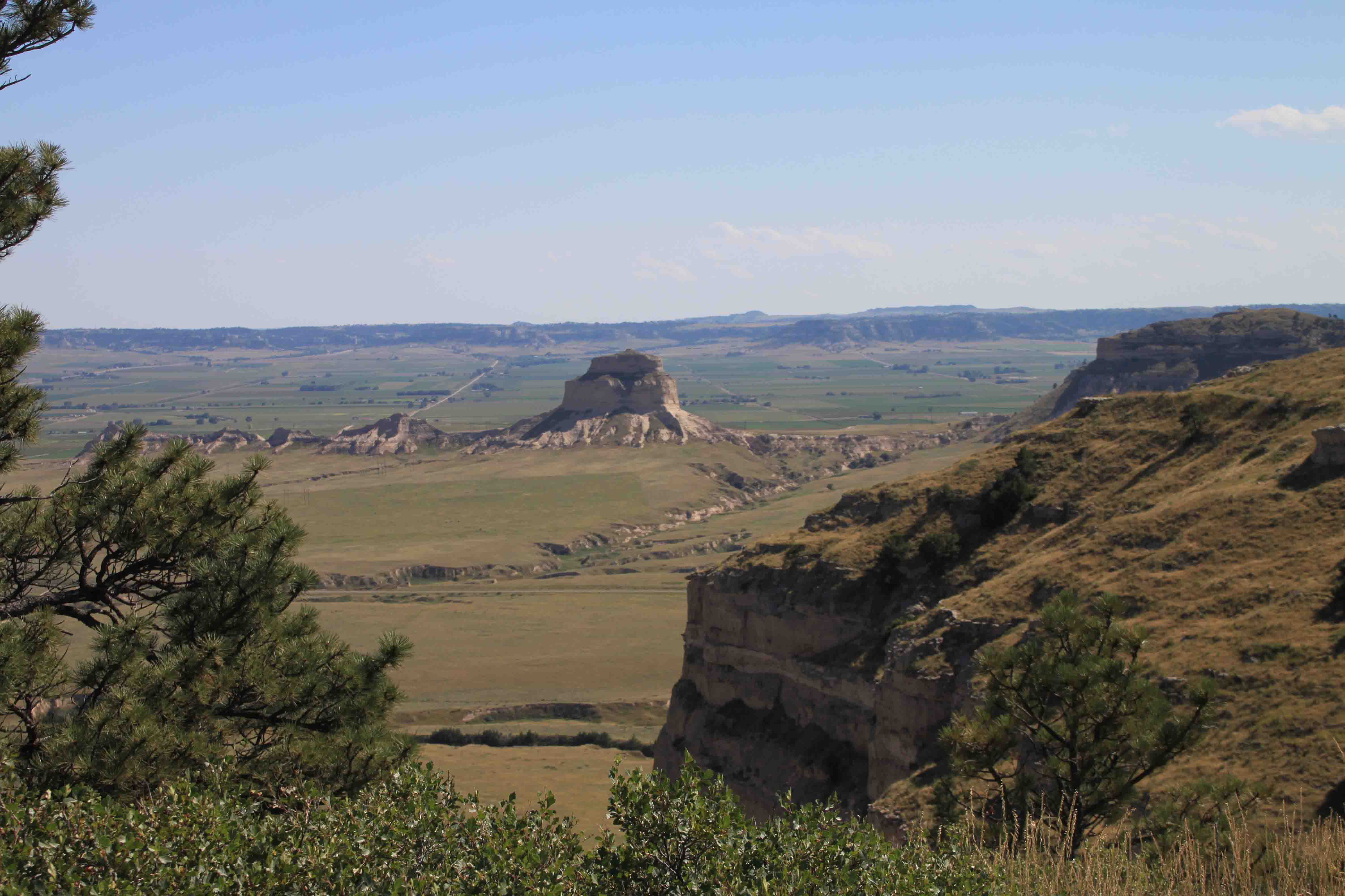
Toadstool Park
After driving 19 miles on a dirt road littered with muddy dips and rock chips and yet may have been the smoothest dirt road I’ve ever been on, VANilla delivered us to Toadstool Park. We visited a 1984 sod house replica of one built in the 1930’s by Kenneth Pelren and Segard Anderson. The early settlers used a plow to break the sod into strips 12 inches wide and 4 inches thick. The strips were cut into three-foot lengths and stacked on each other like bricks to construct the house.


While I found the house interesting, my attraction to the park was its peculiar landscape. Petey and I walked the mile loop through hills of sand and clay devoid of vegetation and severely eroded. Harder rocks perched atop softer material that has eroded to create toadstool formations. These formations were created 34 million years ago when ash from Great Basin volcanoes in Utah and Nevada blanketed the land. An ancient river carved the valley as the landscape changed to semi-arid. The rocks and clays are also home to several fossils that could be seen from the pathway.

Fort Niobrara Wildlife Refuge
From Toadstool Park we headed back to the east past fields of sunflowers and into the Central Time Zone, this time losing an hour, to visit Fort Niobrara Wildlife Refuge. We came to enjoy a lovely waterfall that cascaded over a rock ledge and as an added bonus spotted some more bison and drove through a prairie dog town.


Fort Niobrara Wildlife Refuge was our last stop in Nebraska before crossing the border into South Dakota, a state I have never visited beyond driving through one corner on my way to North Dakota a few weeks ago. We crossed a two lane highway that led us through endless hay fields. Bails of hay dotted the rolling green hills which were occasionally outlined with rock formations popping from the surface until we eventually reentered the Mountain Time Zone and reached Prairie Homestead where a house of sod and log built into an embankment in 1909 still stands. This is a rare exception as most sod houses have washed away.

Badlands National Park
Just next to Prairie Homestead is Badlands National Park, a sea of moonscape. Ridges, spires, and canyons of volcanic ash rich with fossil beds from the Oligocene era dominate the landscape. We found a campsite in the park as the sunset over formations and later enjoyed the full moon. The moon appeared so bright that the stars were imperceptible. ETB